
Canada Gazette, Part I, Volume 150, Number 27: Regulations Amending the Metal Mining Effluent Regulations
July 2, 2016
Statutory authority
Fisheries Act
Sponsoring department
Department of the Environment
REGULATORY IMPACT ANALYSIS STATEMENT
(This statement is not part of the Regulations.)
Executive summary
Issues: Seabridge Gold Inc. (Seabridge) is proposing to construct and operate the Kerr-Sulphurets-Mitchell (KSM) Mine Project, a combined open pit and underground gold, copper, silver and molybdenum mine in northwest British Columbia. This project is expected to affect natural, fish-frequented portions of the upper tributaries of North Treaty Creek and South Teigen Creek due to the disposal of mine tailings. A natural, fish-frequented water body can only be used for the disposal of mine tailings if the Metal Mining Effluent Regulations (MMER), under the Fisheries Act, are amended to add such water bodies to Schedule 2 of the MMER.
Description: The proposed Regulations Amending the Metal Mining Effluent Regulations (the proposed Amendments) would add portions of North Treaty and South Teigen creeks to Schedule 2 of the MMER, allowing the use of those water bodies for the disposal of tailings from the KSM Mine Project. Seabridge would be required to develop and implement a fish habitat compensation plan to offset the resultant loss in fish habitat. Seabridge, and any future owner or operator, is required to submit a letter of credit ensuring funds should the company fail to address all the elements of the fish habitat compensation plan.
Cost-benefit statement: The proposed Amendments would enable the disposal of mine tailings as considered within the federal environmental assessment transitional comprehensive study on the KSM Mine Project, prepared by the Canadian Environmental Assessment Agency (the Agency). The Agency concluded that the KSM Mine Project is not likely to cause significant adverse environmental effects, based on the implementation of the proposed mitigation measures. The KSM Mine Project is expected to bring economic benefits to business as well as local and regional communities.
The proposed Amendments would result in the loss of 10.6 hectares (ha) of fish habitat in the Bell-Irving River watershed, while the development and implementation of the fish habitat compensation plan would create 18.2 ha of new fish habitat within the same watershed, yielding a net benefit of 7.6 ha of fish habitat. The total cost attributable to the development and implementation of the fish habitat compensation plan, incurred by Seabridge, would be $6.9 million. (see footnote 1)
Incremental costs to the Government, associated with the fish habitat compensation plan, would be low.
“One-for-One” Rule and small business lens: The “One-for-One” Rule would not apply to the proposed Amendments as they would not impose new administrative requirements on the regulated community. The proposed Amendments would not trigger the small business lens as the KSM Mine Project, owned and operated by Seabridge, is not considered a small business. (see footnote 2)
Domestic and international coordination and cooperation: Public consultations with local and Aboriginal communities, the U.S. government and the State of Alaska were conducted in cooperation with the Department of Fisheries and Oceans and the Canadian Environmental Assessment Agency.
Background
Metal Mining Effluent Regulations
The Metal Mining Effluent Regulations (MMER) came into force on December 6, 2002, under the Fisheries Act (the Act). The Act prohibits the deposit of deleterious substances in waters frequented by fish. The use of a natural water body frequented by fish for mine tailings disposal can only be authorized through an amendment to the MMER, which adds that water body to Schedule 2 of the Regulations.
Once a natural, fish-frequented water body is added to Schedule 2, section 27.1 of the MMER requires the development and implementation of a fish habitat compensation plan to offset the loss of fish habitat that occurs as a result of the use of natural, fish-frequented water bodies for mine tailings disposal. Mine owners or operators are required to submit a letter of credit ensuring that funds are in place should the owner or operator fail to address all elements of the fish habitat compensation plan.
The MMER also prescribe the maximum authorized limits for deleterious substances in mine effluent, listed in Schedule 4 (e.g. copper, cyanide, and total suspended solids), and require that mine effluent not be acutely lethal to fish. (see footnote 3) Furthermore, the MMER require that mine owners or operators monitor and test effluent to ensure compliance with regulated limits. The Department of the Environment publishes annual performance summaries of metal mines with respect to selected standards prescribed by the MMER.
The Kerr-Sulphurets-Mitchell Mine Project
Seabridge is proposing to construct and operate the Kerr-Sulphurets-Mitchell (KSM) Mine Project, a combined open pit and underground gold, copper, silver, and molybdenum mine in northwest British Columbia. The KSM Mine Project will be located in the coastal mountains of northwestern British Columbia, about 65 km northwest of Stewart and approximately 35 km east of the British Columbia border with Alaska.
The KSM Mine Project is designed to process approximately 130 000 tonnes of ore per day over an anticipated operational life of 52 years. Ore will be mined by a combination of open pit and underground mining methods from four mineral deposits: the Mitchell, Sulphurets, Kerr, and Iron Cap deposits. Crushed ore would be transported via an approximately 23-km tunnel and conveyor to the plant site. The concentrate will then be trucked to port facilities in Stewart for shipping to overseas markets. According to Seabridge, the construction of the mine is expected to begin in 2017.
The KSM Mine Project encompasses two main areas, the mine area and the processing and tailings management area, which are connected by two parallel tunnels (see Figure 1). The mine area includes three separate open-pit mines, two underground block cave mines, rock storage facilities, an ore preparation complex, diversion structures, and water storage and treatment facilities. The processing and tailings management area includes a milling facility and a tailings impoundment area (TIA) into which tailings would be deposited during the operation of the mine.
The KSM Mine Project is expected to produce approximately 9.9 billion pounds of copper, 38.2 million ounces of gold, 191 million ounces of silver, and 213 million pounds of molybdenum. (see footnote 4) A financial analysis, as reported and estimated by Seabridge, forecasted a net present value of $4.5 billion for the KSM Mine Project. (see footnote 5), (see footnote 6)
The mine would benefit the local and regional economy as, according to Seabridge, it is expected to create both direct and indirect jobs amounting to 4 310 and 2 880 jobs respectively during the construction and operation of the mine. (see footnote 7)
Tailings management for the KSM Mine Project
The KSM Mine Project is expected to produce at least 2.3 billion tonnes of tailings over the life of the mine. To manage these mine tailings on a long-term basis, Seabridge plans to construct and operate a TIA located east of, and almost 1 km downslope from, the milling facility.
The TIA would be located within a U-shaped glacial valley containing the natural, fish-frequented upper tributaries of Teigen and Treaty creeks in the Bell-Irving River watershed, which flows into the Nass River and eventually to the Pacific Ocean, southeast of the Canada–United States border.
All water from the mine would be managed within this facility, and most of the water would be recycled for use in the ore milling process. Excess water would be treated as necessary to meet the MMER and provincial permit requirements, and would be released into South Teigen Creek via a spillway.
Figure 1: The KSM Mine Project illustrating the location of the TIA
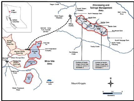
The TIA would be divided into three cells. The north cell of the TIA would be in operation from year 1 to year 25. The south cell of the TIA would be in operation from year 25 until year 52, while the centre cell (CIL) would be in operation throughout years 1 to 52. Tailings from ore processing are expected to contain elevated concentrations of cyanide and dissolved metals, notably copper. In order to mitigate contamination and seepage issues, Seabridge is proposing to separate these high-sulphide tailings into the lined centre cell.
Environmental assessment
The KSM Mine Project was subject to environmental assessments (EA) under both federal and provincial legislation. The Provincial EA considered the full scope of the proposed mine, as proposed by Seabridge, and was completed on July 30, 2014. The Provincial and Federal EAs were coordinated through a single cooperative EA process. A Federal Transitional Comprehensive Study level EA (Federal EA) of the project was undertaken under the former Canadian Environmental Assessment Act (CEAA, 1992) by the Canadian Environmental Assessment Agency (the Agency). The Agency prepared the Comprehensive Study Report in consultation with the Department of Fisheries and Oceans, the Department of Natural Resources, the Department of the Environment, the Department of Transport, the Department of Health, the Department of Indian Affairs and Northern Development, the Department of Canadian Heritage, and Statistics Canada. The Federal EA, completed on December 19, 2014, concluded that “the KSM Project is not likely to cause significant adverse environmental effects taking into account the implementation of the mitigation measures described in this report.”
Seabridge also convened a fully independent, experienced and technically qualified Review Board to ensure that the dams proposed for the KSM Mine Project adhere to design, construction, and operational standards of the Canadian Dam Association. The Review Board is expected to meet at least once per year during the life of the project. The Review Board's findings will be shared with the British Columbia Ministry of Energy and Mines, and with local Aboriginal communities, for information purposes.
Issues
Seabridge proposes to use natural, fish-frequented portions of North Treaty and South Teigen creeks for the disposal of tailings from the KSM Mine Project. However, a natural, fish-frequented water body can only be used for the disposal of mine tailings if the MMER are amended to add those water bodies to Schedule 2 of the Regulations.
Objectives
The objective of the proposed Amendments is to allow Seabridge to utilize portions of North Treaty Creek and South Teigen Creek for disposal of tailings from the KSM Mine Project into the proposed TIA. This would allow the proposed TIA, which was assessed within the Federal EA for the KSM Mine Project, to be constructed and operated as planned.
Description
The proposed Amendments
The proposed Amendments would add portions of North Treaty Creek and South Teigen Creek, in northwest British Columbia, to Schedule 2 of the MMER. Seabridge (and any future owner or operator) would, under section 27.1 of the MMER, be required to develop and implement a fish habitat compensation plan to offset the resultant loss of fish habitat. Seabridge (and any future owner or operator) is required to submit a letter of credit ensuring that funds are in place to cover all costs associated with the implementation of all elements of the fish habitat compensation plan.
Proposed fish habitat compensation plan
Seabridge prepared a fish habitat compensation plan that proposes to create two compensation sites within the Treaty Creek and Bell-Irving River watersheds: the Treaty Creek and the Taft Creek sites. These projects would target both Dolly Varden and Coho Salmon habitats, which represent valuable commercial, recreational, and Aboriginal fisheries.
The Treaty Creek site would be located at the junction of North Treaty Creek and Treaty Creek, approximately 8 km southeast of the TIA and approximately 20 km upstream of the confluence of Treaty Creek and the Bell-Irving River. The site is 2 km long and approximately 500 m wide, and includes a large alluvial fan at the mouth of North Treaty Creek and a flat floodplain of Treaty Creek east of the fan. The existing fish habitat at this site is of poor quality with obstructed fish access and low overall fish productivity.
The proposed Treaty Creek project would provide a large amount of permanent, good quality habitat for rearing, overwintering and spawning. It would also support all life stages of the two target species, Dolly Varden and Coho Salmon. The plan entails the construction of a surface water intake from North Creek to supply reliable flow into a protected side channel and through a series of ponds, the construction of an area of 15 ha of good quality overwintering and rearing habitat in ponds, and the construction of 2 118 m of channels to create an area of 0.4 ha of habitat with complex features. The plan would also enhance functional aspects of wetland ecosystems, provide spawning habitat for Coho Salmon and Dolly Varden and maintain fish access to the site. The fish habitat gains for this compensation site are estimated to be 15.4 ha.
The Taft Creek site would be a large, fourth-order tributary to the Bell-Irving River, comparable in size to Teigen Creek and Treaty Creek, located approximately 25 km southeast of the TIA and 40 km southeast of the community of Bell II, on Highway 37. This site is 1 km long and approximately 300 m wide including low and high bench floodplain terraces on the southeast bank of Taft Creek. At this site, Seabridge proposes to construct 2.6 ha of good quality, off-channel overwintering and rearing habitat in ponds. Seabridge also proposes to construct 968 m of stream channels to create 0.2 ha of rearing habitat with complex habitat features and to maintain fish access. The fish habitat that would be created would include components that enhance habitat value for fish, stabilize slopes and shoreline areas, and create ancillary habitat for wildlife. The fish habitat compensation plan would consist of re-vegetating riparian areas, planting aquatic vegetation, adding large woody debris and other cover features, and adding spawning substrates. It would support the two target species, Dolly Varden and Coho Salmon.
The fish habitat gains for the Taft Creek site are approximately 2.8 ha, resulting in a net gain in area of approximately 18.2 ha for both Taft Creek and Treaty Creek sites. Given that a total area of 10.6 ha of fish habitat would be lost due to the proposed Amendments, the ratio of habitat gained to habitat lost would be approximately 1.7:1 for this fish habitat compensation plan.
Regulatory and non-regulatory options considered
Seabridge prepared an evaluation of alternatives for the disposal of tailings for the KSM Mine Project. (see footnote 8) This evaluation was considered during the Federal EA of the KSM Mine Project to mitigate potential impacts on fish habitat.
Seabridge evaluated 14 regulatory and non-regulatory alternatives for managing tailings, of which four were selected as potentially feasible alternatives to be assessed in detail from environmental, socio-economic, and technical perspectives.
Alternative technologies for tailings management and disposal
In addition to distinct locations for the establishment of a TIA, Seabridge also considered a number of alternative technologies for tailings management and disposal that would not result in a loss of fish habitat, and would therefore not require amendments to the MMER (i.e. non-regulatory options). These include three main alternatives to tailings slurry including thickened tailings, paste tailings and dry stack tailings as well as other tailings disposal technologies, including conventional impoundment, subaqueous or saturated storage, submarine storage, in-pit tailings storage, and co-disposal. Given the large quantity of tailings to be produced, the topography of the KSM Mine Project site, the accessibility associated with the mountainous topography, and the presence of numerous fish-frequented water bodies, Seabridge determined it is unlikely that a feasible and viable TIA could be developed as a non-regulatory option, regardless of the technology used for tailings management and disposal.
Regulatory options for tailings disposal
Regulatory options involve the disposal of tailings in a manner that would result in direct impacts (see footnote 9) on one or more natural, fish-frequented water bodies, and would therefore require that the water bodies be added to Schedule 2 of the MMER for the option to be implemented as proposed.
As stated above, Seabridge identified 14 potential tailings storage sites for a detailed assessment, of which four met the pre-screening criteria. All four alternative sites identified for further consideration are considered regulatory options, given that they would directly impact fish-frequented water bodies. The four regulatory options and their characteristics are listed below, in Table 1. The remainder of the alternatives were not further considered due to limitations such as large dam requirements, poor dam foundations, water management issues, insufficient tailings capacity, and distance from the mine site.
The preferred single-site alternative (Option 1) would be located in a U-shaped valley between North Treaty Creek and South Teigen Creek, approximately 24 km east of the mine site. The elevation of the valley base ranges from 840 m to 900 m, and valley slopes rise up to a maximum of 1 900 m. The site configuration is favorable for tailings storage due to gentle slopes and greater tailings storage capacity. The preferred TIA would require the construction of four containment dams: a north dam, a southeast dam, a saddle dam, and a splitter dam. The north, saddle, and splitter dams would allow staging the TIA into the north and centre cells in the first 25 years of the project. The south cell would be in operation from year 25 to year 52. The total dam volume of 190 million cubic meters would allow storage of 2.67 billion tonnes of tailings, which would provide 100% of the required tailings storage for the life of the KSM Mine Project. Two seepage collection dams would be constructed downstream of the TIA.
Option 1 has been identified as the preferred option as it would provide more than sufficient storage capacity at one site, favorable conditions for dam construction, optimal water management and good natural groundwater containment from ridges on each side of the TIA. This option would be the only site capable of storing the total anticipated mine tailings tonnage, with 240 m high dams, and would also have the lowest risks associated with water management. The topography and low geohazards at the site present favourable conditions for construction and operation of perimeter diversions. Some disadvantages of this option would consist of the need to discharge, and therefore treat effluent to the South Teigen Tributary, and the need for construction of a 23-km long tunnel to link the mine site to the TIA. Seabridge estimates the cost for this option would be $2.20 billion, including construction, operation, and closure of the TIA.
The three other regulatory options assessed in-depth by Seabridge would consist of the combined sites West Teigen Lake and Unuk Valley (Option 2), West Teigen Lake and Upper Treaty Creek (Option 3), and West Teigen Lake and Scott Creek Valley (Option 4). As part of these three options, the West Teigen Lake site would provide solid foundations, low pond areas and optimal water management, but it would not possess adequate storage capacity (only 64% of capacity), would result in direct impacts on a lake, and would require a 16-km tunnel from the mine site. The second site of Option 2, the Unuk Valley site, would store over half of the mine tailings (61%), but water control issues and poor geological conditions would introduce very significant water management risks during operations and upon closure.
Option 3 would consist of a combination of the above described West Teigen Lake site and the Upper Treaty Creek. The Upper Treaty site would store approximately 70% of tailings, but it also has significant water management issues as a result of deficient geological conditions, complex water controls, and high water treatment requirements.
As part of the combined Option 4, the Scott Creek Valley site would require three tailing dams. The main dam would be up to 253 m high, with the remaining two dams being much smaller (27 m and 8 m above centerline). The estimated total capacity of the Scott Creek Valley site for a 253 m high main dam is 0.89 billion tonnes of tailings, which would be only 36% of the tailings capacity.
On the basis of the information provided as part of the Federal EA process, the Department of the Environment concluded that the establishment of a TIA in portions of North Treaty and South Teigen creeks (Option 1) is the preferred option.
Table 1: Summary of regulatory options considered for tailings disposal (see footnote 10)
| Characterization Criteria | Option 1 North Treaty and South Teigen Creeks |
Option 2 Unuk Valley and West Teigen Lake Combined |
Option 3 Upper Treaty Creek and West Teigen Lake Combined |
Option 4 Scott Creek Valley and West Teigen Lake Combined |
|---|---|---|---|---|
| Number of fish species impacted | 1 fish species (Dolly Varden) | 1 fish species (Dolly Varden) | 1 fish species (Dolly Varden) | 3 fish species (Dolly Varden, bull trout, and mountain whitefish) |
| Fish habitat losses | Dolly Varden spawning and migration | Riverine and littoral zone habitat for Dolly Varden and access to upstream habitat for Dolly Varden | Littoral zone habitat and rearing habitat for Dolly Varden | Access to sockeye salmon spawning grounds and littoral zone habitat for Dolly Varden |
| Lake area directly affected (ha) | 0.7 | 36.3 | 42.8 | 37.5 |
| TIA capacity (billion tonnes) | 2.67 | Combined, 3.12 (Unuk 1.52) and West Teigen (1.6) | Combined, 3.33 (Upper Treaty 1.73) and West Teigen (1.6) | Combined, 2.49 (Scott 0.89) and West Teigen (1.6) |
| TIA footprint (km2) | 13.9 | 20.3 | 78.0 | 22.1 |
| Stream length affected (km) | 41.6 | 84.3 | 84.3 | 92.7 |
| Number of dams required | 3 dams | 3 dams | 3 dams | 5 dams |
| Maximum dam height (m) | 240 | 215 | 250 | 253 |
| Total dam volume (Mm3) | 190 | 105.9 | 106.8 | 74.1 |
| Number of seepage dams required | 2 seepage dams | 3 seepage dams | 3 seepage dams | 3 seepage dams |
| Number of diversion dams required | 1 diversion dam | 8 lateral diversion dams | 1 significant lateral channel diversion dam | 2 lateral diversion dams |
| Ease of construction | Good constructability | Fair constructability (West Teigen) and poor constructability (Unuk) | Fair constructability (West Teigen) and poor constructability (Upper Treaty) | Fair constructability at both sides |
| Ease of operations | Good operational characteristics | Fair to poor operational characteristics | Poor operational characteristics | Fair operational characteristics |
| Total TIA costs | $2.20 billion for the construction/operation and closure of the TIA | $2.42 billion for the construction/operation and closure of the TIA | $2.57 billion for the construction/operation and closure of the TIA | $2.77 billion for the construction/operation and closure of the TIA |
Benefits and costs
Analytical framework
The proposed KSM Mine Project, including the proposed TIA, was evaluated via the Federal and Provincial EA processes. Seabridge advanced the project to the regulatory and permitting phase based on the outcomes of these processes.
The proposed Amendments would address only the addition of fish-frequented water bodies, portions of North Treaty Creek and South Teigen Creek, to Schedule 2 of the MMER, allowing these water bodies to be used for the disposal of tailings from the KSM Mine Project.
Given the absence of a non-regulatory option for tailings disposal that is technically feasible, a meaningful baseline scenario could not be constructed, and in turn no cost-benefit analysis could be performed. Instead, the analysis below examines the impacts of the proposed Amendments on the environment, government, business, health, and society and culture.
Environmental impacts
The environmental impacts associated with the proposed Amendments would be limited to the loss of fish and fish habitat, and the offsetting gains associated with the implementation of the fish habitat compensation plan.
The loss of 10.6 ha of fish habitat associated with the proposed use of portions of North Treaty and South Teigen creeks for tailings disposal would be compensated for through the development and implementation of a fish habitat compensation plan. The proposed Treaty Creek and Taft Creek sites would result in the creation of 15.4 ha and 2.8 ha, respectively, of fish habitat.
As part ot the construction of the TIA, Seabridge proposes to facilitate the removal and relocation of an estimated 30 000 Dolly Varden from South Teigen and North Treaty creeks. As a result, Seabridge has developed a fish salvage strategy to ensure that the fish are relocated to suitable water bodies within the Teigen and Treaty creeks watersheds as well as other mitigation measures to monitor the plan. The relocation plan proposes to salvage and relocate the fish in two phases under the supervision of a professional biologist. The first phase would relocate 5 000 fish from South Teigen Creek into the Teigen Creek watershed and the second phase (20 years later) would relocate 25 000 fish from North Treaty Creek into the Treaty Creek watershed. Fish would be captured and handled following established protocols designed to minimize injury and stress to captured fish. The Department of the Environment, the Department of Fisheries and Oceans, the British Columbia Ministry of Environment, and local communities would remain engaged on the relocation plan and the fish habitat compensation plan as a whole.
The Federal EA for the KSM Mine Project, completed on December 19, 2014, concluded that “the KSM Project is not likely to cause significant adverse environmental effects taking into account the implementation of the mitigation measures described in this report.”
Costs to Government
Government of Canada enforcement activities include inspections to monitor the implementation of the fish habitat compensation plan, which may incur incremental costs. Specifically, there may be incremental site visits, monitoring and review costs incurred by the Department of Fisheries and Oceans, including monitoring of habitat quality, overwintering, and spawning for Dolly Varden and Coho Salmon. These incremental costs would be low given that the Department of Fisheries and Oceans is planning to conduct site visits and monitoring in the context of other authorizations under the Fisheries Act. (see footnote 11) Furthermore, these incremental monitoring activities, and associated costs, would only occur during fish habitat compensation plan implementation, and would not continue throughout the life of the TIA.
Incremental compliance promotion costs may also be incurred, but would be low, given that compliance promotion activities occurred throughout the Federal EA process.
Therefore, the total incremental costs to the Government, associated with the fish habitat compensation plan, would be low.
Costs to business
The proposed fish habitat compensation plan would result in construction and monitoring costs of $4.7 million for the Treaty Creek site and $2.2 million for the Taft Creek site, for a total cost of $6.9 million. (see footnote 12)
Health impacts
The proposed addition of natural, fish-frequented water bodies to Schedule 2 of the MMER would not result in significant adverse impacts on human health, given that the KSM Mine Project is located in an isolated area with no road access, resulting in limited hunting, fishing, trapping and recreational activities by Aboriginal peoples. Furthermore, there are no permanent residents in the vicinity of the KSM Mine Project and no known drinking water sources that would be affected by the KSM Mine Project.
The Department of Health, as the expert federal health authority for the Federal EA of the KSM Mine Project, examined the potential health impacts. These potential health impacts included potential effects on human health from the consumption of fish, wildlife, birds, plants and berries (including medicinal plants), and water containing potentially elevated concentrations of contaminants from the mine. The Federal EA Comprehensive Study Report concluded that “the Project is not likely to cause significant adverse environmental effects on human health when the implementation of mitigation measures is taken into account.” Seabridge has also committed to a human health monitoring plan and Health Canada has provided details on country foods considerations for this plan.
Society and culture impacts
The proposed addition of natural, fish-frequented water bodies to Schedule 2 of the MMER would not result in significant social or cultural impacts. Design changes were undertaken for the KSM Mine Project at the request of Aboriginal communities to minimize sensory disturbances in wildlife and wildlife corridors, including moving the processing plant to a remote area and building sections of the conveyor system underground. Additional design changes included the installation of gates to restrict public (e.g. hunters, trappers, and fishers) access along newly constructed access roads.
The Federal EA considered relevant analysis within the Provincial EA undertaken by the Government of British Columbia and concluded that “the Project is not likely to cause significant adverse environmental effects on physical and cultural heritage.” The Federal EA also concluded that “based on the available information, the Project is not likely to cause significant adverse environmental effects on current use of lands and resources for traditional purposes by Aboriginal persons when implementation of the proposed mitigation measures is taken into account.”
Table 2: Impacts statement (qualitative)
| A. Industry | The proposed Amendments would enable the destruction of fish and fish habitat in North Treaty Creek and South Teigen Creek to allow the construction and operation of the TIA as proposed by Seabridge. The KSM Mine Project will generate economic opportunities in the region. |
|---|---|
| Incremental costs attributable to the development and implementation of the fish habitat compensation plan would be $6.9 million in construction and monitoring costs. (see footnote 13) | |
| B. Government | Incremental costs to the Government of Canada, associated with the fish habitat compensation plan, would be low. |
| C. Environment | Net benefits in fish habitat would be anticipated due to the development and implementation of the fish habitat compensation plan. |
| D. Society and culture | The proposed Amendments would not likely cause significant adverse environmental effects on current use of lands and resources for traditional purposes by Aboriginal persons. |
“One-for-One” Rule
The “One-for-One” Rule would not apply to the proposed Amendments as they would not impose new administrative requirements on the regulated community.
Small business lens
The proposed Amendments would not trigger the small business lens as the KSM Mine Project, owned and operated by Seabridge, is not considered a small business. (see footnote 14)
Consultation
The KSM Mine Project would be located within the asserted traditional territories of the Nisga'a Nation and Tahltan Nation, and components of the project would be located in the vicinity of the asserted traditional territories of the Gitanyow First Nations, Gitxsan First Nations and Skii km Lax Ha First Nations. All these First Nations have been engaged in consultations on the Federal EA and in subsequent regulatory consultations. Seabridge has signed an Impact Benefit Agreement with the Nisga'a Nation and continues to negotiate with the Tahltan Nation. Seabridge also entered into a Sustainability Agreement with Gitanyow First Nations.
In mid-2014, the Department of the Environment initiated preparations for consultations on the proposed Amendments. On the basis of discussions with First Nations, the Department of the Environment developed a consultation plan to visit First Nation communities and held 11 consultation sessions on the proposed Amendments. Representatives of the Department of the Environment, the Department of Fisheries and Oceans, the Agency, and Seabridge attended these sessions, as well as key Aboriginal groups and other stakeholders.
Public and First Nations consultations were held in seven local communities during the week of September 8, 2014. Three additional consultation sessions with Nisga'a communities were held the week of September 22, 2014. A national consultation session was held in Gatineau, Quebec, on September 17, 2014.
The consultation sessions provided participants with an opportunity to comment on the proposed Amendments and the associated fish habitat compensation plan. Participants were also invited to submit comments in writing following the consultation sessions.
A wide range of opinions and concerns were expressed during the consultation sessions and in the written comments that followed these sessions regarding the KSM Mine Project as a whole, the proposed Amendments, and the associated fish habitat compensation plan. A total of three written submissions were received: two from members of local Aboriginal communities and a joint submission from two environmental organizations.
The proposed Amendments are generally supported by most members of local First Nations. However, some First Nations representatives and environmental organizations are opposed to the proposed Amendments and expressed specific concerns about the potential impacts on downstream water quality, fish habitat and local wildlife, the fish habitat compensation plan, and the location of the proposed TIA.
Comments on the KSM Mine Project
In addition to comments specific to the proposed Amendments and the fish habitat compensation plan, local Aboriginal groups also provided comments regarding aspects of the KSM Mine Project as a whole, that were considered during the EA, in particular potential impacts on water quality, the size of the mine and production rate, the design of the TIA, contamination from historical mines in the area, and the risk of tailings dam failure and impacts on the Nass River system.
The U.S. and Alaska governments also raised concerns during the EA about potential transboundary impacts of the mine on Alaskan fisheries, as well as the potential impacts that may arise in the event of a tailings dam breach similar to that which occurred at the Mount Polley Mine in August 2014. Representatives of the U.S. federal and Alaska state agencies participated in the working groups established as part of the provincial and federal cooperative EA process.
The Department of the Environment recognizes the range of stakeholder comments, including concerns regarding the KSM Mine Project as a whole. The proposed Amendments, however, relate only to the destruction of fish habitat in the two water bodies to enable their use as a TIA. Matters dealing with the KSM Mine Project as a whole, including the risk of tailings dam failure, are beyond the scope of the proposed Amendments and fall broadly under provincial jurisdiction. These matters were considered as part of Provincial and Federal EAs, which concluded that the KSM Mine Project as a whole, including the proposed TIA, is not likely to cause significant adverse environmental effects, taking into account the implementation of the proposed mitigation measures. Impacts of the mine on the Nass River system, downstream of the mine, would be mitigated by the MMER, which set strict release standards, and monitoring and reporting requirements for substances of concern.
Comments on the proposed Amendments and the assessment of alternatives for tailings disposal
- Some First Nations and two environmental nongovernmental organizations (ENGOs) are opposed to the proposed Amendments and are of the view that natural, fish-frequented water bodies should not be destroyed for the disposal of mine tailings.
The Department of the Environment recognizes these concerns. Nonetheless, the proposed Amendments would proceed in the context of an existing legislative framework under the Act and the MMER, given the key results of the EA, the economic benefits of the project, and the anticipated net increase in fish habitat due to the fish habitat compensation plan. - Members of some First Nations and one ENGO questioned the location and design of the TIA, and what contingency plans there were in case of dam failure.
The Department of the Environment responded that Seabridge considered alternative locations for tailings disposal including locations that would not impact any fish-frequented water bodies. However, due to the large volume of tailings expected to be produced, local topography, and drainage patterns, no suitable location could be identified with sufficient capacity to contain all of the tailings that would not impact a fish-frequented water body.
The Province of British Columbia is responsible for permitting and regulating the proposed dams, including contingency plans in the event of dam failure. The proposed Amendments pertain only to the proposed destruction of fish habitat, given the location of the preferred and proposed TIA. Seabridge did, however, note that it was convening a fully independent, experienced and technically qualified Third-Party Review Board to ensure that the dams proposed for this project have been designed, and would be constructed and operated, within the standards of the Canadian Dam Association. It was noted that the Review Board's findings will be shared with the British Columbia Ministry of Energy and Mines and local Aboriginal groups for information purposes.
Seabridge also indicated that they would design key project components to meet the highest Canadian Dam Safety Guidelines, to mitigate risks associated with earth tremors from seismic activity, and to minimize the chances of a catastrophic failure of the dams at the TIA.
With respect to contingency plans, the Department of the Environment responded that, as an outcome of the Provincial EA, Seabridge is committed to developing and maintaining a spill prevention and emergency response plan, and to implementing that plan as necessary. In addition, it was noted that all mines subject to the MMER are required to prepare, update, and test an emergency response plan related to a deposit of mine tailings outside the normal course of events. - An ENGO representative commented that his organization did not believe that dry stacking, paste and in-pit tailings storage options were adequately considered.
The Department of the Environment acknowledged that tailings management and disposal using either thickened, paste or dry stack tailings offer advantages and disadvantages. However, regardless of the tailings management and disposal technology used, Seabridge will still need to find an appropriate location for the disposal of at least 2.3 billion tonnes of tailings.
Given this volume of tailings, the topography of the KSM Mine site and the presence of natural, fish-frequented water bodies, the Department of the Environment is of the view that it is unlikely a viable TIA could be developed in a location that would not directly impact any fish-frequented water bodies, regardless of the technology used for tailings management and disposal.
Comments on the proposed fish habitat compensation plan
- Some First Nations members expressed specific concerns about some components of the proposed fish habitat compensation plan. Some outstanding matters to be resolved include submission of further information on groundwater monitoring and low dissolved oxygen, beaver activity, quantitative assessment of limiting habitat, and post monitoring plans to quantitatively track stock productivity over time.
The Department of Fisheries and Oceans noted that they will continue to be engaged with First Nations as the fish habitat compensation plan is finalized, particularly with respect to the need for monitoring the implementation of the plan to ensure that the objectives of the plan are being met. - Some ENGOs raised concerns about the viability and effectiveness of Seabridge's plan to remove and relocate an estimated 30 000 Dolly Varden from the North Treaty and South Teigen creeks.
The Department of Fisheries and Oceans responded that the relocation would be done in stages, and the intention is to protect and save the fish. Prior to starting construction of the north and centre cells of the TIA, Seabridge would capture and relocate 5 000 Dolly Varden from South Teigen Creek into the Teigen Creek watershed. The additional 25 000 Dolly Varden would be captured and relocated prior to construction of the south cell in year 25. Seabridge has developed a fish salvage program to ensure that the fish are relocated to suitable water bodies within the Teigen and Treaty creeks watersheds. Monitoring measures would be in place to assess the plan. The Department of the Environment, the Department of Fisheries and Oceans, the British Columbia Ministry of Environment and local communities would remain engaged on the relocation plan and the fish habitat compensation plan as a whole. - Some First Nations and ENGOs questioned the beaver activity management plan related to the fish habitat compensation plan.
The Department of Fisheries and Oceans responded that an authorization issued by the Department requires a monitoring period to assess the fish habitat compensation plan's performance and that if there are issues related to beaver activity, Seabridge will factor it into the plan. Seabridge added that large debris will be used to deter beavers accessing the site and that monitoring and maintenance measures will be implemented to prevent the construction of beaver dams. In addition, Seabridge is proposing several techniques to prevent beavers from damaging, blocking, or altering the proposed sites, including beaver fencing, beaver baffles, large wood debris structures, and wire screens.
Regulatory cooperation
The federal Department of the Environment and the Department of Fisheries and Oceans cooperated and collaborated in the preparation of the proposed Amendments. The Government of British Columbia supports the proposed Amendments, which are consistent with its policies and programs. The Provincial EA was completed on July 30, 2014, including the approval of the TIA.
Rationale
Seabridge has identified natural, fish-frequented portions of North Treaty Creek and South Teigen Creek in the area proposed for disposal of mine tailings from the KSM Mine Project. However, the use of these water bodies for tailings disposal would only be possible with their addition to Schedule 2 of the MMER.
The proposed Amendments would allow the destruction of natural, fish-frequented portions of North Treaty Creek and South Teigen Creek, with an estimated loss of 10.6 ha of Dolly Varden habitat. Seabridge intends to implement a fish habitat compensation plan to create an estimated 18.2 ha of fish habitat for Dolly Varden and Coho Salmon in nearby Taft Creek and Treaty Creek, within the Bell-Irving watershed. A net increase of 7.6 ha in fish habitat would therefore be attributable to the proposed Amendments. The total cost of the proposed fish habitat compensation plan, carried by the mine operator, is estimated to be $6.9 million. (see footnote 15)
The proposed Amendments would enable Seabridge to proceed with the development of its preferred TIA (Option 1), following approval of the fish habitat compensation plan by the Minister of the Environment. The Federal EA for the KSM Mine Project, including this preferred TIA and the proposed fish habitat compensation plan, concluded that “the KSM Project is not likely to cause significant adverse environmental effects taking into account the implementation of the mitigation measures described in this report.” The KSM Mine Project is estimated to have a positive net present value of $4.5 billion (see footnote 16) and to positively contribute employment and training opportunities to local and regional communities surrounding the KSM Mine Project.
Seabridge, local Aboriginal stakeholders, local residents, environmental non-governmental organizations, the Province of British Columbia, U.S. federal and State representatives, as well as implicated federal departments and agencies, have been actively engaged on the project over many years, with targeted consultations on the proposed Amendments held in 2014. Several comments were received, including those relating to the KSM Mine Project as a whole, the destruction of fish habitat, and the proposed fish habitat compensation plan. Although a number of stakeholders have expressed opposition to the KSM Mine Project and to the proposed Amendments, there is general support from local communities, the Province of British Columbia, and Seabridge.
In accordance with the Cabinet Directive on the Environmental Assessment of Policy, Plan and Program Proposals, a strategic environmental assessment was not undertaken for the proposal, as it was previously assessed in relation to a project assessed under the former Canadian Environmental Assessment Act. (see footnote 17)
Implementation, enforcement and service standards
The proposed Amendments would enable Seabridge to utilize natural, fish-frequented streams and water bodies for construction of the TIA and disposal of tailings from the KSM Mine Project upon their listing in Schedule 2 of the MMER.
As the proposed Regulations are made pursuant to the Fisheries Act, enforcement personnel would, when verifying compliance with the MMER, act in accordance with the Compliance and Enforcement Policy for the Habitat Protection and Pollution Prevention Provisions of the Fisheries Act (hereinafter the Policy). Verification of compliance with the proposed Regulations and the Fisheries Act would include, among other inspection activities, site visits, sample analysis, and review of fish habitat compensation plans and related reports associated with the proposed Amendments.
If there is evidence of an alleged offence to the fisheries protection and pollution prevention provisions of the Fisheries Act and/or related regulations, enforcement personnel would decide on an appropriate enforcement action, in accordance with the following criteria, as set out in the Policy:
- Nature of the alleged violation;
- Effectiveness in achieving the desired result with the alleged violator; and
- Consistency in enforcement.
Given the circumstances and subject to the enforcement officer's discretion, the following instruments are available to respond to alleged violations:
- Warnings;
- Directions;
- Orders by the Minister;
- Injunctions; and
- Prosecutions.
For more information on the Policy, please consult the Compliance and Enforcement Policy for the Habitat Protection and Pollution Prevention Provisions of the Fisheries Act at the following address: http://www.ec.gc.ca/alef-ewe/default.asp?lang=En&n=D6B74D58-1.
Contacts
Mr. Chris Doiron
Manager
Mining Section
Mining and Processing Division
Industrial Sectors, Chemicals and Waste Directorate
Department of the Environment
351 Saint-Joseph Boulevard
Gatineau, Quebec
K1A 0H3
Fax: 819-420-7381
Email: ec.mmer-remm.ec@canada.ca
Mr. Yves Bourassa
Director
Regulatory Analysis and Valuation Division
Economic Analysis Directorate
Department of the Environment
200 Sacré-Cœur Boulevard, 10th Floor
Gatineau, Quebec
K1A 0H3
Fax: 819-938-3407
Email: ec.darv-ravd.ec@canada.ca
PROPOSED REGULATORY TEXT
Notice is given that the Governor in Council, pursuant to subsection 36(5) of the Fisheries Act (see footnote a), proposes to make the annexed Regulations Amending the Metal Mining Effluent Regulations.
Interested persons may make representations with respect to the proposed Regulations within 30 days after the date of publication of this notice. All such representations must cite the Canada Gazette, Part I, and the date of publication of this notice, and be addressed to Chris Doiron, Manager, Mining and Processing, Industrial Sectors, Chemicals and Waste Directorate, Department of the Environment, Gatineau, Quebec K1A 0H3 (fax: 819-420-7381; email: EC.MMER-REMM.EC@canada.ca).
Ottawa, June 20, 2016
Jurica Čapkun
Assistant Clerk of the Privy Council
Regulations Amending the Metal Mining Effluent Regulations
Amendment
1 Schedule 2 to the Metal Mining Effluent Regulations (see footnote 18) is amended by adding the following after item 31:
| Item | Column 1 Water or Place |
Column 2 Description |
|---|---|---|
| 1 | A portion of South Teigen Creek, British Columbia | A portion of South Teigen Creek, located approximately 65 km northwest of Stewart, British Columbia. More precisely, a 6.2 km portion of the creek that extends northwestwards and downstream from 56°37′53″ north latitude and 129°54′44″ west longitude to the centre of a dam located at 56°39′47″ north latitude and 129°58′24″ west longitude. |
| 2 | A portion of North Treaty Creek, British Columbia | A portion of North Treaty Creek, located approximately 65 km northwest of Stewart, British Columbia. More precisely, a 2.9 km portion of the creek that extends southwards and downstream from the headwaters of the creek located at 56°37′34″ north latitude and 129°54′50″ west longitude to the centre of a dam located at 56°36′13″ north latitude and 129°51′37″ west longitude. |
Coming into Force
2 These Regulations come into force on the day on which they are registered.
[27-1-o]