
Canada Gazette, Part I, Volume 155, Number 23: Regulations Amending the Wildlife Area Regulations
June 5, 2021
Statutory authority
Canada Wildlife Act
Sponsoring department
Department of the Environment
REGULATORY IMPACT ANALYSIS STATEMENT
(This statement is not part of the Regulations.)
Issues
The area of Big Glace Bay Lake (BGBL) on Cape Breton Island, on the northeastern coast of Nova Scotia, is currently designated as a migratory bird sanctuary (MBS), under the Migratory Bird Sanctuary Regulations (MBSR). The MBSR protect migratory birds, especially during critical periods of their life cycles (e.g. breeding, staging or stopping-over during migration). The MBSR prohibit activities that could kill, harm or disturb these birds, and their eggs or nests, when they are present in an MBS. The MBSR do not, however, protect non-migratory birds or other wildlife species that exist in the BGBL area. Moreover, the MBSR do not expressly provide for specific management or enforcement tools that would enable the achievement of broader wildlife and habitat conservation and research goals for this area, nor are the protections for habitat unequivocal. In addition, Environment and Climate Change Canada (ECCC) recently took over the administration and control of five lots of land in the area from Public Services and Procurement Canada (PSPC). Three of these lots are already within the boundaries of the existing BGBL MBS. The other two lots are adjacent to the lake's southwestern shore, but are not located within the BGBL MBS boundaries; therefore, they do not benefit from the protections afforded by the MBSR.
In addition, ECCC also recently took over the administration and control of two parcels of land, which had been acquired from a private owner by PSPC and immediately transferred to ECCC, in the area of the Prince Edward Point (PEP) National Wildlife Area (NWA), which is located on the eastern end of the Long Point Peninsula, along the northeast shore of Lake Ontario. Together, these two parcels form a narrow strip of land (of a total of 33.4 hectares [ha]) that currently separates the existing two separate sections that together make up the PEP NWA. The current separation of the PEP NWA into two sections detracts from the breadth and consistency of wildlife and habitat protection and conservation measures in the area. While now under the administration of ECCC, this strip of land is not yet afforded the legal protections for wildlife and habitat of the two existing parts of the NWA, as it has not yet been added to the NWA, under the Wildlife Area Regulations (WAR).
Background
The Canada Wildlife Act (CWA) and its regulations, WAR, allow for the establishment, management and protection of NWAs for research, conservation and interpretation purposes. The creation and effective management of NWAs serve to protect and conserve wildlife and wildlife habitat.
In Budget 2018, under the Nature Legacy initiative, the Government of Canada (GC) committed to supporting Canada's biodiversity and to protecting species at risk, in part by expanding the network of NWAs. In addition, the 2019 Speech from the Throne committed to protecting and conserving 25% of Canada's lands and oceans by 2025. Furthermore, ECCC's 2020–2021 Departmental Plan includes the mandate to advocate that countries around the world set a 30% conservation goal for 2030.
Big Glace Bay Lake, Nova Scotia
The BGBL area encompasses 392 ha located on the northeastern coast of Nova Scotia, on Cape Breton Island, southeast of the municipality of Glace Bay. The body of water known as “Big Glace Bay Lake” is a barrier-beach pond, adjacent to the Atlantic Ocean, at Cabot Strait. Three hundred and seventy-eight hectares of this BGBL area were designated as an MBS in 1939, pursuant to the MBSR under the Migratory Birds Convention Act, 1994. The BGBL MBS conserves and protects habitat for several key bird species (e.g. American Black Ducks, Canada Geese, Common Goldeneyes, Buffleheads), including the Piping Plover, which is an endangered species listed under the federal Species at Risk Act (SARA).
Prince Edward Point, Ontario
PEP is an NWA encompassing 512.9 ha located on the eastern end of the Long Point Peninsula, about 20 km southeast of Picton, Ontario, along the northeast shore of Lake Ontario. This area was designated as an NWA in 1978, pursuant to Part IV (Ontario) of Schedule I (Section 2) of WAR under the CWA. The PEP NWA conserves and protects habitat for more than 330 recorded species of birds, and for at least 33 species listed under SARA (e.g. birds, butterflies, snakes, bats), including 10 endangered species and 23 threatened species and species of special concern.
Objective
The primary objective of the Regulations Amending the Wildlife Area Regulations (the proposed Regulations), which would establish the BGBL NWA and add lands to the PEP NWA, is to enable greater protection of wildlife and wildlife habitats, and to facilitate the management of wildlife conservation, research and interpretation in these areas.
The proposed Regulations would also contribute modestly to the GC's ongoing commitment to conserving 25% of Canada's land by 2025. The new lots added to the area of the already existing MBS, in addition to the new lots added to the PEP NWA, would make a small contribution to the target, but a significant contribution to biodiversity conservation. These expansions are as large as any private land acquisition funded under the Canada Nature Fund — Natural Heritage Conservation Program, but with the security and certainty that come with regulation under federal statute.
Furthermore, the proposed Regulations are expected to lead to some increase in the number of Canadians connecting with nature, taking part in recreational activities with minimal environmental impact.
Description
Big Glace Bay Lake, Nova Scotia
The proposed Regulations would designate the lands that are currently within the BGBL MBS, plus the two additional lots of land at the southwestern corner of BGBL as a new NWA of 392 ha. This would be done by amending WAR, adding the land descriptions of the area to Part I of Schedule I.
Figure 1. Map of the proposed Big Glace Bay Lake National Wildlife Area
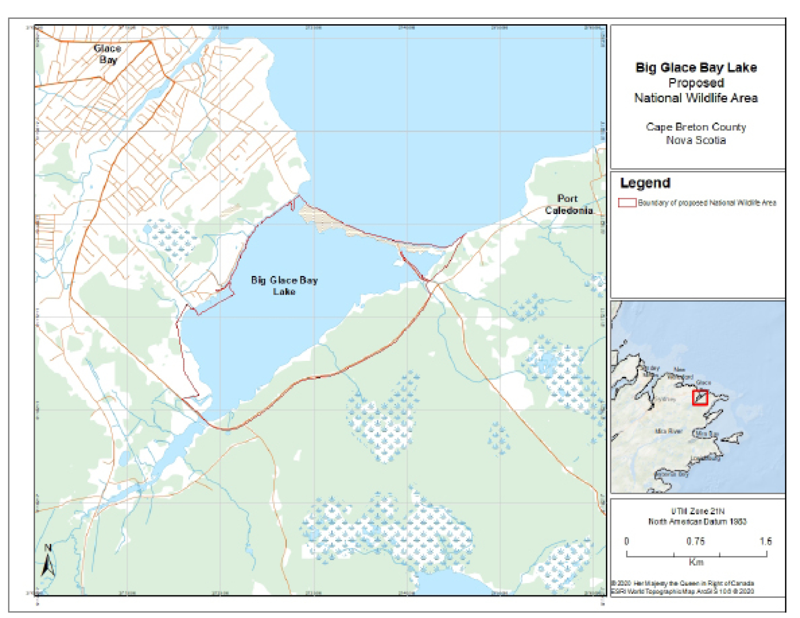
Figure 1 - Text version
Figure 1 is a map showing the location and area of the proposed Big Glace Bay Lake (BGBL) National Wildlife Area (NWA) in the northeast of Cape Breton County, Nova Scotia. This map provides key geographic references, including surrounding permanent waters, main and local roads, as well as the neighbourhoods and streets of the southeastern outskirts of the locality of Glace Bay, which is located to the northwest of the proposed NWA.
Figure 1 shows the boundary of the proposed NWA that includes the area of Big Glace Bay Lake and its beach, and additional parcels of land on the western and southeastern shores of the Lake, but excludes the area of the access road from Port Caledonia to the beach, which cuts across the northeastern corner of the proposed NWA.
In the right-hand sidebar to Figure 1 is a smaller scale map of the northeast of Cape Breton County, pinpointing the location of Big Glace Bay Lake in relationship to the surrounding localities of Sydney, Sydney Mines, New Waterford and Glace Bay to the west, and of Mira River, Mira Bay, Louisbourg and Gabarus Bay to the south.
The intent would be to allow most of the activities that currently occur at the site of the MBS to continue in the new NWA, with the exception of camping, lighting or maintaining a fire, and the possession of lead fishing tackle under 50 g, in order to ensure consistency with the activities allowed in most other NWAs in Canada. Part I of Schedule I.1 of WAR would be amended to include the following allowable activities (which would otherwise be prohibited under the general prohibitions of WAR) for the BGBL NWA:
- wildlife viewing;
- hiking;
- swimming;
- non-commercial picking of edible plants and edible mushrooms;
- boat launching and boat landing in the waters of Big Glace Bay Lake at the terminus of Lake Road (46°10′17.0″ N, 59°57′0.0″ W);
- motorized boating, with a motor of less than 10 horsepower (hp);
- non-motorized boating;
- cross-country skiing and snowshoeing; and
- sport fishing in accordance with any applicable federal permit and any authorization required by the laws of Nova Scotia for sport fishing in that province, during the times authorized by those laws.
Prince Edward Point, Ontario
The proposed Regulations would also add to the existing NWA the two lots of land that form a narrow strip currently separating it into two sections. This would be done by amending WAR through the addition of the land descriptions to the existing PEP NWA description in Part IV of Schedule I.
Figure 2. Map of the proposed additions to the Prince Edward Point National Wildlife Area
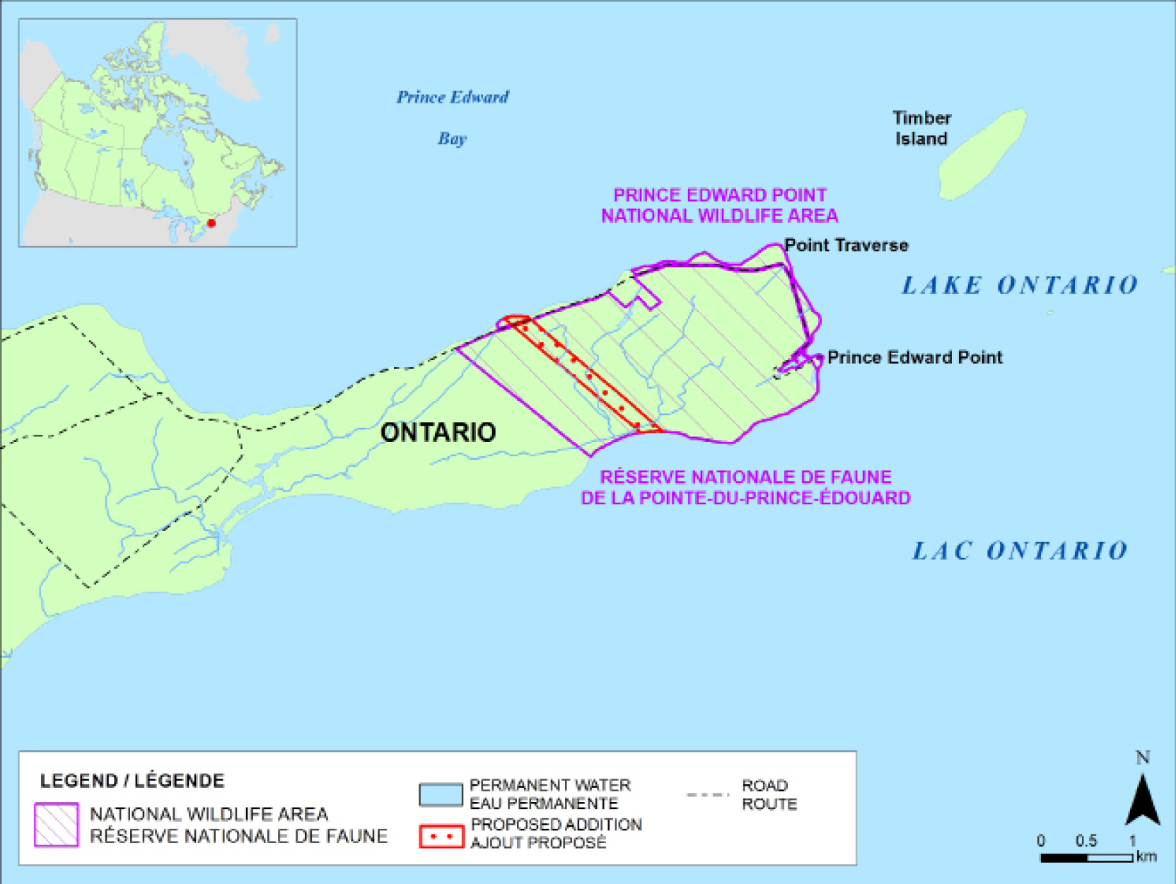
Figure 2 - Text version
Figure 2 is a map showing the location of the existing Prince Edward Point (PEP) National Wildlife Area (NWA) on a peninsula in the northeastern corner of Lake Ontario. This map provides key geographic references, including two main land points (Point Traverse on the northeastern corner of the peninsula and Prince Edward Point towards its southeastern end), Prince Edward Bay to the north of the peninsula and Timber Island to the northeast.
Figure 2 shows the proposed additions to the PEP NWA, two lots of land that form a narrow strip stretching across the width of the peninsula and separating the existing NWA into two sections. It also shows the access road, which is not part of the NWA, and the permanent waters of the peninsula. The road generally follows the northern and northeastern shorelines of the peninsula but moves away from the lake edge in certain of its sections.
At the top left of Figure 2 is a smaller scale map of Canada, showing all of the Canadian provinces and territories and pinpointing the location of the PEP NWA in the southeastern region of the province of Ontario.
The intent would also be to maintain, in the newly added lands, the activities that are currently authorized within the NWA:
- wildlife viewing on designated roads and trails and in designated parking area;
- hiking at the locations referred to in item 1;
- participating in a group meal or group event involving 15 or more people at the locations referred to in item 1;
- operating a vehicle, other than a snowmobile or an all-terrain vehicle, on designated roads and trails and in designated parking areas;
- swimming at designated beach areas;
- boat launching and boat landing at a designated boat launch area;
- boating;
- overnight parking of vehicles, including boat trailers, at the parking lot of a designated boat launch area;
- cross-country skiing and snowshoeing on designated roads and trails and in designated parking areas; and
- sport fishing from the shoreline, in accordance with any applicable federal permit and any authorization required by the laws of Ontario for sport fishing in that province.
Regulatory development
Consultation
Big Glace Bay Lake, Nova Scotia
For the new BGBL NWA, ECCC reached out to 14 Indigenous communities and organizations (including a negotiation office representing 10 of the First Nations among these communities) and 21 stakeholder groups (including conservation organizations and municipal and provincial governments) with respect to the proposed NWA designation and modifications to authorized activities within the proposed NWA.
ECCC sent a consultation package, by email or mail, consisting of a letter outlining the BGBL NWA proposal, together with a map of the proposed NWA and a table of current and proposed allowable activities within the area, to affected First Nations, non-governmental organizations, and provincial and municipal governments. ECCC then followed up, by email or in person, with the groups that had not responded by the specified date, including the negotiation office representing 10 First Nations.
ECCC received responses from one First Nation partner and 11 stakeholders, including 9 conservation organizations, one provincial government department, and one municipality. Overall, the responses received indicated support for the proposed designation of the BGBL area as an NWA. However, a few concerns were raised.
One of the concerns raised was that the creation of the BGBL NWA would prevent access to the beach (located along the northern boundary of the proposed NWA), via the access road from Port Caledonia, known as the “Beach Road.” The original map included in the consultation package indicated that the road was found within the boundaries of the proposed NWA. ECCC sent a follow-up letter to all Indigenous communities and stakeholders, clarifying that it was not intended that the BGBL NWA include this road. The administration and control of this road has been, and will continue to be, the responsibility of the Province of Nova Scotia, through its Department of Transportation and Infrastructure Renewal. Under the proposed Regulations, public pedestrian access to the beach would continue to be allowed and motorized vehicles would not be allowed within the boundaries of the BGBL NWA (as is consistent with the current provincial regulations under the Nova Scotia Beaches Act, which are also in effect at this site). The follow-up letter included a revised map (see Figure 1 above) that excluded the road.
A concern was also raised that the proposed NWA could unintentionally affect commercial fishing in the ocean lots to the north of the beach, which had been proposed as being included within the boundaries of the NWA. ECCC considered this feedback and decided to revise the proposed boundaries of the NWA so that it did not include the marine portion. Given that the key ecological components of the area are located primarily on the BGBL beach and within Big Glace Bay Lake itself, this would not compromise the conservation objectives for the NWA and would allow commercial fishing to continue without the requirement for a permit. The follow-up letter including the revised map (see Figure 1 above) excluded the ocean lots from the area of the proposed NWA.
Concerns were also raised about potential restrictions on the launching and landing of boats, and the use of motorized boats. The follow-up letter also clarified that the proposed Regulations would allow boat launching and landing from a designated terminus, as well as motorized boating, provided the boats are equipped with motors of less than 10 hp, without the need for a permit.
Possible constraints on recreational fishing were also among the concerns raised. The follow-up letter clarified that the proposed Regulations would not restrict recreational fishing, with the exception of the proposed new requirement of using only lead-free tackle under 50 g within the boundaries of the proposed NWA.
Prince Edward Point, Ontario
Prior to the acquisition of the two parcels proposed for addition to the PEP NWA by ECCC, the lands were privately owned, and the owner did not permit their use by others. A short while ago, an inspection by ECCC revealed no visible signs of recent use. Furthermore, the activities authorized or prohibited on these additional lands would be the same under the proposed Regulations as those currently authorized or prohibited under WAR in the adjacent lands already designated as part of the NWA. Therefore, ECCC did not undertake any consultations concerning the expanded PEP NWA prior to publication in the Canada Gazette, Part I.
Modern treaty obligations and Indigenous engagement and consultation
As required by the Cabinet Directive on the Federal Approach to Modern Treaty Implementation, ECCC proceeded with an assessment of the modern treaty implications (AMTI) of the proposed Regulations.
Neither BGBL nor PEP is located within modern treaty areas, and the proposed Regulations would not affect any existing Aboriginal rights. The AMTI did not identify any modern treaty implications in association with creating a new BGBL NWA or adding lands to the existing PEP. It concluded that a detailed assessment is unnecessary. As noted above, ECCC consulted Indigenous groups in the areas surrounding the proposed BGBL NWA. One response was received and it was supportive. For the PEP NWA, a formal consultation process was not undertaken, as the two parcels of land to be added to the NWA were privately held, by an owner who had not permitted their use by others, and an inspection revealed no visible signs of any recent use, including by local Indigenous peoples.
Instrument choice
NWAs are established pursuant to the CWA, to protect and conserve wildlife and wildlife habitat. Section 12 of the CWA authorizes the Governor in Council to make regulations for the preservation, control and management of lands acquired by the Minister of the Environment under the CWA. Regulations are the sole method to manage and effectively protect NWAs in order to ensure the conservation of wildlife and wildlife habitats; therefore, other instruments were not considered.
Regulatory analysis
Benefits
Canada's natural heritage is an integral part of its national identity and history. Canadians value wildlife, in all its forms, for aesthetic, cultural, spiritual, recreational, educational, historic, economic, medical, ecological and scientific reasons.footnote 1
The lots added to the area of the BGBL MBS to form the new BGBL NWA and the lots added to the PEP NWA would together contribute 47.4 hafootnote 2 towards Canada's delivery on its commitment to protect and conserve 25% of its terrestrial areas by 2025.
The proposed Regulations would protect local wildlife species (including species at risk) and their habitats in both the BGBL and PEP areas. The BGBL MBS conserves and protects habitat for several key bird species (e.g. American Black Duck, Canada Goose, Common Goldeneye, Bufflehead) and has been declared critical habitat under SARA for the endangered species of Piping Plover.footnote 3 The PEP NWA conserves and protects habitat for at least 33 protected species under SARA (e.g. birds, butterflies, snakes, bats), including 10 endangered species, and 23 threatened species and species of special concern. Some research suggests that biological diversity enhances the resilience of desirable ecosystem states.footnote 4 Because the wildlife species and habitats in the BGBL and PEP areas are important components of Canada's ecosystems, the proposed Regulations would help promote the biodiversity that contributes to healthy ecosystems, as well as facilitate the management of wildlife and habitat conservation efforts in these areas.
Furthermore, protected areas are important tools for adapting to climate change,footnote 5 through processes such as species protection, genetic diversity promotion, and carbon sequestration in protected habitats. Therefore, the new BGBL NWA and the expanded PEP NWA might also play a role in mitigating certain effects of climate change.
The proposed Regulations would therefore contribute to Canadians benefiting directly and indirectly from the wildlife present in the BGBL and PEP areas and from their habitats, for generations to come.
Costs
There are no economic activities currently taking place within the boundaries of the proposed BGBL NWA or within the proposed additions to the PEP NWA.
There are currently no active exploration licences or mineral leases that affect the proposed BGBL NWA, nor have any such licences or leases affecting this area been issued in the past. Furthermore, a provincial closure applies to lands of the proposed NWA. These closures prevent affected lands from being subject to applications for exploration licences. Even if a closure were lifted, the Nova Scotia Mineral Resources Act (MRA) requires any mineral leaseholder to obtain permission from the relevant landowner before entering lands (including Crown lands) that are subject to the lease. The province has indicated that the closure affecting the BGBL area is not likely to be lifted in the foreseeable future. Even if this closure were to be lifted, the MRA requirements would apply and ECCC would not grant any mineral leaseholder permission to enter the lands of the proposed BGBL NWA. It is therefore very unlikely that any mineral extraction activities would occur in the BGBL area once it has been designated as an NWA.
The proposed Regulations are not anticipated to result in any significant new costs to businesses, consumers or the Canadian public, because the areas and uses of the BGBL and PEP NWAs as proposed do not substantially differ from the areas and uses of the current BGBL MBS and PEP NWA.
ECCC estimates that the proposed Regulations would lead to overall costs for the GC of approximately $169,400footnote 6 (initial set-up, administration and enforcement) for the first year and of approximately $141,700 (administration and enforcement) per year in following years, as delineated below.
For the BGBL NWA, costs would be an additional $2,000 per year. This includes ongoing annual administrative costs, which are slightly greater for an NWA than for an MBS, in an area located several hours in travel distance away from ECCC's regional headquarters. Initial set-up costs for the first year of the BGBL NWA would be an estimated $7,700 for new signage production and installation, travel, staff time and transportation of equipment.
For the PEP NWA, anticipated costs would be an estimated additional $5,000 per year for site administration and contract management. In the first year of the expansion of the PEP NWA, initial set-up costs would approximate $20,000 for additional signage (i.e. for the production and installation of signs at NWA boundaries) and for biological monitoring and habitat management activities (e.g. removal of invasive species). These set-up costs are not expected to be incurred in following years, although they may be spread over two fiscal years depending on the date of publication in the Canada Gazette.
The promotion of compliance through targeted communications to key regulated groups and communities and the development of new web content would give rise to certain modest costs of approximately $2,000 total for both the new BGBL NWA and the expanded PEP NWA.
The incremental cost of enforcement in these areas would be minimal, as monitoring of the existing BGBL MBS and PEP NWA is already required by regulation. Furthermore, the areas and uses of the BGBL and PEP NWAs, as proposed, do not differ substantially from the areas and uses of the current BGBL MBS and PEP NWA.
For the BGBL NWA, the anticipated total annual incremental enforcement costs would be approximately $27,310, based on the resources required for four inspections per year. For the PEP NWA, only a small incremental increase in enforcement costs should be associated with patrolling the two added parcels of land.
Small business lens
There are no small businesses operating in the proposed BGBL NWA or in the proposed expanded PEP NWA. The small business lens does not apply, as the proposed Regulations would not impose any compliance or administrative costs on small businesses.
One-for-one rule
There are no businesses operating in the proposed BGBL NWA or in the proposed PEP NWA expansion. Section 5 of the Red Tape Reduction Act (the “one-for-one” rule) does not apply because the proposed Regulations would not impose any new administrative burden on businesses.
Regulatory cooperation and alignment
The proposed Regulations would not affect the regulatory cooperation and alignment activities of the GC.
Strategic environmental assessment
In accordance with the Cabinet Directive on the Environmental Assessment of Policy, Plan and Program Proposals, a strategic environmental assessment (SEA) was conducted for the proposed establishment of the BGBL NWA and the proposed addition of lands to the PEP NWA. The SEA concluded that the proposed Regulations are not likely to result in important negative environmental effects. The proposed Regulations would have positive environmental effects and would contribute to the implementation of the following 2019–2022 Federal Sustainable Development Strategy goals:
- Sustainably managed lands and forests: Lands and forests support biodiversity and provide a variety of ecosystem services for generations to come. This proposal would contribute to sustainably managed lands and forests within the BGBL and PEP areas.
- Healthy wildlife populations: All species have healthy and viable populations. The BGBL area contains important habitat for several key bird species (e.g. American Black Duck, Canada Goose, Common Goldeneye, Bufflehead) and has been declared critical habitat for Piping Plover, listed under SARA as an endangered species. The PEP NWA contains important habitat for at least 33 species of birds, butterflies, snakes and bats, which are listed under SARA, including 10 in SARA's “endangered” category of risk, and 23 in the “threatened” and “special concern” categories.
- Effective action on climate change: An expanded and strengthened protected areas network would contribute to the larger GC strategy to mitigate and adapt to climate change.
- Connecting Canadians with nature: This proposal would provide increased opportunities for Canadians to experience nature first-hand and inform themselves about the value of nature.
Gender-based analysis plus
A gender-based analysis plus (GBA+) was undertaken. No negative GBA+ impacts have been identified for this proposal. However, the GBA+ suggested some minor positive effects for local Indigenous groups specifically, as a result of increased access to slightly more extensive protected wildlife areas.
Implementation, compliance and enforcement, and service standards
Implementation
Upon establishment of the proposed BGBL NWA and expansion of the PEP NWA, ECCC would continue to be the lead federal organization responsible for compliance promotion and enforcement activities according to the protections provided for under WAR.
Compliance and enforcement
A compliance strategy has been developed to support implementation of the proposed Regulations. Compliance promotion initiatives are proactive measures that encourage voluntary compliance with the law through education and outreach activities that raise awareness and understanding. Given that the proposed Regulations would not impose any significant new requirements, compliance promotion and enforcement activities would be limited and would have a targeted focus. These activities may involve web content, social media, direct mail outs, signage, etc.
The CWA provides wildlife officers (designated under the CWA) with various powers (e.g. inspection, right of passage, search and seizure, custody of things seized) and enforcement measures (compliance orders, tickets, administrative monetary penalties [AMPs] under the Environmental Violations Administrative Monetary Penalties Regulations [EVAMPR] and prosecutions) to secure compliance. The Designation of Regulatory Provisions for Purposes of Enforcement (Canada Wildlife Act) Regulations (the Designation Regulations) designate offences under the CWA that subject an offender to minimum fines and increased maximum fines upon conviction by prosecution.
Enforcement activities are generally prioritized based on conservation risk to wildlife and wildlife habitat, as well as the level of risk of non-compliance. In cases involving minor situations of non-compliance, a warning, compliance order, ticket or AMP may be appropriate. In cases involving a serious incident of non-compliance, prosecution may be the most appropriate recourse for enforcement purposes. In such cases, the fine regime described in the Designation Regulations would apply upon conviction. The Designation Regulations also explain offences and punishments (penalties, fines and imprisonment) for offenders, whether they are individuals, small revenue corporations or other persons. Schedule I.2 of the Contravention Regulations designates offences under the CWA that can subject an offender to a ticket. Schedule 1, Part 2, Division 1 of the EVAMPR designates violations under the CWA that can subject a violator to an AMP.
Contact
Caroline Ladanowski
Director
Wildlife Management and Regulatory Affairs
Canadian Wildlife Service
Environment and Climate Change Canada
351 St. Joseph Boulevard, 16th Floor
Gatineau, Quebec
K1A 0H3
Email: ec.ReglementsFaune-WildlifeRegulations.ec@canada.ca
PROPOSED REGULATORY TEXT
Notice is given that the Administrator in Council proposes to make the annexed Regulations Amending the Wildlife Area Regulations pursuant to section 12footnote a of the Canada Wildlife Actfootnote b.
Interested persons may make representations concerning the proposed Regulations within 30 days after the date of publication of this notice. All such representations must cite the Canada Gazette, Part I, and the date of publication of this notice, and be addressed to Caroline Ladanowski, Director, Wildlife Management and Regulatory Affairs Division, Canadian Wildlife Service, Department of the Environment, 351 Saint-Joseph Boulevard, 16th Floor, Gatineau, Quebec K1A 0H3 (email: ec.ReglementsFaune-WildlifeRegulations.ec@canada.ca).
Ottawa, May 27, 2021
Julie Adair
Assistant Clerk of the Privy Council
Regulations Amending the Wildlife Area Regulations
Amendments
1 Part I of Schedule I to the Wildlife Area Regulationsfootnote 7 is amended by adding the following after item 6:
7 Big Glace Bay Lake National Wildlife Area
All those certain lots, pieces or parcels of land and land covered by water, situated at Glace Bay, Cape Breton Regional Municipality, Province of Nova Scotia, and being described as follows:
PART 1
All that certain lot, piece or parcel of land, situated at or near Donkin-Morien Highway, in the vicinity of Big Glace Bay Lake, Cape Breton Regional Municipality, County of Cape Breton, Province of Nova Scotia, shown as Parcel E on Public Services and Procurement Canada plan S-6073, titled Plan of Survey Showing Parcel D, Parcel E, Parcel F, Parcel G and Parcel H of Lands Deeded to Her Majesty the Queen C/O Atomic Energy of Canada Limited, dated October 15, 2012 as signed by Dennis Prendergast, Nova Scotia Land Surveyor, said plan S-6073 being recorded June 1, 2018 as plan number 112684692 in the Land Registration Office for the County of Cape Breton, said Parcel E being more particularly described as follows:
Beginning at point A situated on the Ordinary High Water Mark of the waters of Big Glace Bay Lake and on a northern boundary of the Donkin-Morien Highway and at the western most point of the hereinafter described Parcel E, as shown on the above mentioned plan, said point A being 77°03′22″, a distance of 3323.74 feet and 309°02′45″, a distance of 189 feet, more or less, from Nova Scotia Control Monument 1557;
Thence along the said northern boundary of the Donkin-Morien Highway, 129°02′45″, a distance of 189 feet, more or less, to a calculated point;
Thence continuing along the said northern boundary of the Donkin-Morien Highway and following along the arc of a curve to the left having a radius of 1015.54 feet for an arc distance of 155.72 feet to a calculated point, said calculated point being 124°39′11″, a distance of 155.57 feet from the last mentioned calculated point;
Thence continuing along the said northern boundary of the Donkin-Morien Highway, 120°24′03″, a distance of 5.11 feet to a calculated point;
Thence continuing along the said northern boundary of the Donkin-Morien Highway and following along the arc of a curve to the left having a radius of 1007.65 feet for an arc distance of 498.57 feet to a calculated point, said calculated point being 106°05′07″, a distance of 493.50 feet from the last mentioned calculated point;
Thence continuing along the said northern boundary of the Donkin-Morien Highway, 91°54′39″, a distance of 5.21 feet to a calculated point;
Thence continuing along the said northern boundary of the Donkin-Morien Highway and following along the arc of a curve to the left having a radius of 970.89 feet for an arc distance of 405.29 feet to a calculated point, said calculated point being 79°57′07″, a distance of 402.35 feet from the last mentioned calculated point;
Thence continuing along the said northern boundary of the Donkin-Morien Highway and following along the arc of a curve to the left having a radius of 1117.71 feet for an arc distance of 285.19 feet to a calculated point, said calculated point being 60°41′00″, a distance of 284.42 feet from the last mentioned calculated point;
Thence continuing along the said northern boundary of the Donkin-Morien Highway, 53°22′26″, a distance of 832.93 feet to a calculated point;
Thence continuing along the said northern boundary of the Donkin-Morien Highway and following along the arc of a curve to the left having a radius of 2849.60 feet for an arc distance of 483.24 feet to a calculated point, said calculated point being 48°30′57″, a distance of 482.66 feet from the last mentioned calculated point;
Thence continuing along the said northern boundary of the Donkin-Morien Highway, 43°39′28″, a distance of 754.37 feet to a calculated point (AA);
Thence continuing along the said northern boundary of the Donkin-Morien Highway and following along the arc of a curve to the left having a radius of 1398.57 feet for an arc distance of 893.31 feet to a calculated point (BB), said calculated point (BB) being 61°57′22″, a distance of 878.21 feet from the last mentioned calculated point (AA);
Thence continuing along the said northern boundary of the Donkin-Morien Highway, 80°15′16″, a distance of 493.29 feet to a calculated point;
Thence continuing along the said northern boundary of the Donkin-Morien Highway and following along the arc of a curve to the left having a radius of 1410.65 feet for an arc distance of 514.28 feet to a calculated point, said calculated point being 69°48′37″, a distance of 511.44 feet from the last mentioned calculated point;
Thence continuing along the said northern boundary of the Donkin-Morien Highway, 59°21′58″, a distance of 1120.63 feet to a calculated point;
Thence continuing along the said northern boundary of the Donkin-Morien Highway and following along the arc of a curve to the left having a radius of 5917.84 feet for an arc distance of 150.42 feet to a calculated point, said calculated point being 58°38′17″, a distance of 150.42 feet from the last mentioned calculated point;
Thence continuing along the said northern boundary of the Donkin-Morien Highway, 57°54′35″, a distance of 528.04 feet to a calculated point;
Thence continuing along the said northern boundary of the Donkin-Morien Highway and following along the arc of a curve to the left having a radius of 1879.58 feet for an arc distance of 623.70 feet to a calculated point, said calculated point being 48°24′12″, a distance of 620.84 feet from the last mentioned calculated point;
Thence along the northwestern boundary of the said Donkin-Morien Highway, 38°53′49″, a distance of 460.39 feet to a calculated point;
Thence continuing along the said northwestern boundary of the Donkin-Morien Highway and following along the arc of a curve to the left having a radius of 5917.84 feet for an arc distance of 296.91 feet to a calculated point, said calculated point being 36°59′01″, a distance of 296.88 feet from the last mentioned calculated point;
Thence along the northwestern boundary of the said Donkin-Morien Highway, 35°04′12″, a distance of 407.97 feet to a calculated point;
Thence continuing along the said northwestern boundary of the Donkin-Morien Highway and following along the arc of a curve to the left having a radius of 5119.09 feet for an arc distance of 667.64 feet to a survey marker situated on a western boundary of PID 15281793, lands now or formerly of Ronnie Dearn Fuels Ltd, said survey marker being 31°18′37″, a distance of 667.17 feet from the last mentioned calculated point;
Thence along the said western boundary of PID 15281793, lands now or formerly of Ronnie Dearn Fuels Ltd, 336°49′50″, a distance of 126.02 feet to a survey marker situated on a western boundary of PID 15498447, lands now or formerly of Fred Murrant;
Thence along the said western boundary of PID 15498447, lands now or formerly of Fred Murrant, 336°49′50″, a distance of 401.98 feet to a survey marker;
Thence 43°34′50″, a distance of 898.06 feet to a survey marker;
Thence 156°49′50″, a distance of 164.90 feet to a survey marker situated on a northwestern boundary of the Old Donkin Highway;
Thence along the said northwestern boundary of the Old Donkin Highway, 17°57′10″, a distance of 128.64 feet to a calculated point;
Thence continuing along the said northwestern boundary of the Old Donkin Highway and following along the arc of a curve to the right having a radius of 3692.48 feet for an arc distance of 486.54 feet to a calculated point, said calculated point being 21°43′37″, a distance of 486.18 feet from the last mentioned calculated point;
Thence along the said northwestern boundary of the Old Donkin Highway, 25°30′04″, a distance of 392.77 feet to a calculated point (D) situated on the Ordinary High Water Mark of the waters of the Atlantic Ocean;
Thence following along the said Ordinary High Water Mark of the waters of the Atlantic Ocean in a generally westerly direction, for a distance of 6130 feet, more or less, to a calculated point (C) situated on the eastern shore of a channel and being a western point of a peninsula of land between the waters of the Atlantic Ocean and the waters of Big Glace Bay Lake;
Thence following along the various sinuosities, including and along the extremities of any lagoons, ponds or marshes of the said Big Glace Bay Lake and following along the Ordinary High Water Mark of waters of Big Glace Bay Lake a distance of 7480 feet, more or less, to a point (B);
Thence following along the various sinuosities of the Ordinary High Water Mark of waters of Big Glace Bay Lake in a generally southwesterly direction for a distance of 10,630 feet, more or less, to the place of beginning.
Together with and including all and any islands, ponds, wetlands and watercourses.
Saving and excepting thereout and therefrom all public roads including any and all portions of the former highway from Glace Bay to Port Morien (now commonly referred to as Beach Road).
The above described Parcel E contains an area of 268 acres, more or less (including islands).
All azimuths are grid-referenced to longitude 61°30′W, the central meridian of Zone 4, MTM projection, ATS77 metric values.
PART 2
All that certain lot, piece or parcel of land, situated at or near Donkin-Morien Highway and Lake Road, in the vicinity of Big Glace Bay Lake, Town of Glace Bay, Cape Breton Regional Municipality, County of Cape Breton, Province of Nova Scotia, shown as Parcel 2016-1 (PID 15881246) on Public Services and Procurement Canada plan S-6001, titled Plan of Survey Showing Parcels 2016-1, 2016-2, 2016-3, 2016-4, 2016-5 and 2016-6, Land of H.M. in right of Canada, dated November 23, 2016 as signed by Dennis Prendergast, Nova Scotia Land Surveyor, said plan S-6001 being recorded November 25, 2016 as plan number 109952649 in the Land Registration Office for the County of Cape Breton, said Parcel 2016-1 being more particularly described as follows:
Beginning at a point (A) situated on the northeastern boundary of the Donkin-Morien Highway near the northwestern end of a bridge over the waters between MacAskills Brook and Big Glace Bay Lake, and on the Ordinary High Water Mark of the waters of Big Glace Bay Lake and at the southernmost corner of the hereinafter described Parcel 2016-1;
Thence following along the said Ordinary High Water Mark of the waters of Big Glace Bay Lake in a generally northeasterly direction for a distance of 880 feet, more or less, to a calculated point (B);
Thence continuing along the said Ordinary High Water Mark of the waters of Big Glace Bay Lake in a generally northwesterly direction for a distance of 1850 feet, more or less, to a calculated point (C) situated on the southern boundary of Parcel 2016-2, lands now or formerly of H.M. in right of Canada, said point (C) being 87°57′03″, a distance of 30 feet, more or less, from a survey marker;
Thence along the said southern boundary of Parcel 2016-2, lands now or formerly of H.M. in right of Canada, 267°57′03″, a distance of 30 feet, more or less, to a survey marker, said survey marker being 330°11′27″, a distance of 1695.38 feet from aforementioned point (B);
Thence along the said southern boundary of Parcel 2016-2, lands now or formerly of H.M. in right of Canada and continuing 267°57′03″, a distance of 160.95 feet to a survey marker;
Thence along the southwestern boundary of said Parcel 2016-2, lands now or formerly of H.M. in right of Canada, 322°44′48″, a distance of 91.08 feet to a survey marker;
Thence along the southern boundary of said Parcel 2016-2, lands now or formerly of H.M. in right of Canada, 254°24′57″, a distance of 46.17 feet to a survey marker;
Thence along the southwestern boundary of said Parcel 2016-2, lands now or formerly of H.M. in right of Canada, 345°11′43″, a distance of 104.61 feet to a survey marker;
Thence along the southern boundary of said Parcel 2016-2, lands now or formerly of H.M. in right of Canada, 253°38′53″, a distance of 80.23 feet to a survey marker situated on the eastern boundary of Parcel 2016-4, lands now or formerly of H.M. in right of Canada;
Thence along the said eastern boundary of Parcel 2016-4, lands now or formerly of H.M. in right of Canada, 163°57′43″, a distance of 488.36 feet to a survey marker;
Thence along the said eastern boundary of Parcel 2016-4, lands now or formerly of H.M. in right of Canada, 209°48′34″, a distance of 72.22 feet to a survey marker;
Thence along the said eastern boundary of Parcel 2016-4, lands now or formerly of H.M. in right of Canada, 164°48′34″, a distance of 300.00 feet to a survey marker situated on the eastern boundary of Parcel 2016-5, lands now or formerly of H.M. in right of Canada;
Thence along the said eastern boundary of Parcel 2016-5, lands now or formerly of H.M. in right of Canada, 145°15′04″, a distance of 894.36 feet to a survey marker;
Thence along the southern boundary of Parcel 2016-5, lands now or formerly of H.M. in right of Canada, 254°43′21″, a distance of 589.04 feet to a survey marker situated on the aforesaid northeastern boundary of the Donkin-Morien Highway;
Thence along the said northeastern boundary of the Donkin-Morien Highway, 129°02′45″, a distance of 827.17 feet to a survey marker;
Thence continuing along the said northeastern boundary of the Donkin-Morien Highway, 129°02′45″, a distance of 125 feet, more or less, to the place of beginning.
The above described Parcel 2016-1 contains an area of 28 acres, more or less (including beach area).
All azimuths are grid-referenced to longitude 61°30′W, the central meridian of Zone 4, MTM projection, ATS77 metric values.
PART 3
All that certain lot, piece or parcel of land, situated at or near Donkin-Morien Highway and Lake Road, in the vicinity of Big Glace Bay Lake, Town of Glace Bay, Cape Breton Regional Municipality, County of Cape Breton, Province of Nova Scotia, shown as Parcel 2016-2 (PID 15881253) on Public Services and Procurement Canada plan S-6001, titled Plan of Survey Showing Parcels 2016-1, 2016-2, 2016-3, 2016-4, 2016-5 and 2016-6, Land of H.M. in right of Canada, dated November 23, 2016 as signed by Dennis Prendergast, Nova Scotia Land Surveyor, said plan S-6001 being recorded November 25, 2016 as plan number 109952649 in the Land Registration Office for the County of Cape Breton, said Parcel 2016-2 being more particularly described as follows:
Beginning at a point (C) situated on the northern boundary of Parcel 2016-1, lands now or formerly of H.M. in right of Canada, and on the Ordinary High Water Mark of the waters of Big Glace Bay Lake and at the southeastern-most corner of the hereinafter described Parcel 2016-2, as shown on the above mentioned plan, said point (C) being 87°57′03″, a distance of 30 feet, more or less, from a survey marker;
Thence along the said northern boundary of Parcel 2016-1, lands now or formerly of H.M. in right of Canada, 267°57′03″, a distance of 30 feet, more or less, to a survey marker;
Thence along the said northern boundary of Parcel 2016-1, lands now or formerly of H.M. in right of Canada, and continuing 267°57′03″, a distance of 160.95 feet to a survey marker;
Thence along the northeastern boundary of said Parcel 2016-1, lands now or formerly of H.M. in right of Canada, 322°44′48″, a distance of 91.08 feet to a survey marker;
Thence along the northern boundary of said Parcel 2016-1, lands now or formerly of H.M. in right of Canada, 254°24′57″, a distance of 46.17 feet to a survey marker;
Thence along the northeastern boundary of said Parcel 2016-1, lands now or formerly of H.M. in right of Canada, 345°11′43″, a distance of 104.61 feet to a survey marker;
Thence along the northern boundary of said Parcel 2016-1, lands now or formerly of H.M. in right of Canada, 253°38′53″, a distance of 80.23 feet to a survey marker situated on the eastern boundary of Parcel 2016-3, lands now or formerly of H.M. in right of Canada;
Thence along the said eastern boundary of Parcel 2016-3, lands now or formerly of H.M. in right of Canada, 345°45′32″, a distance of 962.86 feet to a survey marker situated on the southeastern boundary of PID 15872468, lands now or formerly of Cape Breton Regional Municipality;
Thence along the said southeastern boundary of PID 15872468, lands now or formerly of Cape Breton Regional Municipality, 26°46′27″, a distance of 771.03 feet to a survey marker situated on the southwestern boundary of Lake Road;
Thence along the said southwestern boundary of Lake Road, 134°07′52″, a distance of 181.04 feet to a survey marker;
Thence along the said southwestern boundary of Lake Road, 161°35′21″, a distance of 75 feet, more or less, to a point (D) situated on the aforesaid Ordinary High Water Mark of the waters of Big Glace Bay Lake;
Thence following along the said Ordinary High Water Mark of the waters of Big Glace Bay Lake in a generally southerly direction for a distance of 1830 feet, more or less, to the place of beginning.
The above described Parcel 2016-2 contains an area of 7 acres, more or less.
All azimuths are grid-referenced to longitude 61°30′W, the central meridian of Zone 4, MTM projection, ATS77 metric values.
PART 4
All that certain parcel of land and land covered with water situated in the vicinity of Big Glace Bay Lake and lying partly in the Town of Glace Bay and within the County of Cape Breton, Province of Nova Scotia and being comprised of that land and land covered with water shown on a plan titled Showing Lands to be Expropriated by the Province of Nova Scotia for the Purpose of Encouraging the Development of Industry within the Province of Nova Scotia, signed by Walter E. Servant, P.L.S., dated July 15, 1964, said plan being recorded October 29, 1964 as Expropriation Plan GB138 and which said lands may be more particularly described as follows:
Beginning at a point on the eastern boundary of the 40-foot wide Lake Road, said point being S19°25′E a distance of 596.8 feet from the intersection of the eastern boundary of the said Lake Road with the northern boundary of Victory Road, so called, the said northern boundary being also the southern boundary of lands granted to one Elizabeth Hilliard;
Thence S19°25′E for a distance of 960 feet to a point approximately 300 feet into Big Glace Bay Lake from the northern shore of the said lake;
Thence N76°39.5′E 1453.3 feet to a point;
Thence N21°46′W 300 feet to the northern shore line of Big Glace Bay Lake;
Thence following the various courses of said shore line at high water mark a straight line bearing of N46°44.5′E 1761.8 feet to the eastern boundary of property now or formerly of Seaboard Power Corporation;
Thence N21°46′W a distance of 823 feet to the southern boundary of lands granted to one Elizabeth Hilliard;
Thence N68°14′E along the southern boundary of said Grant to Elizabeth Hilliard, 1857.4 feet;
Thence S13°51.3′W 797.3 feet to a point;
Thence N76°21.3′E for a distance of 1001 feet;
Thence N64°E for a distance of 610.3 feet;
Thence S26°E for a distance of 220 feet to the shore of Big Glace Bay at high water mark;
Thence northeasterly along the various courses of the said shore at high water mark for a straight line bearing of N16°50.3′E for a distance of 300 feet;
Thence N68°14′E into the waters of Big Glace Bay for a distance of 1380 feet along the northern boundary line of a water lot formerly granted to Joseph H. Converse to the northeastern corner of the said water lot;
Thence S44°51.2′E for a distance of 4468.7 feet to the northeastern corner of a water lot granted to Caledonia Coal Mining Company and Clyde Coal Mining Company;
Thence S03°10′W along the eastern boundary of the said water lot for distance of 1525 feet to the northern boundary of the former Public Highway leading to Dominion No. 6;
Thence along the various courses of the northern boundary of the said Public Highway, N84°W for a distance of 149.8 feet, S68°W for a distance of 381 feet, S52°35.5′W for a distance of 719.7 feet, and S45°21.4′W for a distance of 415.3 feet;
Thence N3°10′E for a distance of 175.6 feet;
Thence S69°55′W for a distance of 933 feet;
Thence S3°10′W for a distance of 528 feet to the northern boundary of the public highway leading from Glace Bay to Donkin;
Thence along the various courses of the northern boundary of the said highway, S57°15.7′W 359.5 feet, S60°59.7′W 527.7 feet, S63°03.7′W 350 feet, and S65°44.9′W 425.5 feet to the beginning of a curve in the said highway boundary;
Thence southwesterly along the said curve a distance of 780.8 feet to the end of said curve;
Thence S85°27.3′W along the northern boundary of the said highway for a distance of 1661.1 feet;
Thence crossing the said highway S14°02.4′W for a distance of 69.5 feet to the intersection of the southern boundary of the above mentioned public highway with the northern boundary of the now abandoned Tower Road;
Thence following the various courses of the northern boundary of Tower Road, so called, S67°31.7′W for a distance of 1000.7 feet, and S65°17′W 870.8 feet to the beginning of a curve;
Thence westerly along a curve in the said northern boundary for a distance of 369.3 feet to the end of said curve;
Thence S83°35.2′W for a distance of 741.8 feet along the northern boundary of Tower Road to an angle therein;
Thence N88°35′W for a distance of 691.6 feet to the intersection of the said northern boundary of Tower Road with the eastern boundary of the public road leading to Sand Lake;
Thence crossing the said public road leading to Sand Lake, N88°35′W for a distance of 74.2 feet to the intersection of the northern boundary of Tower Road with the western boundary of the public road leading to Sand Lake;
Thence N88°25.4′W for a distance of 527.8 feet along the northern boundary of Tower Road to the beginning of a curve to the right;
Thence westerly along said curve to the right for a distance of 116.1 feet to the end of said curve;
Thence westerly along a curve to the left for a distance of 410.5 feet to the end of said curve;
Thence along the various courses of the northern boundary of Tower Road, S66°34.8′W 581.5 feet, S68°57.3′W 663.1 feet, S74°53′W 400 feet and S78°07.4′W 525.6 feet to the beginning of a curve;
Thence westerly along the said curve on the northern boundary of Tower Road for a distance of 694 feet to the end of said curve;
Thence N70°00.8′W 472.2 feet along the said northern boundary of Tower Road to intersect the eastern boundary of the Sydney and Louisbourg Railway Right of Way;
Thence northerly along a curve in the eastern boundary of the said Sydney and Louisbourg Railway Right of Way for a distance of 810.7 feet;
Thence N2°41.3′W along the said Right of Way boundary for a distance of 2522.3 feet;
Thence N87°18.7′E for a distance of 329.2 feet;
Thence N24°28.4′W for a distance of 887.1 feet to the eastern boundary of the Sydney and Louisbourg Railway Right of Way;
Thence N2°41.3′W along the said Right of Way boundary for a distance of 2041.6 feet;
Thence S24°28.4′E for a distance of 301.1 feet;
Thence N64°37.4′E for a distance of 777.6 feet to the western boundary of the public highway leading from Glace Bay to Donkin;
Thence N64°37.4′E for a distance of 66 feet to the eastern boundary of the said public highway;
N64°37.4′E for a distance of 1544.4 feet;
Thence S22°23′E for a distance of 222 feet;
Thence N69°37′E for a distance of 663.1 feet;
Thence S21°46′E for a distance of 649.8 feet;
Thence N 68°14′E for a distance of 516.3 feet to the western boundary of Lake Road, so called;
Thence S19°25′E along the western boundary of Lake Road for a distance of 515.2 feet;
Thence N70°35′E crossing Lake Road for a distance of 40 feet to the place of beginning.
Saving and excepting from the lands hereinbefore described the following:
All portions of the above described land, which lie above the ordinary high water mark of Big Glace Bay Lake and the ordinary high water mark of the Atlantic Ocean;
All portions of the above described land and land covered by water, which lie to the west of the Donkin-Morien Public Highway where it crosses MacAskills Brook, including any portion of MacAskills Brook and any portion of the said Public Highway;
All portions of water lots described in the Deed to the Province of Nova Scotia in Book 1888 at Page 449;
Being and intended to comprise all of the waters of Big Glace Bay Lake and all of the remaining waters of Big Glace Bay which are contained within the Expropriation shown on a plan titled Showing Lands to be Expropriated by the Province of Nova Scotia for the Purposes of Encouraging the Development of Industry within the Province of Nova Scotia, signed by Walter E. Servant, P.L.S., dated July 15, 1964 and filed February 10, 1978 at the Registry of Deeds in Sydney, Nova Scotia as Plan No. M1373E,
Saving and excepting from the above described all those lands covered by water lying north and east of the Ordinary Low Water Mark of the waters of Glace Bay.
2 (1) The first paragraph of item 8 of Part IV of Schedule I to the Regulations is replaced by the following:
Being all those parcels of land, in the County of Prince Edward, in the Township of South Marysburgh, being more particularly described under Firstly to Eighthly as follows:
(2) The last paragraph of item 8 of Part IV of Schedule I to the Regulations is replaced by the following:
Seventhly, that parcel of land described under PIN 55091-0178(LT) as Part of Lot 8, Concession Long Point, South Marysburgh as in PE26106 South of Long Point Road, Prince Edward County;
Eighthly, that parcel of land described under PIN 55091-0179(LT) as Part of Lot 8, Concession Long Point, South Marysburgh as in PE26106 North of Long Point Road, Prince Edward County;
Said parcels containing together about 546.3 hectares.
3 Part I of Schedule I.1 to the Regulations is amended by adding the following at the end of that Part:
Big Glace Bay Lake National Wildlife Area
- 1 Wildlife viewing
- 2 Hiking
- 3 Swimming
- 4 Non-commercial picking of edible plants and edible mushrooms
- 5 Boat launching and boat landing in the waters of Big Glace Bay Lake at the terminus of the Lake Road (46°10′17.0″N, 59°57′0.0″W)
- 6 Motorized boating, with a motor of less than 10 horsepower
- 7 Non-motorized boating
- 8 Cross-country skiing and snowshoeing
- 9 Sport fishing in accordance with any applicable federal permit and any authorization required by the laws of Nova Scotia for sport fishing in that province, during the periods authorized by those laws
- 10 Activities referred to in items 1 to 9 from sunset to sunrise, in addition to during the period referred to in subsection 3.1(3)
Coming into Force
4 These Regulations come into force on the day on which they are registered.
Privacy notice statement
Provision of the information is on a voluntary basis. We will use the information for the purpose of responding to your questions/comments, and to improve our Internet presence. The information will be held in Public Services and Procurement Canada's Personal Information Bank number PPU 115 Internet and PPE 830 intranet Services, and it will be retained according to the retention and disposal schedule established for this bank.
Your personal information is protected under the provisions of the Privacy Act. Under the Act, you have the right to request access to and correction of your personal information, if erroneous or incomplete. If you wish to avail yourself of this right or require clarification about this statement, contact our Privacy Coordinator at aiprp.atip@tpsgc-pwgsc.gc.ca. For more information on privacy issues and the Privacy Act consult the Office of the Privacy Commissioner of Canada.
For more information about your rights, visit Info Source. This is a Government of Canada publication available in major libraries, at government information offices and from constituency offices of federal Members of Parliament.
The Internet is a public forum and electronic information can be intercepted. This is not a secure website. Please do not disclose unnecessary confidential information about yourself or your accounts with Public Services and Procurement Canada.