Canada Gazette, Part I, Volume 156, Number 26: Supplement 1
June 25, 2022
FEDERAL ELECTORAL BOUNDARIES COMMISSION FOR THE PROVINCE OF ALBERTA
Proposal of the Federal Electoral Boundaries Commission for the Province of Alberta
Introduction
The Federal Electoral Boundaries Commission for the Province of Alberta (“the Commission”) has been established pursuant to the Electoral Boundaries Readjustment Act, R.S.C. 1985, c. E-3, as amended (“the Act”).
The Canadian Constitution requires a readjustment of the total number of members of the House of Commons and of each province following each decennial census. The formula and rules provided in sections 51 and 51A of the Constitution Act, 1867 (“the Constitution”) govern this readjustment. As a result, federal electoral boundaries must be adjusted every 10 years to accommodate new electoral districts, and the population shifts and changes within the province, since the previous decennial census.
The Act requires the establishment of an independent, three-person Commission in each province to define the sizes, boundaries and names of the electoral districts within that province. The Chief Justice of a province appoints the Chair of the Commission, and the Speaker of the House of Commons appoints the other two members.
The Commission for Alberta was established by Order-in-Council, proclaimed on November 1, 2021. The Chair of the Commission is Justice J.D. Bruce McDonald, of the Court of Appeal of Alberta. The other members are Dr. Donald Barry of Calgary, Professor Emeritus of Political Science, University of Calgary; and Ms. Donna R. Wilson of Edmonton, an election specialist and a former federal returning officer.
Alberta’s population count increased from 3,645,257 to 4,262,635 between the 2011 and the 2021 censuses. Application of the formula and rules contained in the Constitution resulted in an increase in the total number of seats in the House of Commons from 338 to 342 and an increase in the total number assigned to Alberta from 34 to 37.
The electoral quota for each Alberta electoral district is 115,206. This number is obtained by dividing the 2021 Alberta census population count of 4,262,635 by 37, the number of House of Commons seats allocated to the province. Alberta has the third-highest electoral quota in Canada after Ontario (116,590) and British Columbia (116,300).
Principles Governing the Commission
When readjusting the electoral boundaries, the Commission is governed by the principles set out in the Act. Section 15(1)(a) of the Act provides that the division of the province into electoral districts, and the description of the boundaries, shall proceed on the basis that the population of each electoral district shall, as closely as reasonably possible, correspond to the electoral quota for the province.
Section 15(1)(b) of the Act provides that the Commission shall also consider the following two criteria:
- the community of interest or community of identity in, or the historical pattern of, an electoral district in the province; and
- a manageable geographic size for districts in sparsely populated, rural or northern regions of the province.
The Commission may deviate from strict electoral parity where it considers it necessary or desirable to do so in order to respect or maintain these criteria, provided that deviation from the provincial quota shall exceed 25% more or less, only in circumstances that the Commission considers extraordinary (subsection 15(2) of the Act).
With an electoral quota of 115,206, it follows that, absent extraordinary circumstances, Alberta’s electoral districts should not exceed a maximum population of 144,008 or a minimum population of 86,405.
In summary, the overarching principle of the Act is to ensure that each electoral district shall, as closely as reasonably possible, correspond to the electoral quota for the province, often referred to as population parity. When drawing the boundaries, the Commission must consider communities of interest or identity, historical patterns and geographic size. Where the Commission determines that it is either necessary or desirable to deviate from population parity, it has the discretion to do so within the limits set out in the Act.
Statement of Process for Adjusting Boundaries
The process for readjustment of electoral boundaries can be briefly summarized.
The Commission prepares the boundaries of electoral districts, which are contained in a proposed redistribution plan. Advertisements in the Canada Gazette and in at least one newspaper of general circulation will include a map showing the proposed electoral districts and provide notice of the time and place fixed for public hearings. Notice of intention to make representations on the proposed electoral districts must be given in writing to the Commission within 23 days of the publication of the last advertisement. The rules governing representations at a public hearing are contained in “Rules for Public Hearings” later in this proposal.
Following the public hearings, the Commission reviews its proposed redistribution plan, makes revisions and submits its final report to the Chief Electoral Officer of Canada. In Alberta, the final report is due by December 15, 2022.
The Commission’s report is then sent to the House of Commons, where it is referred to a parliamentary committee. Once considered, it is sent back to the Commission. The Commission considers any objections, makes any modifications it deems necessary and provides a final, certified copy of its report to the Chief Electoral Officer of Canada, with or without amendment. Upon receipt of the reports from all provinces, a draft order (referred to as the representation order) is prepared, describing and naming the electoral districts established by all the Commissions.
Within five days of the Minister receiving the representation order, the Governor-in-Council shall proclaim the order in force, effective on the first dissolution of Parliament that occurs at least seven months after the day on which the proclamation was issued. Thus, the new boundaries can be used only for a general election called at least seven months after the representation order is proclaimed.
Proposed Boundaries
Overview and Explanations
According to census figures, Alberta’s population grew from 3,645,257 in 2011 to 4,262,635 in 2021. Most of the increase took place in Alberta’s two largest cities and nearby communities, with some rural electoral districts recording gains and others moderate declines. Population changes and the addition of three new electoral districts required adjustments to every electoral district in Alberta. In approaching its task, the Commission has been guided by the need to create electoral districts as close to the provincial quota of 115,206 as is reasonably possible, taking account of communities of interest and identity, historical patterns and geographic size.
The Commission has not found any extraordinary circumstances that would justify deviating from the electoral quota by more than 25%. All of the proposed electoral districts are within 5% of the quota. The largest proposed electoral district has a population of 120,917, or 4.96% over the quota. The smallest has a population of 110,350, or 4.22% under the quota.
The Commission has been governed by its constitutional and statutory obligations in preparing its proposed redistribution plan. As required by section 15 of the Act, the Commission considered the geographic size, community of interest or community of identity in, and the historical pattern of, each electoral district in determining whether deviation from the electoral quota was either necessary or desirable. The Commission considered the topography of each electoral district and the impact of its geographic size on the representation of any electoral district, particularly in the northern and less populated areas.
Ms. Olivia Mancuso, a skilled geography specialist, worked with the Commission. In addition, the Commission had access to data from the Department of Natural Resources and the Chief Statistician of Canada. Population figures are based on the 2021 census, as provided by Statistics Canada. The Commission considered existing federal electoral districts, provincial electoral districts, and county and municipal boundaries, and it made efforts to follow such boundaries where convenient and considered desirable.
By use of its website, the Commission invited comments and suggestions from the public. This was not intended as a substitute for the full public hearings, which will occur following publication of this proposed redistribution plan. The Commission appreciates the many comments, maps and recommendations received. These comments identified many issues, which were discussed and considered.
In determining the names of the electoral districts, the Commission wanted them to reflect an identifying physical or historical site, object or geographical feature within their boundaries. Many of the existing names were retained. However, following the federal guidelines, where an electoral district was substantially altered, a new name was selected.
The Commission welcomes full input from Albertans at the public hearings, following which it will prepare its final report in accordance with its constitutional and statutory mandate.
Proposed Electoral Districts
The Commission proposes 37 electoral districts for Alberta, listed in the table below.
| Electoral District | Population (2021) |
Deviation from Quota of 115,206 |
|---|---|---|
| Airdrie—Chestermere | 113,312 | –1.64% |
| Battle River—Crowfoot | 115,242 | +0.03% |
| Bow River | 115,937 | +0.64% |
| Calgary Centre | 119,822 | +4.01% |
| Calgary Confederation | 119,070 | +3.35% |
| Calgary Crowchild | 117,541 | +2.03% |
| Calgary Forest Lawn | 119,626 | +3.84% |
| Calgary Heritage | 119,361 | +3.61% |
| Calgary McKnight | 119,404 | +3.64% |
| Calgary Midnapore | 118,890 | +3.20% |
| Calgary Nose Hill | 118,822 | +3.14% |
| Calgary Shepard | 115,093 | –0.10% |
| Calgary Signal Hill | 120,917 | +4.96% |
| Calgary Skyview | 118,238 | +2.63% |
| Canmore—Cochrane—Olds | 110,350 | –4.22% |
| Edmonton Centre | 111,183 | –3.49% |
| Edmonton Gateway | 110,524 | –4.06% |
| Edmonton Griesbach | 113,913 | –1.12% |
| Edmonton Manning | 111,039 | –3.62% |
| Edmonton Mill Woods | 113,208 | –1.73% |
| Edmonton Riverbend | 113,181 | –1.76% |
| Edmonton Strathcona | 111,580 | –3.15% |
| Edmonton West | 112,948 | –1.96% |
| Edmonton Winterburn | 113,323 | –1.64% |
| Foothills | 115,857 | +0.57% |
| Fort McMurray—Cold Lake | 110,779 | –3.84% |
| Grande Prairie | 112,902 | –2.00% |
| Lakeland | 115,854 | +0.56% |
| Lethbridge | 115,008 | –0.17% |
| Medicine Hat—Cardston—Warner | 117,447 | +1.95% |
| Peace River—Westlock | 114,091 | –0.97% |
| Red Deer | 113,734 | –1.28% |
| Sherwood Park—Beaumont | 115,265 | +0.05% |
| Spruce Grove—Leduc | 116,543 | +1.16% |
| Sturgeon River | 114,803 | –0.35% |
| Wetaskiwin—Lacombe | 115,563 | +0.31% |
| Yellowhead | 112,265 | –2.55% |
Detailed Descriptions
The Appendix of this proposal contains a detailed description and map for each proposed electoral district.
General Comments on Regions
City of Calgary
Calgary’s population grew from 1,096,833 in 2011 to 1,306,784 in 2021; this represents an increase of 19.14%. While some of the city’s electoral districts grew moderately or declined slightly, the remaining districts experienced substantial growth. Accommodating these changes required adjustments to the boundaries of all electoral districts in Calgary. The Commission proposes that the number of electoral districts be increased from 10 to 11, with an average population of 118,799, or 3.12% above Alberta’s electoral quota. The Commission finds this increase acceptable and in line with the recommendations of earlier commissions. Reflecting Calgary’s long-standing community of interest, all the electoral districts are located within the boundaries of the City.
The Commission considered and rejected the idea of increasing the number of the City’s electoral districts to 12. Were this to be done, the average population of each district would be 108,899, or 5.48% below the province’s electoral quota, which the Commission considers inappropriate.
The populations of the Calgary Nose Hill, Calgary Confederation, Calgary Centre and Calgary Signal Hill electoral districts sustained moderate increases between 2011 and 2021. The Commission proposes that the northern boundary of Calgary Nose Hill be moved southward, closer to Nose Hill Park, and its eastern boundary to Deerfoot Trail NE. Its southwestern boundary would extend to Crowchild Trail NW, resulting in a readjusted boundary with Calgary Confederation. It recommends that the boundaries of Calgary Confederation, Calgary Centre and Calgary Signal Hill be modified to bring their population numbers into alignment with other electoral districts. These changes allow adjustments to be made to accommodate growing and shifting population patterns in the City’s other electoral districts.
The Commission proposes that the electoral districts of Calgary Heritage and Calgary Midnapore be realigned in an east-west rather than a north-south direction. The Commission also recommends that Calgary Shepard, which experienced the largest growth in population of any Calgary electoral district, be reduced in geographic size along its western and northern boundaries in order to manage its population numbers. In addition, the Commission proposes to offset a decline in the population of the Calgary Forest Lawn electoral district by extending its northwestern boundary and its shared southern boundary with the electoral district of Calgary Shepard.
The Commission recommends that a new electoral district, Calgary McKnight, composed of the northeastern portion of the current Calgary Forest Lawn electoral district and the southeastern portion of the existing Calgary Skyview electoral district, be created in the heavily populated northeastern sector of the City. The name Calgary McKnight is proposed because McKnight Boulevard is a major roadway that traverses the district. It honours William Lidstone McKnight, a Calgary aviator and hero in the Battle of Britain in the Second World War.
The Calgary Skyview electoral district, which recorded the City’s second-highest population increase, required substantial modification. The recommended reconfiguration would see it bounded in the south by the Calgary Forest Lawn and the proposed Calgary McKnight electoral districts, and extended west along the northern boundary of the redrawn Calgary Nose Hill electoral district, to a shared boundary with a modified and renamed Calgary Crowchild electoral district, formerly known as Calgary Rocky Ridge.
The Calgary Rocky Ridge electoral district saw the third-highest population growth in the City. The Commission recommends that the eastern boundary be moved westward to achieve a more equitable population balance with other electoral districts. The Commission also proposes that the name of the electoral district of Calgary Rocky Ridge be changed to Calgary Crowchild to better reflect its new boundaries.
City of Edmonton
The population of the City of Edmonton in the 2011 census was 812,201, and, in the 2021 census, it had increased to 1,010,899, a rise of 24.46%. This growth in population and the recent expansion of Edmonton’s municipal southern boundaries necessitated changes to all the City’s electoral districts.
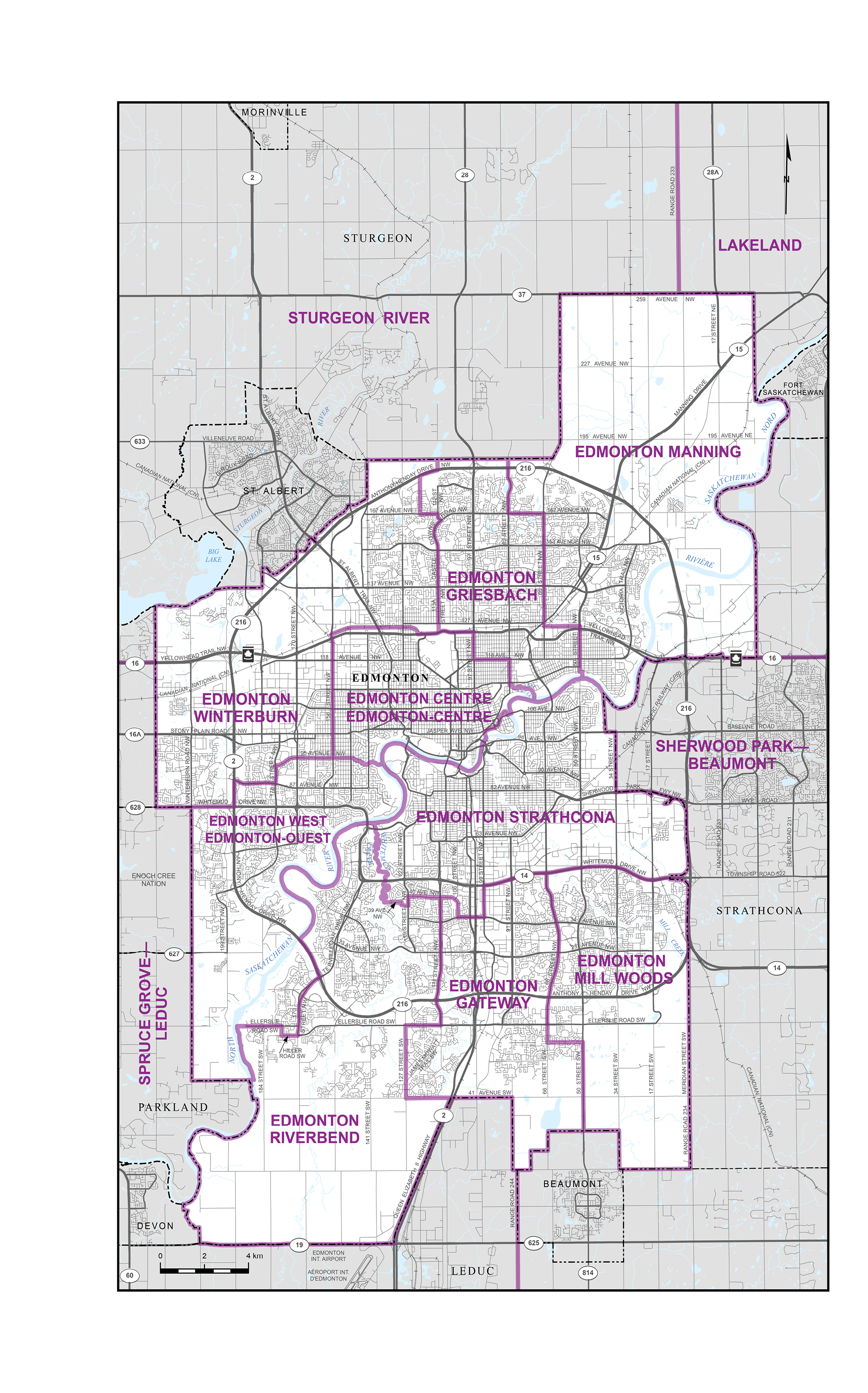
The Commission recommends that, having regard to the community of interest, all nine Edmonton electoral districts be contained within the Edmonton City limits. This has been the approach adopted with respect to Calgary for decades. The average population of the proposed electoral districts in Edmonton is 112,322, or 2.5% under the province’s electoral quota. It therefore follows that Edmonton’s two existing hybrid electoral districts, St. Albert—Edmonton and Edmonton—Wetaskiwin, be substantially reconfigured so that the areas falling outside the Edmonton City limits are removed and added to other electoral districts.
With respect to St. Albert—Edmonton, the Commission proposes to reassign the City of St. Albert to the reconfigured and renamed electoral district of Sturgeon River. This will have the effect of placing St. Albert in the same electoral district as other Francophone communities north of Edmonton, including Legal and Morinville.
The proposed Edmonton Winterburn electoral district is created from the portion of the present St. Albert—Edmonton electoral district that will remain within Edmonton’s City limits. It also includes portions of the existing Edmonton West and Edmonton Griesbach electoral districts.
The hybrid electoral district of Edmonton—Wetaskiwin had a 2021 decennial census population of 209,431, an increase of 89.28% from the 2011 census. This was the highest growth of any electoral district in Canada. The largest portion of this growth was in the Edmonton area, annexed in January 2019. This dramatic population growth necessitated a reconfiguration of Edmonton’s southern electoral districts and allows the City of Wetaskiwin to become part of a reconfigured and renamed electoral district of Wetaskiwin—Lacombe.
The Commission proposes that the Edmonton Mill Woods electoral district be extended south to the City limits. The area west of 66th Street NW in the present Edmonton Mill Woods electoral district will become part of a new electoral district, Edmonton Gateway.
The creation of the proposed electoral district of Edmonton Gateway in the south-centre of the City allows the population growth on the south side of the City to be shared among three electoral districts.
The Commission recommends that the Edmonton Riverbend electoral district be extended south to the City limits, with the eastern portion relocated to the proposed Edmonton Gateway electoral district. A small section in the north has been moved into the electoral district of Edmonton Strathcona.
With the disparity of population between the north and south sides of the North Saskatchewan River, it is proposed that the electoral district of Edmonton West span the river. Most of the Windermere community, located on the east side of the river, has been added. The communities on both sides of the river have newer developments with similar character and interests.
The electoral district of Edmonton Manning’s high population growth required adjustments to bring its numbers into closer alignment with other electoral districts. It is proposed that the most westerly communities be moved into the Edmonton Griesbach electoral district. The communities south of Yellowhead Trail NW, east of 50th Street NW and north of the river are added to the Edmonton Manning electoral district.
The proposed new orientation of the electoral district of Edmonton Griesbach is in a more north-south direction, extending north to the City limits and south to the North Saskatchewan River. This configuration increases the population of the electoral district of Edmonton Griesbach.
Edmonton’s inner-city electoral districts experienced little change in their populations. The Commission proposes that the electoral district of Edmonton Centre be shifted slightly east, gaining some population from Edmonton Griesbach. The southwestern boundary of the electoral district is moved north to 95th Avenue NW.
The Edmonton Strathcona electoral district is altered only slightly, with a few communities to the south of Whitemud Drive NW being added to it. Where possible, the Commission has maintained the North Saskatchewan River as a boundary. The community of Riverdale on the north side of the river has been kept in Edmonton Strathcona as the interests of Riverdale align well with the Cloverdale and Forest Heights communities, which are immediately across the river.
Central Alberta
The electoral district of Sturgeon River—Parkland is located directly north and west of Edmonton. The Commission proposes that the City of St. Albert be placed in this electoral district. This configuration has the benefit of allowing St. Albert and other Francophone communities, such as Legal and Morinville, to maintain their historical and cultural communities of interest. Since only a small portion of the County of Parkland remains in the reconfigured electoral district, it is proposed that the name be changed to Sturgeon River.
Large population growth in communities surrounding Edmonton and Calgary, as well as the corridor between the two cities, has led the Commission to propose the creation of two new electoral districts, Spruce Grove—Leduc and Airdrie—Chestermere, and to recommend significant changes to the adjacent electoral districts.
The new electoral district of Spruce Grove—Leduc includes the growing communities of Spruce Grove, Leduc, Stony Plain and Devon. It is composed of portions of the existing Sturgeon River—Parkland and Edmonton—Wetaskiwin electoral districts.
The new electoral district of Airdrie—Chestermere encompasses the communities of Airdrie and Chestermere, which have experienced particularly rapid population growth over the past decade. Airdrie and Chestermere are located, respectively, to the north and east of Calgary. This new electoral district includes parts of the current Banff—Airdrie and Bow River electoral districts.
The Commission recommends that two reconfigured electoral districts, Wetaskiwin—Lacombe and Red Deer, be created to replace the existing hybrid districts of Red Deer—Lacombe and Red Deer—Mountain View. The proposed Wetaskiwin—Lacombe electoral district, which includes the communities of Wetaskiwin, Lacombe and Sylvan Lake, consists of portions of the current electoral districts of Edmonton—Wetaskiwin, Red Deer—Lacombe and Red Deer—Mountain View. The proposed Red Deer electoral district, which includes the City of Red Deer in its entirety, occupies a portion of the current Red Deer—Mountain View electoral district.
The proposed electoral district of Canmore—Cochrane—Olds responds to the growing populations of Canmore and Cochrane, and includes the communities of Didsbury, Carstairs and Olds. It consists of portions of the current Banff—Airdrie and Red Deer—Mountain View electoral districts as well as small portions of the electoral districts of Foothills and Bow River.
Remaining Electoral Districts
Western Alberta
The Commission proposes that the current electoral district of Yellowhead be extended to include Banff National Park. This places Banff and Jasper National Parks together in a common community of interest. In addition to the inclusion of Banff National Park, the Yellowhead electoral district is expanded to encompass an area west of Range Road 33 and west of Highway 766 taken from the current Red Deer—Lacombe electoral district. The area west of Range Road 50 and a small portion west of Range Road 281 are also added to the Yellowhead electoral district from the current Edmonton—Wetaskiwin electoral district. Finally, an area that was formerly part of the Sturgeon River—Parkland electoral district west of Highway 33 is added to the Yellowhead electoral district.
Southern Alberta
The Commission recommends that the four existing electoral districts in southern Alberta be retained, but with alterations to each.
The Commission proposes that the electoral district of Foothills’ southeastern boundary be moved eastward to include the Blood Indian Reserves No. 148 and No. 148A, which will now be located within the same electoral district as Piikani Nation, Eden Valley Indian Reserve No. 216 and Tsuu T’ina First Nation. The areas to the south and west of the Tsuu T’ina First Nation Indian Reserve and a small portion to the north of the reserve are added to the reconfigured electoral district of Foothills. Last, the Town of Vulcan is included in the electoral district of Foothills. The eastern boundary now runs along Highway 23 and Highway 24.
Due to the population growth of the City of Lethbridge, the Commission recommends that the electoral district of Lethbridge be reduced in geographical size by moving its northern boundary south to the Oldman River. The City of Lethbridge and the outlying communities of Coaldale and Coalhurst will remain within the electoral district.
The Commission proposes that the western boundary of the Medicine Hat—Cardston—Warner electoral district be moved eastward so that the Blood Indian Reserves No. 148 and No. 148A can be located within the Foothills electoral district. The Town of Taber and the Village of Barnwell, currently located in the Bow River electoral district, are proposed to be added to the electoral district of Medicine Hat—Cardston—Warner. The proposed northern boundary of Medicine Hat—Cardston—Warner will move south to Township Road 150.
The boundaries of the Bow River electoral district are proposed to be moved north and east to the Alberta-Saskatchewan border. A number of communities currently in the Bow River electoral district are proposed to be reassigned to other electoral districts. Chestermere, Beiseker and Irricana are proposed to be reassigned to the new Airdrie—Chestermere electoral district, with the Town of Vulcan being moved into the electoral district of Foothills. On the other hand, proposed to be added to the electoral district of Bow River are the following centres: Drumheller, Hanna, Innisfail, Bowden, Oyen, Three Hills, Youngtown, Trochu, Barons, Nobleford and Picture Butte.
Central-Eastern Alberta
The Commission recommends that the three existing electoral districts in central-eastern Alberta be retained, but, in each instance, some changes are made to their boundaries.
The southern boundary of the Battle River—Crowfoot electoral district is proposed to be moved north to follow the southern limits of Paintearth County No. 18 and Special Area No. 4, and to proceed along Highway 589. The proposed northern boundary is, for the most part, defined by the Yellowhead Highway. The municipalities of Lloydminster and Vegreville are to be located within the electoral district of Battle River—Crowfoot. The communities of Camrose, Stettler, Wainwright and Tofield are to remain within its boundaries.
It is proposed that the electoral district of Sherwood Park—Fort Saskatchewan’s southern boundary be moved south and then west, wrapping around Edmonton’s southern City limits to include the City of Beaumont. The proposed northern boundary will mainly follow the Yellowhead Highway. As a result, Fort Saskatchewan will now be located within the proposed boundaries of the Lakeland electoral district. Due to these changes, it is proposed that the name of the Sherwood Park—Fort Saskatchewan electoral district be changed to Sherwood Park—Beaumont.
The Commission proposes that the southern boundary of the Lakeland electoral district be moved north and mainly follow the Yellowhead Highway. Although Lloydminster will no longer be within the electoral district of Lakeland, Fort Saskatchewan will be added. Redwater and Gibbons, which are in the current Sturgeon River—Parkland electoral district, are to be assigned to the newly reconfigured Lakeland electoral district. Adjustments are also made to the northern boundary of the Lakeland electoral district.
Northern Alberta
In 2012, northern Alberta was divided into three electoral districts. The Commission proposes maintaining this configuration, although with some changes.
The City of Grande Prairie has grown substantially. To accommodate this growth, it is proposed that the northern boundary of the Grande Prairie—Mackenzie electoral district end at the northern boundaries of the County of Northern Lights and Paddle Prairie Metis Settlement. As Mackenzie County is no longer included in the reconfigured electoral district, the Commission recommends changing the name of the electoral district to Grande Prairie.
The electoral district of Peace River—Westlock declined slightly in population; thus, it is proposed that Mackenzie County be included. This brings the populations of the proposed electoral districts of Grande Prairie and Peace River—Westlock into closer alignment. As well, small adjustments are proposed to the Peace River—Westlock electoral district’s southern boundary around Lac la Nonne.
The Commission recommends two boundary changes to the electoral district of Fort McMurray—Cold Lake. The first of these is that the area of Athabasca County located north of the La Biche River and the area including the La Biche River Wildland Provincial Park be added to the Fort McMurray—Cold Lake electoral district. The second change adds a small portion of land located south of Highway 28 to the west of Cold Lake Indian Reserve No. 149 and north of Highway 659.
Summary
The electoral district landscape of Alberta has been modified to accommodate three new electoral districts as well as population shifts and changes, as recorded in the 2021 census.
All the existing electoral districts have been changed. Calgary and Edmonton comprise 54.37% of the 2021 census population count for the province of Alberta. Together, they have 20 of Alberta’s 37 electoral districts, which equates to 54.05%.
The Commission proposes one new electoral district for the City of Calgary (Calgary McKnight), and two new electoral districts, one adjacent to the City of Edmonton (Spruce Grove—Leduc), and one adjacent to the City of Calgary (Airdrie—Chestermere). The Commission is satisfied that all the proposed electoral districts can be effectively represented.
Notice of Public Hearings
The Commission will hold public hearings at the places, dates and times listed below.
| Location | Place of hearing | Date of hearing | Time of hearing |
|---|---|---|---|
| Grande Prairie | Delta by Marriott Grande Prairie Airport 11700 99 Avenue |
Tuesday, September 6, 2022 |
1 p.m. |
| Peace River | Quality Hotel & Conference Centre Sawridge 9510 – 100 Street |
Tuesday, September 6, 2022 |
7 p.m. |
| Fort McMurray | Radisson Hotel & Suites Fort McMurray, 435 Gregoire Drive |
Wednesday, September 7, 2022 |
7 p.m. |
| St. Paul | The Landing and Conference Centre 4902 39 Street |
Thursday, September 8, 2022 |
1 p.m. |
| Lloydminster | Holiday Inn & Suites Lloydminster 5612-44th Street, Alberta |
Thursday, September 8, 2022 |
7 p.m. |
| Medicine Hat | Best Western Premier 35 Paul Stober Drive SE |
Friday, September 9, 2022 |
7 p.m. |
| Edmonton | Delta Hotels by Marriott Edmonton South Conference Centre 4404 Gateway Boulevard NW |
Monday, September 12, 2022 |
1 p.m. |
| Edmonton | Delta Hotels by Marriott Edmonton South Conference Centre 4404 Gateway Boulevard NW |
Monday, September 12, 2022 |
7 p.m. |
| Edmonton | Delta Hotels by Marriott Edmonton South Conference Centre 4404 Gateway Boulevard NW |
Tuesday, September 13, 2022 |
1 p.m. |
| St. Albert | St Albert Inn & Suites 156 St. Albert Trail |
Tuesday, September 13, 2022 |
7 p.m. |
| Vegreville | Vegreville Suites 6539 Hwy 16A West |
Wednesday, September 14, 2022 |
1 p.m. |
| Camrose | Ramada Inn 4702 73 Street |
Wednesday, September 14, 2022 |
7 p.m. |
| Wetaskiwin | Best Western Wayside Inn 4103 56 Street |
Thursday, September 15, 2022 |
7 p.m. |
| Calgary | Silver Springs Golf & Country Club 1600 Varsity Estates Drive NW |
Monday, September 19, 2022 |
1 p.m. |
| Calgary | Thorncliffe Greenview Community Association 5600 Centre Street N |
Monday, September 19, 2022 |
7 p.m. |
| Calgary | Haysboro Community Association 1204 89 Avenue SW |
Tuesday, September 20, 2022 |
1 p.m. |
| Airdrie | Town and Country Centre Suite 103, 275 Jensen Drive NE |
Tuesday, September 20, 2022 |
7 p.m. |
| Olds | Pomeroy Inn 4601 46 Avenue |
Wednesday, September 21, 2022 |
1 p.m. |
| Red Deer | Cambridge Hotel and Conference Centre 3310 50 Avenue |
Wednesday, September 21, 2022 |
7 p.m. |
| Drumheller | Badlands Community Facility 80 Veterans Way |
Thursday September 22, 2022 |
1 p.m. |
| Cochrane | Cochrane Lions Club 109 Fifth Avenue |
Thursday, September 22, 2022 |
7 p.m. |
| Banff | Banff Park Lodge Resort Hotel & Conference Centre 201 Lynx Street |
Friday, September 23, 2022 |
1 p.m. |
| Canmore | Canmore Opera House 400 Spring Creek Drive |
Friday, September 23, 2022 |
7 p.m. |
| Lethbridge | Sandman Signature Lethbridge Lodge 320 Scenic Drive S |
Monday, September 26, 2022 |
7 p.m. |
| Virtual hearing | The Commission may choose to hold one or more virtual hearing(s) should it receive sufficient public interest. | Friday, October 14, 2022 |
1 p.m. and 7 p.m. |
Interested persons proposing to make representations must read and follow the rules set out in “Rules for Public Hearings” in the next section of this proposal. There is no entitlement to be heard by the Commission unless, pursuant to the rules, a notice in writing is given, stating the name and address of the person seeking to make the representation to the Commission and indicating concisely the nature of the representation and the interest of such person.
Notices in writing must be received on or before August 15, 2022. They must be mailed or emailed to:
Ms. Ooldouz Sotoudehnia
Commission Secretary
Federal Electoral Boundaries Commission for Alberta
PO Box 45062
Calgary, AB T2G 4X3
or
AB@redecoupage-federal-redistribution.ca
Rules for Public Hearings
The Commission makes the following rules for its proposed public hearings. Rules for making representations are made under the authority of sections 18 and 19 of the Act.
These rules may be cited as “The Rules of the Federal Electoral Boundaries Commission for Alberta, 2022–2023” (hereinafter, “the Rules”).
1. In the Rules:
- a) “advertisement” means the advertisement required by subsection 19(2) of the Act
- b) “Commission” means the Federal Electoral Boundaries Commission for the Province of Alberta, established by proclamation on November 1, 2021
- c) “Commission Secretary” means the person designated as such by the Commission
- d) “notice in writing” means a notice of intention to make a representation, submitted in writing to the Commission Secretary within the time limit established by subsection 19(5) of the Act
- e) “map” means the map published with the advertisement showing the proposed division of the province into electoral districts
- f) “representation” means a representation made in accordance with section 19 of the Act by an interested person as to the division of the province into electoral districts
- g) “sitting” means a sitting held for the hearing of representations in accordance with section 19 of the Act
2. A person giving notice in writing shall name the proposed electoral district or electoral districts that are to be the subject of their representation.
3. For the purpose of interpreting subsection 19(5) of the Act, notice in writing shall be considered to have been given when it is mailed, and the postmark on the envelope containing the notice in writing shall be accepted as proof of the date of its mailing.
4. For the purpose of interpreting subsection 19(5) of the Act, notice in writing shall be considered to have been given where mailed electronically and received by the Commission Secretary within the required time.
5. In accordance with subsection 19(5) of the Act, no representation shall be heard by the Commission at any sittings unless the notice in writing is given to the Commission on or before August 15, 2022, stating the name and address of the person who seeks to make the representation, and indicating concisely the nature of the representation and the interest of the person, unless the Commission decides otherwise in accordance with subsection 19(6) of the Act.
6. A person shall state in their notice in writing at which of the advertised sitting locations such person wishes to appear to make their representation.
7. Where the sender of a notice in writing indicates that their representation may not be made public, the Commission shall not consider the representation contained in the notice in writing.
8. If no notice in writing is received for a sitting, the Commission may cancel the sitting.
9. In the event of a postponement or cancellation of a sitting, the Commission shall give public notice of such postponement or cancellation on local radio stations, and the Commission Secretary shall notify any person who has given notice in writing and has not been heard.
10. If a quorum of commissioners cannot be present at a sitting, the Commission may allow the hearing of representations by one member of the Commission pursuant to section 18 of the Act or may postpone the sitting to a later date.
11. Only one person shall be heard in the presentation of any single representation, including a representation on behalf of an association or group, unless the Commission at its discretion decides otherwise.
12. A person giving notice in writing to make a representation shall indicate the official language in which the representation will be made.
13. A person requiring special assistance to make their oral representation at a sitting shall so indicate in their notice in writing to the Commission Secretary to allow the Commission time to arrange accommodations, as needed.
14. A time limit of 10 minutes per representation will be the general rule.
15. The time limit of 10 minutes includes the setting up and taking down of any audiovisual equipment. Such equipment is the responsibility of the person making the representation.
16. If it appears at a sitting that the Commission cannot complete the hearing of representations within the allotted time, the Commission may adjourn the sitting to a later date at the same or another location, having regard to the convenience of those whose representations have not yet been heard.
17. Sittings will be conducted in compliance with all applicable public health regulations of national, provincial and local authorities.
Virtual Sittings
The Commission may choose to hold one or more virtual sittings should it receive, on or before August 15, 2022, sufficient public interest to make a representation by means of a virtual sitting. The Rules will apply to any and all virtual sittings, as applicable.
Dated at Calgary, Alberta, this 30th day of May, 2022.
The Honourable Justice J.D. Bruce McDonald
Chair
Federal Electoral Boundaries Commission for the Province of Alberta
APPENDIX – Maps, Proposed Boundaries and Names of Electoral Districts
There shall be in the Province of Alberta thirty-seven (37) electoral districts named and described as follows, each of which shall return one member.
In the following descriptions:
- (a) any reference to “road,” “street,” “avenue,” “drive,” “highway,” “trail,” “boulevard,” “river” or “railway” signifies the centre line unless otherwise described;
- (b) quarter sections, sections, townships, ranges and meridians are in accordance with the Dominion Lands system of survey and include the extension thereof in accordance with that system; they are abbreviated as “Qs”, “Sec,” “Tp”, “R” and “W 4” or “W 5”;
- (c) all villages, summer villages, towns, cities, district municipalities, Indian reserves and national parks of Canada lying within the perimeter of the electoral district are included unless otherwise described;
- (d) all First Nation territories lying within the perimeter of the electoral district are included unless otherwise described;
- (e) any reference to “county,” “municipal district,” “special area” and “national park of Canada” for inclusion in an electoral district signifies that all villages, summer villages, towns, cities, Indian reserves and other areas within the county, municipal district, special area and national park of Canada are included unless otherwise described;
- (f) wherever a word or expression is used to denote a territorial division, such word or expression shall indicate the territorial division as it existed or was bounded on the first day of January, 2021, unless otherwise specified;
- (g) the translation of the terms “street,” “avenue” and “boulevard” follows Treasury Board standards, while the translation of all other public thoroughfare designations is based on commonly used terms but has no official recognition; and
- (h) all coordinates are in reference to the North American Datum of 1983 (NAD 83).
The population figure of each electoral district is derived from the 2021 decennial census.
Airdrie—Chestermere
(Population: 113,312)
(Maps 1 and 2)
Consists of:
- (a) the cities of Airdrie and Chestermere;
- (b) the Town of Irricana;
- (c) the Village of Beiseker; and
- (d) that part of the Municipal District of Rocky View County described as follows: commencing at the intersection of the northerly limit of the City of Calgary and Symons Valley Road; thence northerly along said road to a point on the westerly boundary of Sec 36 Tp 27 R 2 W 5 at approximate latitude 51°21′10″N and longitude 114°09′57″W; thence northerly along said westerly boundary and the westerly boundary of Sec 1 and 12 Tp 28 R 2 W 5 to the northerly boundary of Sec 12 Tp 28 R 2 W 5; thence northeasterly in a straight line to Township Road 282; thence easterly along said road to Highway 2a; thence easterly along said highway and along Highway 72 to the northerly limit of the Village of Beiseker; thence generally easterly along said limit to Highway 9; thence generally southwesterly and southerly along said highway to Highway 1 (Trans-Canada Highway); thence easterly along said highway to the easterly limit of said municipal district; thence generally southerly and generally northwesterly along the easterly and southerly limits of said municipal district to the southerly limit of the City of Calgary; thence generally northerly and generally westerly along the easterly and northerly limits of said city to the point of commencement.
Battle River—Crowfoot
(Population: 115,242)
(Map 1)
Consists of:
- (a) the City Camrose;
- (b) that part of the City of Lloydminster lying westerly of the easterly boundary of the Province of Alberta;
- (c) the towns of Bashaw, Castor, Coronation, Daysland, Hardisty, Killam, Provost, Sedgewick, Stettler, Tofield, Vegreville, Viking and Wainwright;
- (d) the villages of Alliance, Amisk, Bawlf, Big Valley, Bittern Lake, Chauvin, Consort, Czar, Donalda, Edberg, Edgerton, Forestburg, Halkirk, Hay Lakes, Heisler, Holden, Hughenden, Irma, Lougheed, Paradise Valley, Rosalind, Ryley and Veteran;
- (e) the summer villages of Rochon Sands and White Sands;
- (f) the municipal districts of Beaver County, Camrose County, Flagstaff County, Paintearth County No. 18, Provost No. 52 and Wainwright No. 61;
- (g) that part of the Municipal District of Lamont County lying southerly of a line described as follows: commencing at the intersection of the easterly limit of Improvement District No. 13 Elk Island and Highway 16 (Yellowhead Highway); thence generally easterly along said highway to Range Road 163; thence northerly along said road to Township Road 532; thence easterly along said road to the westerly limit of Minburn County No. 27;
- (h) that part of the Municipal District of Leduc County lying southerly and easterly of a line described as follows: commencing at the intersection of the southerly limit of Strathcona County and Range Road 221; thence southerly along said road to Township Road 502; thence westerly along said road to an unnamed road; thence southerly and southwesterly along said road to Range Road 223; thence northerly and northwesterly along said road to Township Road 502; thence westerly and southwesterly along said road to Highway 21; thence southeasterly and southerly along said highway to the limit of Camrose County;
- (i) that part of the Municipal District of Minburn County No. 27 lying southerly and westerly of a line described as follows: commencing at the intersection of the easterly limit of Lamont County and Township Road 530; thence easterly along said road to Range Road 155; thence southerly and easterly along said road to Highway 631; thence northerly, northeasterly and easterly along said highway to Range Road 143; thence southerly along said road to Highway 16 (Yellowhead Highway); thence easterly, generally southeasterly and generally easterly along said highway to the limit of Vermilion River County;
- (j) that part of the Municipal District of Stettler County No. 6 lying northerly and easterly of a line described as follows: commencing at the intersection of the easterly limit of Red Deer County and Highway 590; thence easterly along said highway to Range Road 210; thence southerly along said road to Township Road 352; thence easterly and southeasterly along said road to Range Road 205A; thence southerly along said road to Township Road 350; thence easterly along said road to Highway 56; thence easterly along Highway 589 to Highway 855; thence easterly along Township Road 350 to Range Road 151; thence southerly along the westerly boundary of Sec 1 Tp 35 R 15 W 4 to the northerly boundary of Tp 34 R 15 W 4; thence easterly along said boundary to the westerly limit of Special Area No. 2;
- (k) that part of the Municipal District of Vermilion River County lying southerly of a line described as follows: commencing at the intersection of the easterly boundary of the Province of Alberta and Township Road 504; thence westerly along said road, its productions and northwesterly along Township Road 504B to Highway 897; thence generally southerly along said highway to Highway 16 (Yellowhead Highway); thence northwesterly along said highway to the southerly limit for the Village of Kitscoty; thence westerly and northerly along limit of said village to Highway 16 (Yellowhead Highway); thence northwesterly and generally westerly along said highway to the easterly limit of Minburn County No. 27;
- (l) that part of the Specialized Municipality of Strathcona County lying southerly and easterly of a line described as follows: commencing at the intersection of the westerly limit of Beaver County and Township Road 512; thence westerly along said road and along Township Road 512A to Range Road 204; thence southerly along said road to Highway 14; thence westerly along said highway to Range Road 220; thence southerly along said road to the northerly limit of Leduc County; and
- (m) Special Area No. 4.
Bow River
(Population: 115,937)
(Map 1)
Consists of:
- (a) the City of Brooks;
- (b) the towns of Bassano, Bowden, Drumheller, Hanna, Innisfail, Nobleford, Oyen, Picture Butte, Strathmore, Three Hills, Trochu and Vauxhall;
- (c) the villages of Acme, Arrowwood, Barons, Carbon, Carmangay, Champion, Delia, Duchess, Elnora, Empress, Hussar, Linden, Lomond, Milo, Morrin, Munson, Rockyford, Rosemary, Standard and Youngstown;
- (d) the municipal districts of Acadia No. 34, Kneehill County, Newell County, Starland County and Wheatland County;
- (e) that part of the Municipal District of Cypress County lying northerly and westerly of a line described as follows: commencing at the intersection of the easterly boundary for the Province of Alberta and the production of Township Road 150; thence westerly along said production, along said road and its intermittent productions to Highway 41; thence southerly along said highway to Township Road 150; thence westerly along said road to Range Road 43; thence southerly along said road to an underground natural gas pipeline at approximate latitude 50°11′37″N and longitude 110°28′57″W; thence generally southwesterly and northwesterly along said pipeline to an unnamed watercourse at approximate latitude 50°11′53″N and longitude 110°31′20″W; thence generally northwesterly, westerly and southwesterly along said watercourse to the South Saskatchewan River; thence generally northwesterly along said river to approximate latitude 50°13′22″N and longitude 110°36′09″W; thence westerly in a straight line to the most southeasterly point of the Canadian Forces Base Suffield; thence generally westerly along the southerly border of said base to Range Road 61; thence southerly along said road to Township Road 150; thence westerly along said road to Eighth Street; thence southerly along said street to Highway 1 (Trans-Canada Highway); thence northwesterly along said highway to Range Road 93; thence generally southerly along said road to and along Range Road 93A to Township Road 130A; thence northeasterly along said road to an unnamed watercourse at approximate latitude 50°03′44″N and longitude 111°09′50″W; thence generally southeasterly and southerly along said watercourse to the northerly shoreline of the South Saskatchewan River; thence southerly in a straight line to the limit of Forty Mile County No. 8;
- (f) that part of the Municipal District of Lethbridge County lying northerly and easterly of a line described as follows: commencing at the intersection of the southerly limit of Vulcan County and Highway 23; thence generally southerly and southeasterly along said highway to Highway 3; thence easterly along said highway to Range Road 230A; thence northerly along said road to Township Road 100; thence southeasterly and easterly along said road to Range Road 223; thence northerly and northeasterly along said road to Township Road 100; thence southerly, southeasterly and easterly along said road to Range Road 221; thence southerly along said road to Highway 25; thence northeasterly and easterly along said highway to the westerly boundary of Tp 10 R 21 W 4; thence southerly along said boundary to the northerly boundary of Tp 9 R 21 W 4; thence easterly along said boundary to the Oldman River; thence generally northeasterly along said river to the westerly limit of the Municipal District of Taber;
- (g) that part of the Municipal District of Mountain View County lying northerly and easterly of a line described as follows: commencing at the intersection of the southerly limit of Red Deer County and Range Road 43; thence generally southwesterly and southerly along said road to Township Road 340; thence westerly along said road to Range Road 44; thence southerly along said road to Township Road 332; thence generally easterly along said road to Range Road 11; thence southerly along said road to the northerly boundary of Sec 11 Tp 33 R 1 W 5; thence easterly along said boundary to Highway 2; thence southerly along said highway to Highway 27; thence easterly along said highway to the westerly limit of Kneehill County;
- (h) those parts of the Municipal District of Red Deer County:
- (i) consisting of that part of said municipal district lying southerly and westerly of a line described as follows: commencing at the westerly limit of Stettler County No. 6 and Highway 590; thence generally westerly along said highway to Highway 2 and the easterly limit of the Town of Innisfail; thence northeasterly and westerly along said limit to Highway 54; thence northerly and northwesterly along said highway to the Red Deer River; thence generally northerly along said river to Highway 592; thence westerly along said highway and along Township Road 370 to the easterly limit of Clearwater County; and
- (ii) excluding that part of said municipal district lying westerly of a line described as follows: commencing at the westerly limit of said county and Range Road 43; thence northerly along said road to Highway 54; thence easterly along said highway to Range Road 43; thence northerly along said road to the limit of Clearwater County;
- (i) that part of the Municipal District of Rocky View County lying northerly and easterly of a line described as follows: commencing at the intersection of the limit of Kneehill County and Range Road 265; thence southerly along said road to Highway 72; thence easterly along said highway to the northerly limit of the Village of Beiseker; thence generally easterly and southwesterly along said limit to the most southeasterly point of said village; thence southerly, westerly, southerly, generally southwesterly and southerly along Highway 9 to Highway 1 (Trans-Canada Highway); thence easterly along said highway to the westerly limit of Wheatland County;
- (j) that part of the Municipal District of Stettler County No. 6 lying southerly and westerly of a line described as follows: commencing at the intersection of the easterly limit for Red Deer County and Highway 590; thence easterly along said highway to Range Road 210; thence southerly along said road to Township Road 352; thence easterly and southeasterly along said road to Range Road 205A; thence southerly along said road to Township Road 350; thence easterly along said road, along Highway 589 and along Township Road 350 to Range Road 151; thence southerly along the easterly boundary of Sec 2 Tp 35 R 15 W 4 to the northerly boundary of Tp 34 R 15 W 4; thence easterly along said boundary to the westerly limit of Special Area No. 2;
- (k) that part of the Municipal District of Taber lying northerly of a line described as follows: commencing at the intersection of the easterly limit of Lethbridge County and the Oldman River; thence generally easterly along said river to the westerly limit of Cypress County;
- (l) that part of the Municipal District of Vulcan County lying northerly and easterly of a line described as follows: commencing at the intersection of the southerly limit of Wheatland County and the southerly shoreline of the Bow River with Highway 24; thence generally southerly and easterly along said highway to Range Road 250; thence southerly along said road to an unnamed railway; thence northeasterly along said railway to Highway 24; thence easterly, southeasterly and southerly along said highway to Highway 23; thence southerly along said highway to the northerly limit of the Town of Vulcan; thence southerly, easterly, southerly, westerly and generally southwesterly along the limit of said town to Highway 534; thence generally southeasterly and southerly along Highway 23 to the northerly limit of Lethbridge County;
- (m) Special Area No. 2 and Special Area No. 3; and
- (n) the Indian Reserve of Siksika No. 146.
Calgary Centre
(Population: 119,822)
(Map 2)
Consists of that part of the City of Calgary described as follows: commencing at the intersection of Crowchild Trail SW with Glenmore Trail SW (Highway 8); thence northerly along Crowchild Trail SW to 26 Avenue SW; thence westerly along said avenue to 37 Street SW; thence northerly along said street to Bow Trail SW; thence generally easterly along said trail to Crowchild Trail SW; thence northwesterly along said trail to the southerly shoreline of the Bow River; thence generally easterly (passing to the north of Prince’s Island) and generally southerly along said shoreline to Glenmore Trail SE; thence northwesterly and generally westerly along said trail and along Glenmore Trail SW (Highway 8) to the point of commencement.
Calgary Confederation
(Population: 119,070)
(Map 2)
Consists of that part of the City of Calgary described as follows: commencing at the intersection of Sarcee Trail NW with Crowchild Trail NW (Highway 1A); thence southeasterly along Crowchild Trail NW (Highway 1A) to Charleswood Drive NW; thence generally northeasterly along said drive to John Laurie Boulevard NW; thence southeasterly and northeasterly along said boulevard to McKnight Boulevard NW; thence generally easterly along said boulevard and along McKnight Boulevard NE to Deerfoot Trail NE (Highway 2); thence generally southerly along said trail to Memorial Drive NE; thence westerly along said drive to the Canadian Pacific Railway; thence southerly along said railway to the southerly shoreline of the Bow River; thence generally westerly along said shoreline (passing to the north of Prince’s Island) to 16 Avenue NW (Trans-Canada Highway); thence generally westerly along said avenue and along Highway 1 (Trans-Canada Highway) to Stoney Trail NW (Highway 201); thence northerly along said trail to the northerly shoreline of the Bow River; thence generally easterly and southeasterly along said shoreline to the easterly limit of the Community District of Silver Springs; thence northerly along said limit to the point of commencement.
Calgary Crowchild
(Population: 117,541)
(Map 2)
Consists of that part of the City of Calgary lying northerly and westerly of a line described as follows: commencing at the intersection of the northerly limit of said city with Symons Valley Road NW; thence generally southeasterly and southerly along said road to Symons Valley Parkway NW and the northerly limit of the Community District of Evanston; thence westerly along said limit to the easterly limit of the Community District of Kincora; thence northerly, westerly, southerly and westerly along the northerly and easterly limits of said community district to 37 Street NW; thence southerly along said street to Symons Valley Parkway NW; thence westerly along said parkway to Shaganappi Trail NW; thence generally southerly along said trail to Stoney Trail NW (Highway 201); thence westerly along said trail to Sarcee Trail NW; thence generally southerly along said trail to the northerly limit of the Community District of Silver Springs; thence southerly along the easterly limit of said community district to the northerly shoreline of the Bow River; thence generally westerly along said shoreline to the westerly limit of said city.
Calgary Forest Lawn
(Population: 119,626)
(Map 2)
Consists of that part of the City of Calgary described as follows: commencing at the intersection of the easterly limit of said city with 16 Avenue NE (Trans-Canada Highway); thence westerly along said avenue to 36 Street NE; thence northerly along said street to McKnight Boulevard NE; thence generally westerly along said boulevard to Deerfoot Trail NE (Highway 2); thence generally southerly along said trail to Memorial Drive NE; thence westerly along said drive to the Canadian Pacific Railway; thence southerly along said railway to the southerly shoreline of the Bow River; thence generally southerly along said shoreline to Glenmore Trail SE; thence southeasterly along said trail to the easterly shoreline of the Bow River; thence generally southerly along said shoreline to the northerly limit of the Community District of McKenzie Lake; thence easterly along said limit to Douglasdale Point SE; thence northerly along said road to 130 Avenue SE; thence easterly along said avenue to 52 Street SE; thence northerly along said street to Glenmore Trail SE; thence easterly along said trail to the easterly limit of said city; thence northerly, easterly, northerly, westerly and northerly along said limit to the point of commencement.
Calgary Heritage
(Population: 119,361)
(Map 2)
Consists of that part of the City of Calgary described as follows: commencing at the intersection of 37 Street SW and Glenmore Trail SW (Highway 8); thence generally southeasterly, easterly and southeasterly along said trail and along Glenmore Trail SE to the easterly shoreline of the Bow River; thence generally southerly along said shoreline to the production of Fish Creek; thence southwesterly along said production and generally northwesterly along said creek to Bow Bottom Trail SE; thence northerly and northwesterly along said trail to Canyon Meadows Drive SE; thence generally westerly along said drive to Macleod Trail SE; thence southerly along said trail to Fish Creek; thence generally westerly along said creek to the westerly limit of said city; thence generally northerly along said limit and along 37 Street SW to the point of commencement.
Calgary McKnight
(Population: 119,404)
(Map 2)
Consists of that part of the City of Calgary described as follows: commencing at the intersection of the easterly limit of said city with 80 Avenue NE; thence westerly along said avenue and its intermittent productions to a bicycle path at approximate latitude 51°07′31″N and longitude 113°56′07″W; thence northerly in a straight line to the intersection of 96 Avenue NE with 68 Street NE; thence westerly along said avenue to 60 Street NE; thence southerly along said street to 88 Avenue NE; thence westerly along said avenue to Métis Trail NE; thence generally southerly along said trail and along 36 Street NE to 16 Avenue NE (Trans-Canada Highway); thence easterly along said avenue to the easterly limit of said city; thence generally northerly along said limit to the point of commencement.
Calgary Midnapore
(Population: 118,890)
(Map 2)
Consists of that part of the City of Calgary lying southerly and westerly of a line described as follows: commencing at the intersection of the southerly limit of said city and the northerly shoreline of the Bow River; thence generally northwesterly along said shoreline to the production of Fish Creek; thence southwesterly along said production and generally northwesterly along said creek to Bow Bottom Trail SE; thence northerly and northwesterly along said trail to Canyon Meadows Drive SE; thence generally westerly along said drive to Macleod Trail SE; thence southerly along said trail to Fish Creek; thence generally westerly along said creek to the westerly limit of said city.
Calgary Nose Hill
(Population: 118,822)
(Map 2)
Consists of that part of the City of Calgary described as follows: commencing at the intersection of Shaganappi Trail NW and Symons Valley Parkway NW; thence easterly along said parkway to 37 Street NW; thence northerly along said street to the northerly limit of the Community District of Kincora; thence easterly, northerly, easterly and southeasterly along the northerly and easterly limits of said community district to the northerly limit of the Community District of Evanston; thence easterly along said limit to Symons Valley Road NW; thence southeasterly along said road and along Beddington Trail NW to Hidden Creek Drive NW; thence generally northeasterly along said drive to West Nose Creek; thence generally southeasterly along said creek to the northerly limit of the Community District of Panorama Hills; thence easterly and northerly along the northerly and westerly limits of said community district to approximate latitude 51°09′15″N and longitude 114°05′41″W; thence easterly in a straight line to Panorama Hills Boulevard NW; thence generally southeasterly along said boulevard to Country Hills Boulevard NW; thence northeasterly along said boulevard and generally easterly along Country Hills Boulevard NE to Deerfoot Trail NE (Highway 2); thence generally southerly along said trail to McKnight Boulevard NE; thence generally westerly along said boulevard and along McKnight Boulevard NW to John Laurie Boulevard NW; thence southwesterly and northwesterly along said boulevard to Charleswood Drive NW; thence generally southwesterly along said drive to Crowchild Trail NW (Highway 1A); thence northwesterly along said trail to Sarcee Trail NW; thence northeasterly and generally northerly to Stoney Trail NW (Highway 201); thence easterly along said trail to Shaganappi Trail NW; thence generally northerly along said trail to the point of commencement.
Calgary Shepard
(Population: 115,093)
(Map 2)
Consists of that part of the City of Calgary lying southerly and easterly of a line described as follows: commencing at the intersection of the easterly limit of said city with Glenmore Trail SE; thence westerly along said trail to 52 Street SE; thence southerly along said street to 130 Avenue SE; thence westerly along said avenue to Douglasdale Point SE; thence southerly along said road to the northerly limit of the Community District of McKenzie Lake; thence westerly along said limit to the easterly shoreline of the Bow River; thence generally southerly along said shoreline to the southerly limit of said city.
Calgary Signal Hill
(Population: 120,917)
(Map 2)
Consists of that part of the City of Calgary lying southerly and westerly of a line described as follows: commencing at the intersection of the westerly limit of said city with the northerly shoreline of the Bow River at approximate latitude 51°06′04″N and longitude 114°16′51″W; thence generally easterly along said shoreline to Stoney Trail NW (Highway 201); thence southerly along said trail to Highway 1 (Trans-Canada Highway); thence generally easterly along said highway and along 16 Avenue NW (Trans-Canada Highway) to the westerly shoreline of the Bow River; thence generally southeasterly along said shoreline to Crowchild Trail SW; thence southerly along said trail to Bow Trail SW; thence generally westerly along said trail to 37 Street SW; thence southerly along said street to 26 Avenue SW; thence easterly along said avenue to Crowchild Trail SW; thence southerly along said trail to Glenmore Trail SW (Highway 8); thence westerly and generally northwesterly along said trail to 37 Street SW; thence southerly along said street to the westerly limit of said city.
Calgary Skyview
(Population: 118,238)
(Map 2)
Consists of that part of the City of Calgary lying northerly and easterly of a line described as follows: commencing at the intersection of the northerly limit of said city with Symons Valley Road NW; thence generally southeasterly along said road and along Beddington Trail NW to Hidden Creek Drive NW; thence generally northeasterly along said drive to West Nose Creek; thence generally southeasterly along said creek to the northerly limit of the Community District of Panorama Hills; thence easterly and northerly along the northerly and westerly limits of said community district to approximate latitude 51°09′15″N and longitude 114°05′41″W; thence easterly in a straight line to Panorama Hills Boulevard NW; thence generally southeasterly along said boulevard to Country Hills Boulevard NW; thence northeasterly along said boulevard and generally easterly along Country Hills Boulevard NE to Deerfoot Trail NE (Highway 2); thence generally southerly along said trail to McKnight Boulevard NE; thence generally easterly along said boulevard to Métis Trail NE; thence generally northerly along said trail to 88 Avenue NE; thence easterly along said avenue to 60 Street NE; thence northerly along said street to 96 Avenue NE; thence easterly along said avenue to 68 Street NE; thence south in a straight line to 80 Avenue NE; thence easterly along said avenue and its intermittent productions to the easterly limit of said city.
Canmore—Cochrane—Olds
(Population: 110,350)
(Maps 1 and 2)
Consists of:
- (a) the towns of Canmore, Carstairs, Cochrane, Crossfield, Didsbury, Olds and Sundre;
- (b) the Village of Cremona;
- (c) the summer villages of Ghost Lake and Waiparous;
- (d) the Municipal District of Bighorn No. 8;
- (e) that part of the Municipal District of Mountain View County lying southerly and westerly of a line described as follows: commencing at the intersection of the westerly limit of Red Deer County and Range Road 43; thence southwesterly, southerly, westerly and southerly along said road to Township Road 340; thence westerly along said road to Range Road 44; thence southerly along said road to Township Road 332; thence generally easterly along said road to Range Road 11; thence southerly along said road to the northerly boundary of Sec 11 Tp 33 R 1 W 5; thence easterly along said boundary to Highway 2; thence southerly along said highway to Highway 27; thence easterly along said highway to the westerly limit of Kneehill County;
- (f) those parts of the Municipal District of Rocky View County described as follows:
- (i) that part lying northerly and westerly of a line described as follows: commencing at the intersection of the southerly limit of Kneehill County and Range Road 265; thence southerly along said road to Highway 72 (Township Road 282); thence westerly along said highway to Highway 2; thence westerly along Highway 2A (common with Township Road 282) and then along Township Road 282 to Range Road 21; thence southwesterly in a straight line to approximate latitude 51°23′14″N and longitude 114°09′57″W; thence south in a straight line to Symons Valley Road (Road 772); thence southerly along said road to the northerly limit for the City of Calgary; and
- (ii) excluding the area lying southerly of the northerly boundary of Tp 23;
- (g) those parts of the Improvement District Kananaskis described as follows:
- (i) that part lying northerly of a line described as follows: commencing at the intersection of the easterly limit of Improvement District No. 9 Banff and the northerly boundary of Tp 23; thence easterly along said boundary to the westerly limit of the Town of Canmore;
- (ii) that part lying northerly and westerly of a line described as follows: commencing at the intersection of the easterly limit of the Town of Canmore and the northerly boundary of Tp 23; thence easterly along said boundary to the westerly boundary of Tp 24 R 7; thence northerly along said boundary to approximate latitude 51°03′33″N and longitude 114°58′42″W; thence northeasterly in a straight line to the southerly boundary for the Indian reserves of Stoney nos. 142, 143, 144; and
- (h) the Indian reserves of Stoney nos. 142, 143, 144 and Stoney No. 142B.
Edmonton Centre
(Population: 111,183)
(Map 3)
Consists of that part of the City of Edmonton described as follows: commencing at the intersection of Yellowhead Trail NW (Yellowhead Highway) with 97 Street NW; thence southerly along said street to 118 Avenue NW; thence easterly along said avenue to 82 Street NW; thence southerly along said street to Rat Creek; thence generally easterly and southerly along said creek and along its southerly production to the southerly shoreline of the North Saskatchewan River; thence westerly and southwesterly along said shoreline to Rowland Road NW; thence westerly along said road to 87 Street NW; thence northerly and northwesterly along said street to 103A Avenue NW; thence southwesterly along said avenue to 89 Street NW; thence southwesterly in a straight line to the northerly production of 92 Street NW at approximate latitude 53°32′50″N and longitude 113°28′28″W; thence southerly along said production to Rowland Road NW; thence southwesterly and westerly along said road to 95 Street NW; thence southerly along said street to 101 Avenue NW; thence westerly along said avenue to 95A Street NW; thence westerly and southwesterly along Grierson Hill NW to approximate latitude 53°32′29″N and longitude 113°29′06″W; thence southerly in a straight line to the southerly shoreline of the North Saskatchewan River at approximate latitude 53°32′20″N and longitude 113°29′01″W; thence generally westerly along said shoreline to the production of an unnamed watercourse at approximate latitude 53°31′44″N and longitude 113°33′30″W in the MacKenzie Ravine; thence generally northwesterly along said watercourse to approximate latitude 53°31′52″N and longitude 113°34′32″W; thence northwesterly in a straight line to the intersection of 95 Avenue NW and 148 Street NW; thence westerly along 95 Avenue NW to 156 Street NW; thence northerly along said street to the Canadian National Railway; thence northeasterly, easterly, southeasterly and southerly along said railway to Yellowhead Trail NW (Yellowhead Highway); thence generally easterly along said highway to the point of commencement.
Edmonton Gateway
(Population: 110,524)
(Map 3)
Consists of that part of the City of Edmonton described as follows: commencing at the intersection of the southerly limit of said city with 41 Avenue SW; thence westerly along said avenue to James Mowatt Trail SW; thence northerly along said trail to 35 Avenue SW; thence northerly along the southerly production of 127 Street SW and continuing along said street to Ellerslie Road SW; thence easterly along said road to 111 Street SW; thence generally northerly along said street and along 111 Street NW to 40 Avenue NW; thence easterly and southeasterly along said avenue to 106 Street NW; thence southeasterly and southerly along said street to 34 Avenue NW; thence easterly along said avenue to 99 Street NW; thence northerly along said street to Whitemud Drive NW (Highway 14); thence easterly along said drive to 66 Street NW; thence generally southerly along said street to Anthony Henday Drive NW (Highway 216); thence southerly along 66 Street SW to the northerly boundary of Qs SW Sec 23 Tp 51 R 24 W 4; thence easterly along said boundary and along the northerly boundary of Qs SE Sec 23 Tp 51 R 24 W 4 to its production with 50 Street SW (Highway 814); thence southerly along said street to the southerly limit of said city; thence generally southwesterly along the southerly and easterly limits of said city to Range Road 243; thence northerly and westerly along the westerly and southerly limits of said city to the point of commencement.
Edmonton Griesbach
(Population: 113,913)
(Map 3)
Consists of that part of the City of Edmonton described as follows: commencing at the intersection of the northerly limit of said city with 82 Street NW; thence generally southerly along said street to 167 Avenue NW; thence easterly along said avenue to 66 Street NW; thence southerly along said street to the Canadian National Railway; thence easterly along said railway to 50 Street NW; thence southerly along said street to Ada Boulevard NW; thence easterly along said boulevard to the limit of the Neighbourhood of Beverly Heights; thence southerly along the limit of said neighbourhood to the southerly boundary of said neighbourhood limit; thence easterly along the limit of said neighbourhood to the approximate latitude 53°33′55″N and longitude 113°25′00″W; thence southerly in a straight line to the southerly shoreline of the North Saskatchewan River; thence generally southwesterly along said shoreline to approximate latitude 53°33′13″N and longitude 113°27′02″W; thence northerly in a straight line to the production of Rat Creek; thence generally northwesterly along said creek to 82 Street NW; thence northerly along said street to 118 Avenue NW; thence westerly along said avenue to 97 Street NW; thence northerly along said street to Yellowhead Trail NW (Highway 16); thence generally westerly along said highway to the southerly production of 113A Street NW; thence northerly along said production to 113A Street NW; thence northerly along said street to 137 Avenue NW; thence generally northerly along Castle Downs Road NW to 112 Street NW; thence northwesterly and northerly along said street to 167 Avenue NW; thence westerly along said avenue to the westerly limit of the Neighbourhood of Canossa; thence northerly along said limit of Canossa and its production to Anthony Henday Drive (Highway 216); thence easterly along said drive to the northerly production of 112 Street NW; thence northerly along said production to the northerly limit of said city; thence westerly along said limit to the point of commencement.
Edmonton Manning
(Population: 111,039)
(Map 3)
Consists of that part of the City of Edmonton lying northerly and easterly of a line described as follows: commencing at the intersection of the northerly limit of said city with 82 Street NW; thence generally southerly along said street to 167 Avenue NW; thence easterly along said avenue to 66 Street NW; thence southerly along said street to the Canadian National Railway; thence easterly along said railway to 50 Street NW; thence southerly along said street to Ada Boulevard NW; thence easterly along said boulevard to the limit of the Neighbourhood of Beverly Heights; thence southerly along said limit to its southerly boundary; thence easterly along said limit to the approximate latitude 53°33′55″N and longitude 113°25′00″W; thence southerly in a straight line to the southerly shoreline of the North Saskatchewan River; thence easterly and southeasterly along said shoreline to the easterly limit of said city.
Edmonton Mill Woods
(Population: 113,208)
(Map 3)
Consists of that part of the City of Edmonton lying southerly and easterly of a line described as follows: commencing at the intersection of the easterly limit of said city with Whitemud Drive NW (Highway 14); thence generally westerly along said drive to 66 Street NW; thence generally southerly along said street to Anthony Henday Drive NW (Highway 216); thence southerly along 66 Street SW to the northerly boundary of Qs SW Sec 23 Tp 51 R 24 W 4; thence easterly along said boundary and along the northerly boundary of Qs SE Sec 23 Tp 51 R 24 W 4 to the intersection of its production with 50 Street SW; thence southerly along said street to the southerly limit of said city.
Edmonton Riverbend
(Population: 113,181)
(Map 3)
Consists of that part of the City of Edmonton described as follows: commencing at the intersection of the southerly limit of said city with the westerly shoreline of the North Saskatchewan River; thence easterly in a straight line to the easterly shoreline of said river; thence generally northerly along said shoreline to the westerly production of Ellerslie Road SW; thence easterly along said production and along said road to 178 Street SW; thence southerly along said street and its production to Hiller Road SW; thence easterly along said road to 170 Street SW; thence generally northerly to Windermere Boulevard NW; thence northeasterly along Terwillegar Drive NW to Anthony Henday Drive NW (Highway 216); thence northwesterly along said drive to the easterly shoreline of the North Saskatchewan River; thence generally northeasterly along said shoreline to Whitemud Creek; thence generally southerly along said creek to the westerly production of 39 Avenue NW; thence easterly along said production and said 39 Avenue NW to 121 Street NW; thence southerly along said street to Fairway Drive NW; thence easterly along said drive to 119 Street NW; thence northerly along said street to 40 Avenue NW; thence easterly along said avenue to 111 Street NW; thence generally southerly along said street to Anthony Henday Drive NW (Highway 216); thence southerly along 111 Street SW to Ellerslie Road SW; thence westerly along said road to 127 Street SW; thence southerly along said street and its production to 41 Avenue SW; thence easterly along said avenue to the southerly limit of said city and Highway 2; thence southerly along said highway to Highway 19; thence westerly along said highway to the westerly limit of said city; thence generally northerly along said limit to the point of commencement.
Edmonton Strathcona
(Population: 111,580)
(Map 3)
Consists of that part of the City of Edmonton described as follows: commencing at the intersection of the easterly limit of said city with the southerly shoreline of the North Saskatchewan River; thence generally westerly along said shoreline to Rowland Road NW; thence westerly along said road to 87 Street NW; thence northerly and northwesterly along said street to 103A Avenue NW; thence southwesterly along said avenue to 89 Street NW; thence southwesterly in a straight line to the northerly production of 92 Street NW at approximate latitude 53°32′50″N and longitude 113°28′28″W; thence southerly along said production to Rowland Road NW; thence southwesterly and westerly along said road to 95 Street NW; thence southerly along said street to 101 Avenue NW; thence westerly along said avenue to 95A Street NW; thence westerly and southwesterly along Grierson Hill NW to approximate latitude 53°32′29″N and longitude 113°29′06″W; thence southerly in a straight line to the southerly shoreline of the North Saskatchewan River at approximate latitude 53°32′20″N and longitude 113°29′01″W; thence generally southwesterly along said shoreline to Whitemud Creek; thence generally southerly along said creek to the westerly production of 39 Avenue NW; thence easterly along said production and along 39 Avenue NW to 121 Street NW; thence southerly along said street to Fairway Drive NW; thence easterly along said drive to 119 Street NW; thence northerly along said street to 40 Avenue NW; thence easterly and southeasterly along said avenue to 106 Street NW; thence southeasterly and southerly along said street to 34 Avenue NW; thence easterly along said avenue to 99 Street NW; thence northerly along said street to Whitemud Drive NW (Highway 14); thence generally easterly along said drive to the easterly limit of said city; thence generally northerly, generally westerly and generally northerly along said limit to the point of commencement.
Edmonton West
(Population: 112,948)
(Map 3)
Consists of that part of the City of Edmonton described as follows: commencing at the intersection of the westerly limit of said city with Whitemud Drive NW; thence easterly along said drive to Anthony Henday Drive NW (Highway 216); thence northerly along said drive to 87 Avenue NW; thence generally easterly along said avenue to 178 Street NW; thence northerly along said street to 95 Avenue NW; thence northeasterly and easterly along said avenue to 148 Street NW; thence southeasterly in a straight line to the production of an unnamed watercourse in the MacKenzie Ravine; thence generally southeasterly along said watercourse and its production to the easterly shoreline of the North Saskatchewan River; thence generally southwesterly along said shoreline to Anthony Henday Drive NW (Highway 216); thence southeasterly along said drive to Terwillegar Drive NW; thence southwesterly along said drive to Windermere Boulevard NW; thence generally southerly along 170 Street SW to Hiller Road SW; thence westerly along the said road to the southerly production of 178 Street SW; thence northerly along said production and along said street to Ellerslie Road SW; thence westerly along said road and along its westerly production to the easterly shoreline of the North Saskatchewan River; thence generally southeasterly along said shoreline to approximate latitude 53°24′12″N and longitude 113°38′46″W; thence westerly in a straight line to the westerly limit of said city; thence westerly and northerly along said limit to the point of commencement.
Edmonton Winterburn
(Population: 113,323)
(Map 3)
Consists of that part of the City of Edmonton lying northerly and westerly of a line described as follows: commencing at the intersection of the westerly limit of said city with Whitemud Drive NW; thence easterly along said drive to Anthony Henday Drive NW (Highway 216); thence northerly along said drive to 87 Avenue NW; thence generally easterly along said avenue to 178 Street NW; thence northerly along said street to 95 Avenue NW; thence northeasterly and easterly along said avenue to 156 Street NW; thence northerly along said street to the Canadian National Railway; thence easterly and southeasterly along said railway to Yellowhead Trail NW (Yellowhead Highway); thence easterly along said highway to the southerly production of 113A Street NW; thence northerly along said production and said street to 137 Avenue NW; thence generally northerly along Castle Downs Road NW to 112 Street NW; thence northwesterly and northerly along said street to 167 Avenue NW; thence westerly along said avenue to the westerly limit of the Neighbourhood of Canossa; thence northerly along the westerly limit of said neighbourhood and its production to Anthony Henday Drive (Highway 216); thence easterly along said drive to the northerly production of 112 Street NW; thence northerly along said production to the northerly limit of said city.
Foothills
(Population: 115,857)
(Maps 1 and 2)
Consists of:
- (a) the towns of Black Diamond, Claresholm, Fort Macleod, High River, Nanton, Okotoks, Pincher Creek, Stavely, Turner Valley and Vulcan;
- (b) the villages of Cowley, Glenwood, Hill Spring and Longview;
- (c) the municipal districts of Foothills County, Pincher Creek No. 9, Ranchland No. 66 and Willow Creek No. 26;
- (d) the Municipal District of Cardston County, excluding the area lying southerly and easterly of a line described as follows: commencing at the intersection of the Belly River and the southerly limit of said municipal district; thence generally northerly along said river to the southerly boundary the Blood Indian Reserve No. 148; thence generally easterly and generally northeasterly along the southerly and easterly boundaries of said Indian reserve to the westerly limit of Lethbridge County at approximate latitude 49°33′57″N and longitude 112°49′58″W;
- (e) that part of the Municipal District of Lethbridge County lying southerly and westerly of a line described as follows: commencing at the intersection of the northerly limit of said municipal district and Highway 23; thence generally southerly along said highway to Highway 3; thence easterly and southeasterly along said highway to Highway 509; thence westerly and southwesterly along said highway to the Oldman River and the westerly limit of said municipal district;
- (f) that part of the Municipal District of Rocky View County lying southerly of the northerly boundary of Tp 23;
- (g) that part of the Municipal District of Vulcan County lying southerly and westerly of a line described as follows: commencing at the intersection of the southerly limit for said municipal district and Highway 23; thence generally northerly along said highway to the easterly limit of the Town of Vulcan; thence northwesterly, northerly, easterly, northerly and westerly along the easterly limit of said town to Highway 23; thence generally northerly along said highway to Highway 24; thence generally northerly and easterly to an unnamed railway; thence southwesterly along said railway to Range Road 250; thence northerly along said road to Highway 24; thence easterly and generally northerly along said highway to the northerly limit of said municipal district;
- (h) the Specialized Municipality of Crowsnest Pass;
- (i) that part of the Kananaskis Improvement District lying southerly and easterly of a line described as follows: commencing at the intersection of the westerly limit of said improvement district and the north boundary of Tp 23; thence east along the northerly boundary of Tp 23 to the southerly limit of the Town of Canmore; thence generally easterly along said limit to the northerly boundary of Tp 23; thence east along said boundary to the west boundary of Tp 24 R 7 W 5; thence north along said boundary to approximate latitude 51°03′33″N and longitude 114°58′42″W; thence northeasterly in a straight line to the northerly limit of said improvement district;
- (j) that part of Improvement District No. 4 Waterton lying westerly of a line described as follows: commencing at the intersection of the southerly boundary of the Province of Alberta and the Belly River; thence generally northerly along said river to the southerly boundary of the Blood Indian Reserve No. 148A; and
- (k) the Indian reserves of Blood No. 148, Blood No. 148A, Eden Valley No. 216, Peigan Timber Limit “B”, Piikani and Tsuu T’ina Nation No. 145.
Fort McMurray—Cold Lake
(Population: 110,779)
(Map 1)
Consists of:
- (a) the City of Cold Lake;
- (b) that part of the Municipal District of Athabasca County lying easterly and northerly of a line described as follows: commencing at a point along the northerly shoreline of the Athabasca River at approximate latitude 54°58′14″N and longitude 112°46′39″W; thence south in a straight line to the limit of La Biche River Wildland Provincial Park; thence generally southerly and easterly along the limit of said provincial park to a point along the La Biche River at approximate latitude 54°56′39″N and longitude 112°30′52″W; thence generally easterly along said river to the limit of Athabasca County;
- (c) that part of the Municipal District of Bonnyville No. 87 lying northerly and easterly of a line described as follows: commencing at the intersection of the easterly boundary of the Province of Alberta with the northerly limit of the Elizabeth Metis Settlement; thence westerly along the limit of said Metis settlement to Range Road 420; thence westerly and northwesterly along Township Road 610 to Highway 897; thence southwesterly and westerly along said highway to the southeasterly corner of Cold Lake Indian Reserve No. 149; thence westerly and generally northerly along the southerly and westerly boundaries of said Indian reserve to Highway 659 at approximate latitude 54°15′49″N and longitude 110°22′50″W; thence northwesterly and westerly along said highway to Range Road 452; thence northerly along said road to Township Road 614; thence generally westerly along said road, along Highway 660 and along Township Road 612 to the westerly limit of the Municipal District of Bonnyville No. 87;
- (d) the Municipal District of Opportunity No. 17, excepting the area described as follows: commencing at the intersection of the easterly limit of Northern Sunrise County and a point at approximate latitude 56°48′28″N and longitude 114°57′31″W; thence easterly in a straight line to a point at approximate latitude 56°48′16″N and longitude 114°04′44″W; thence southerly in a straight line to a point at approximate latitude 56°27′24″N and longitude 114°04′54″W; thence westerly in a straight line to a point on the easterly limit of Northern Sunrise County at approximate latitude 56°27′33″N and longitude 114°56′59″W; thence northerly, generally westerly, northerly, easterly and northerly along said easterly limit to the point of commencement;
- (e) the Municipal District of Lac la Biche County and the Regional Municipality of Wood Buffalo;
- (f) Improvement District No. 349;
- (g) Improvement District No. 24 Wood Buffalo, excepting the area described as follows: commencing at a point on the westerly limit of said improvement district at approximate latitude 58°45′55″N and longitude 114°00′00″W; thence east in a straight line to the westerly limit of Tp 112 R 22; thence southerly along said limit to the northerly limit of Tp 111; thence westerly along said northerly limit to a point on the westerly shoreline of the Peace River at approximate latitude 58°41′21″N and longitude 113°55′29″W; thence southwesterly along said shoreline to the easterly limit of Mackenzie County; thence northerly along said easterly limit to the point of commencement;
- (h) the Settlement of Desmarais; and
- (i) the Indian reserves of Allison Bay No. 219, Beaver Lake No. 131, Cold Lake No. 149, Cold Lake No. 149A, Cold Lake No. 149B, Dog Head No. 218, Fort McKay No. 174, Gregoire Lake No. 176, Gregoire Lake No. 176A, Heart Lake No. 167, Janvier No. 194, Jean Baptiste Gambler No. 183, Old Fort No. 217, Thabacha Náre No. 196A, Thebathi No. 196, Wabasca No. 166, Wabasca No. 166A, Wabasca No. 166B, Wabasca No. 166C and Wabasca No. 166D.
Grande Prairie
(Population: 112,902)
(Map 1)
Consists of:
- (a) the City of Grande Prairie;
- (b) the towns of Beaverlodge, Manning, Sexsmith, Spirit River and Wembley;
- (c) the villages of Hines Creek, Hythe and Rycroft;
- (d) the municipal districts of Clear Hills, Grande Prairie County No. 1, Northern Lights County, Saddle Hills County and Spirit River No. 133;
- (e) that part of the Municipal District of Greenview No. 16 lying northerly and westerly of a line described as follows: commencing at a point on the westerly boundary of the Province of Alberta at approximate latitude 54°35′15″N and longitude 120°00′00″W; thence easterly in a straight line to approximate latitude 54°35′20″N and longitude 117°30′34″W; thence northerly in a straight line to the southeasterly boundary of Sturgeon Lake Indian Reserve No. 154; thence northerly, easterly and northerly along the easterly boundary of said Indian reserve to a point on the westerly production of Township Road 704 at approximate latitude 55°05′00″N and longitude 117°21′43″W; thence easterly along said production to Range Road 230; thence generally northerly along said road, Range Road 225 and its intermittent productions to the northerly limit of the Municipal District of Greenview No. 16; and
- (f) the Indian reserves of Clear Hills No. 152C, Horse Lakes No. 152B, Sturgeon Lake No. 154 and Sturgeon Lake No. 154A.
Lakeland
(Population: 115,854)
(Maps 1 and 3)
Consists of:
- (a) the City of Fort Saskatchewan;
- (b) the towns of Athabasca, Bonnyville, Bruderheim, Elk Point, Gibbons, Lamont, Mundare, Redwater, Smoky Lake, St. Paul, Two Hills and Vermilion;
- (c) the villages of Andrew, Boyle, Chipman, Glendon, Innisfree, Kitscoty, Mannville, Marwayne, Myrnam, Vilna and Waskatenau;
- (d) the summer villages of Bondiss, Bonnyville Beach, Horseshoe Bay, Island Lake, Island Lake South, Mewatha Beach, Pelican Narrows, South Baptiste, Sunset Beach, West Baptiste and Whispering Hills;
- (e) the municipal districts of Smoky Lake County, St. Paul County No. 19, Thorhild County and Two Hills County No. 21;
- (f) that part of the Municipal District of Athabasca County lying southerly and westerly of a line described as follows: commencing at a point along the northerly shoreline of the Athabasca River at approximate latitude 54°58′14″N and longitude 112°46′39″W; thence southerly in a straight line to the limit of La Biche River Wildland Provincial Park; thence generally southerly and westerly along limit of said provincial park to a point along the La Biche River at approximate latitude 54°56′39″N and longitude 112°30′52″W; thence generally easterly along said river to the limit of Athabasca County;
- (g) that part of the Municipal District of Bonnyville No. 87 lying southerly and westerly of a line described as follows: commencing at the intersection of the easterly boundary of the Province of Alberta with the northerly limit of the Elizabeth Metis Settlement; thence westerly along said limit to Range Road 420; thence westerly and northwesterly along Township Road 610 to Highway 897; thence southwesterly and westerly along said highway to the easterly boundary of the Cold Lake Indian Reserve No. 149; thence westerly and northerly along the southerly and westerly boundaries of said Indian reserve to Highway 659 at approximate latitude 54°15′49″N and longitude 110°22′50″W; thence northwesterly and westerly along said highway to Range Road 452; thence northerly along said road to Township Road 614; thence generally westerly along said road, along Highway 660 and along Township Road 612 to the westerly limit of the Municipal District of Bonnyville No. 87;
- (h) that part of the Municipal District of Lamont County lying northerly of a line described as follows: commencing at the intersection of the easterly limit of Improvement District No. 13 Elk Island and Highway 16 (Yellowhead Highway); thence generally easterly along said highway to Range Road 163; thence northerly along said road to Township Road 532; thence easterly along said road to the limit of Minburn County No. 27;
- (i) that part of the Municipal District of Minburn County No. 27 lying northerly and easterly of a line described as follows: commencing at the intersection of the westerly limit for Lamont County and Township Road 530; thence easterly along said road to Range Road 155; thence southerly and easterly to Highway 631; thence northerly, northeasterly and easterly along said highway to Range Road 143; thence southerly along said road to Highway 16 (Yellowhead Highway); thence easterly, generally southeasterly and easterly to the limit of Vermilion River County;
- (j) that part of the Municipal District of Sturgeon County lying southerly and easterly of a line described as follows: commencing at the intersection of the southerly limit of Thorhild County and Range Road 230; thence southerly along said road to Highway 28; thence southwesterly and southerly along said highway to Highway 28a; thence southerly along said highway to the northerly limit for the Town of Gibbons; thence westerly, generally southwesterly and southerly along limit of said town to Township Road 560; thence southerly along Range Road 233 to the northerly limit for the City of Edmonton;
- (k) that part of the Municipal District of Vermilion River County lying northerly of a line described as follows: commencing at the intersection of the easterly boundary of the Province of Alberta and Township Road 504; thence westerly along said road, its productions and along Township Road 504B to Highway 897; thence generally southerly along said highway to Highway 16 (Yellowhead Highway); thence northwesterly along said highway to a point along the limit of the Village of Kitscoty at approximate latitude 53°20′11″N and longitude 110°19′59″W; thence westerly and northerly along said limit to Highway 16 (Yellowhead Highway); thence northwesterly and generally westerly along said highway to the easterly limit of Minburn County No. 27;
- (l) that part of the Specialized Municipality of Strathcona County lying northerly and easterly of a line described as follows: commencing at the intersection of the easterly limit of the City of Edmonton and Highway 16 (Yellowhead Highway); thence easterly along said highway to Range Road 215; thence southerly along said road to Wye Road; thence easterly and southeasterly along said road to Range Road 210; thence northerly along said road to the limit of Beaver County;
- (m) Improvement District No. 13 Elk Island;
- (n) the Indian reserves of Kehewin No. 123, Puskiakiwenin No. 122, Unipouheos No. 121 and White Fish Lake No. 128; and
- (o) that part of the Makaoo Indian Reserve No. 120 lying westerly of the easterly boundary of the Province of Alberta.
Lethbridge
(Population: 115,008)
(Map 1)
Consists of:
- (a) the City of Lethbridge;
- (b) the towns of Coaldale and Coalhurst; and
- (c) that part of the Municipal District of Lethbridge County lying southerly and easterly of a line described as follows: commencing at the intersection of the Blood Indian Reserve No. 148 boundary and Highway 509; thence northeasterly and easterly along said highway to Highway 3; thence northwesterly along said highway to Range Road 230A; thence northeasterly along said road to Township Road 100; thence southeasterly and generally easterly along said road to Range Road 221; thence southerly along said road to Highway 25; thence northeasterly and easterly along said highway to the westerly boundary of Tp 10 R 21 W 4; thence southerly along said boundary to the northerly boundary of Tp 9 R 21 W4; thence easterly along said limit to the Oldman River; thence generally northeasterly along said river to the westerly limit for the Municipal District of Taber.
Medicine Hat—Cardston—Warner
(Population: 117,447)
(Map 1)
Consists of:
- (a) the City of Medicine Hat;
- (b) the towns of Bow Island, Cardston, Magrath, Milk River, Raymond, Redcliff and Taber;
- (c) the villages of Barnwell, Coutts, Foremost, Stirling and Warner;
- (d) the municipal districts of Forty Mile County No. 8 and Warner County No. 5;
- (e) that part of the Municipal District of Cardston County lying southerly and easterly of a line described as follows: commencing at the intersection of the Belly River and the southerly limit of said municipal district; thence generally northerly along said river to the southerly boundary of the Blood Indian Reserve No. 148; thence generally easterly and generally northeasterly along the southerly and easterly boundaries of said Indian reserve to the westerly limit of Lethbridge County at approximate latitude 49°33′57″N and longitude 112°49′58″W;
- (f) that part of the Municipal District of Cypress County lying southerly and easterly of a line described as follows: commencing at the intersection of the easterly boundary of the Province of Alberta with the production of Township Road 150; thence westerly along said production, Township Road 150 and along its intermittent productions to Highway 41; thence southerly along said highway to Township Road 150; thence westerly along said road to Range Road 43; thence southerly along said road to an underground natural gas pipeline at approximate latitude 50°11′37″N and longitude 110°28′57″W; thence southwesterly and northwesterly along said pipeline to an unnamed watercourse at approximate latitude 50°11′53″N and longitude 110°31′20″W; thence generally northwesterly, westerly and southwesterly along said watercourse to the South Saskatchewan River; thence generally northwesterly along said river to the southeasternmost point of the Canadian Forces Base Suffield; thence westerly along the southerly boundary of said base to Range Road 61; thence southerly along said road to Township Road 150; thence westerly along said road to Eighth Street; thence southerly along said street to Highway 1 (Trans-Canada Highway); thence northwesterly along said highway to Range Road 93; thence generally southerly along said road to and along Range Road 93A to Township Road 130A; thence northeasterly along said road to an unnamed watercourse at approximate latitude 50°03′44″N and longitude 111°09′50″W; thence generally southeasterly along said watercourse to the northerly shoreline of the South Saskatchewan River; thence southerly in a straight line to the northerly limit of Forty Mile County No. 8;
- (g) that part of the Municipal District of Taber lying southerly of a line described as follows: commencing at the intersection of the easterly limit of said municipal district and the mouth of the Oldman River at the South Saskatchewan River; thence generally westerly along Oldman River to a point at approximate latitude 49°51′55″N and longitude 112°26′35″W; thence southerly in a straight line to the westerly limit of said municipal district; and
- (h) that part of Improvement District No. 4 Waterton lying easterly of a line described as follows: commencing at the intersection of the southerly boundary of the Province of Alberta and Belly River; thence generally northerly along said river to the southerly boundary of the Blood Indian Reserve No. 148A.
Peace River—Westlock
(Population: 114,091)
(Map 1)
Consists of:
- (a) the towns of Barrhead, Fairview, Falher, Fox Creek, Grimshaw, High Level, High Prairie, McLennan, Peace River, Rainbow Lake, Slave Lake, Swan Hills, Valleyview, Westlock and Whitecourt;
- (b) the villages of Berwyn, Clyde, Donnelly, Girouxville and Nampa;
- (c) the summer villages of Birch Cove and Larkspur;
- (d) the municipal districts of Barrhead County No. 11, Big Lakes County, Birch Hills County, Fairview No. 136, Lesser Slave River No. 124, Northern Sunrise County, Peace No. 135, Smoky River No. 130, Westlock County and Woodlands County;
- (e) that part of the Municipal District of Greenview No. 16 lying southerly and easterly of a line described as follows: commencing at the intersection of the northerly limit for Yellowhead County and a point along Berland River at approximate latitude 54°02′37″N and longitude 117°30′42″W; thence northerly in a straight line to the southerly boundary of Sturgeon Lake 154 Indian Reserve; thence northerly, easterly and northerly along the easterly boundary of said Indian reserve to the westerly production of Township Road 704 at a point at approximate latitude 55°05′00″N and longitude 117°21′43″W; thence easterly along said production to Range Road 230; thence generally northerly along said road, Range Road 225 and its intermittent productions to the northerly limit of the Municipal District of Greenview No. 16;
- (f) that part of the Municipal District of Lac Ste. Anne County lying northerly and easterly of a line described as follows: commencing at the intersection of said municipal district and Township Road 570; thence westerly along said road to Highway 33; thence northerly and northeasterly along said highway to the limit of Lac Ste. Anne County;
- (g) that part of the Municipal District of Opportunity No. 17 described as follows: commencing at the intersection of the easterly limit of Northern Sunrise County and a point at approximate latitude 56°48′28″N and longitude 114°57′31″W; thence easterly in a straight line to a point at approximate latitude 56°48′16″N and longitude 114°04′44″W; thence southerly in a straight line to a point at approximate latitude 56°27′24″N and longitude 114°04′54″W; thence westerly in a straight line to a point on the easterly limit of Northern Sunrise County at approximate latitude 56°27′33″N and longitude 114°56′59″W; thence northerly, generally westerly, northerly, easterly and northerly along said easterly limit to the point of commencement;
- (h) the Specialized Municipality of Mackenzie County;
- (i) that part of Improvement District No. 24 Wood Buffalo described as follows: commencing at a point on the westerly limit of said improvement district at approximate latitude 58°45′55″N and longitude 114°00′00″W; thence east in a straight line to the westerly limit of Tp 112 R 22; thence southerly along said limit to the northerly limit of Tp 111; thence westerly along said northerly limit to a point on the westerly shoreline of the Peace River at approximate latitude 58°41′21″N and longitude 113°55′29″W; thence southwesterly along said shoreline to the easterly limit of Mackenzie County; thence northerly along said easterly limit to the point of commencement;
- (j) the Settlement of Little Buffalo; and
- (k) the Indian reserves of Alexander No. 134B, Alexis Whitecourt No. 232, Beaver Ranch No. 163, Boyer No. 164, Bushe River No. 207, Child Lake No. 164A, Drift Pile River No. 150, Duncan’s No. 151A, Fort Vermilion No. 173B, Fox Lake No. 162, Hay Lake No. 209, John D’Or Prairie No. 215, Kapawe’no First Nation No. 150B, Kapawe’no First Nation No. 150D, Kapawe’no First Nation No. 229, Kapawe’no First Nation No. 231, Loon Lake No. 235, Peerless Trout No. 238, Sawridge No. 150G, Sawridge No. 150H, Sucker Creek No. 150A, Swan River No. 150E, Tall Cree No. 173, Tall Cree No. 173A, Tall Cree No. 173A, Upper Hay River No. 212, Utikoomak Lake No. 155, Utikoomak Lake No. 155A, Woodland Cree No. 226, Woodland Cree No. 227 and Woodland Cree No. 228.
Red Deer
(Population: 113,734)
(Map 1)
Consists of:
- (a) the City of Red Deer;
- (b) the Town of Penhold;
- (c) the Village of Delburne; and
- (d) that part of the Municipal District of Red Deer County described as follows: commencing at the westerly limit of the City of Red Deer and the Red Deer River; thence generally southwesterly along said river to Highway 54; thence southeasterly and southerly along said highway to the northerly limit of the Town of Innisfail; thence easterly and southwesterly along said limit to Highway 590; thence generally easterly along said highway to the westerly shoreline of the Red Deer River; thence generally northwesterly, westerly, southwesterly and westerly to Highway 11; thence generally westerly along said highway to the easterly limit of the City of Red Deer; thence generally northerly, generally westerly and generally southerly along the easterly, northerly and westerly limits of said city to the point of commencement.
Sherwood Park—Beaumont
(Population: 115,265)
(Maps 1 and 3)
Consists of:
- (a) the City of Beaumont;
- (b) that part of the Municipal District of Leduc County described as follows: commencing at the intersection of the southerly limit of the City of Beaumont and Range Road 244; thence southerly along said road to Township Road 502; thence generally easterly along said road to Range Road 223; thence southeasterly and southerly along said road to a point at approximate latitude 53°18′05″N and longitude 113°08′52″W; thence northeasterly and northerly along an unnamed road to Township Road 502; thence easterly along said road to Range Road 221; thence northerly along said road to the southerly limit of Strathcona County; thence westerly along Township Road 510 to the easterly limit of the City of Beaumont; thence southerly along Range Road 241 to the southerly limit of the City of Beaumont; thence generally westerly along the southerly and westerly limits of said city to the point of commencement; and
- (c) that part of the Specialized Municipality of Strathcona County described as follows: commencing at the intersection of the easterly limit for the City of Edmonton and Highway 16 (Yellowhead Highway); thence easterly along said highway to Range Road 215; thence southerly along said road to Wye Road; thence easterly and southeasterly along said road to Range Road 210; thence northerly along said road to the southerly limit for Beaver County; thence easterly and generally southeasterly and southerly along said limit to Township Road 512; thence westerly along said road and along Township Road 512A to Range Road 204; thence southerly along said road to Highway 14; thence westerly along said highway to Range Road 220; thence southerly along said road to the northerly limit of Leduc County; thence westerly along said limit to the easterly limit of the City of Edmonton; thence generally northerly and generally easterly along the easterly and southerly limits of the City of Edmonton to the point of commencement.
Spruce Grove—Leduc
(Population: 116,543)
(Maps 1 and 3)
Consists of:
- (a) the cities of Leduc and Spruce Grove;
- (b) the towns of Calmar, Devon and Stony Plain;
- (c) the Village of Spring Lake;
- (d) that part of the Municipal District of Leduc County described as follows: commencing at the intersection of the easterly shoreline of the North Saskatchewan River with Willow Creek; thence generally southeasterly along said creek to Weed Creek; thence southwesterly along said creek to Range Road 281; thence southeasterly and southerly along said road to Township Road 492; thence generally easterly along said road and its intermittent productions to Range Road 224 and the westerly limit of Camrose County; thence northerly and easterly along the limit of said county to Highway 21; thence northerly and northwesterly along said highway to Township Road 502; thence northwesterly and westerly along said road to Range Road 244; thence northerly along said road to the southerly limit of the City of Edmonton; thence generally westerly along the southerly limit of said city to the easterly limit of the Town of Devon; thence westerly and northerly along the southerly and westerly limits of said town to the southerly limit of Parkland County; thence generally southwesterly along said limit to the point of commencement;
- (e) that part of the Municipal District of Parkland County lying southerly and easterly of a line described as follows: commencing at the intersection of the westerly limit of the City of Edmonton and Highway 16 (Yellowhead Highway); thence westerly along said highway to Range Road 20; thence generally southerly along said road to Township Road 510; thence easterly along said road to the northerly production of Range Road 20; thence southerly along said production, along said road and along its southerly production to the northerly limit of Leduc County and the southerly shoreline of the North Saskatchewan River; and
- (f) the Indian Reserve of Enoch Cree Nation No. 135.
Sturgeon River
(Population: 114,803)
(Maps 1 and 3)
Consists of:
- (a) the City of St. Albert;
- (b) the towns of Bon Accord, Legal, Morinville and Onoway;
- (c) the summer villages of Nakamun Park, Sandy Beach and Sunrise Beach;
- (d) that part of the Municipal District of Lac Ste. Anne County lying northerly and easterly of a line described as follows: commencing at the intersection of the northerly limit of Parkland County and Highway 43; thence northerly, westerly and northwesterly along said highway to Highway 33; thence generally northerly along said highway to Township Road 570; thence easterly along said road to the limit of Barrhead County No. 11;
- (e) that part of the Municipal District of Parkland County lying northerly and easterly of a line described as follows: commencing at the intersection of the westerly limit of the City of Edmonton and Highway 16 (Yellowhead Highway); thence generally westerly along said highway to Range Road 20; thence generally northerly along said road to the southerly limit of Lac Ste. Anne County;
- (f) that part of the Municipal District of Sturgeon County lying westerly of a line described as follows: commencing at the intersection of the southerly limit for Thorhild County and Range Road 230; thence southerly along said road to Highway 28; thence southwesterly and southerly along said highway to Highway 28a; thence southerly along said highway to the limit of the Town of Gibbons; thence generally westerly, generally southwesterly and southerly along limit of said town to Township Road 560; thence southerly along Range Road 233 to the northerly limit for the City of Edmonton; and
- (g) the Indian Reserve of Alexander No. 134.
Wetaskiwin—Lacombe
(Population: 115,563)
(Map 1)
Consists of:
- (a) the cities of Lacombe and Wetaskiwin;
- (b) the towns of Bentley, Blackfalds, Eckville, Millet, Ponoka, Rimbey and Sylvan Lake;
- (c) the villages of Alix and Clive;
- (d) the summer villages of Argentia Beach, Birchcliff, Crystal Springs, Golden Days, Grandview, Gull Lake, Half Moon Bay, Itaska Beach, Jarvis Bay, Ma-Me-O Beach, Norglenwold, Norris Beach, Parkland Beach, Poplar Bay, Silver Beach, Sunbreaker Cove and Sundance Beach;
- (e) the Municipal District of Lacombe County;
- (f) that part of the Municipal District of Leduc County lying southerly and easterly of a line described as follows: commencing at the intersection of the easterly limit of said county and Township Road 492; thence generally westerly along said road and its intermittent productions to Range Road 10; thence southerly along said road to Township Road 482; thence generally westerly along said road to Range Road 20; thence southerly along said road to Highway 616; thence westerly along said highway to Highway 771; thence southerly along said highway to Township Road 474; thence westerly along said road to Range Road 22; thence southerly along said road to the northerly limit of Wetaskiwin County No. 10;
- (g) that part of the Municipal District of Ponoka County lying easterly of a line described as follows: commencing at the intersection of the southerly limit of Wetaskiwin County No. 10 and Highway 20; thence southerly along said highway to Highway 611; thence westerly along said highway to Range Road 33; thence southerly along said road to Township Road 430; thence easterly along said road to Range Road 33; thence southerly along said road and along Highway 766 to the northerly limit of Lacombe County;
- (h) that part of the Municipal District of Red Deer County lying northerly and westerly of a line described as follows: commencing at the intersection of the southerly limit of Lacombe County and Highway 11; thence generally westerly along said highway to the westerly limit of the City of Red Deer; thence along the easterly, northerly and westerly limits of said city to the Red Deer River; thence generally southwesterly along said river to Highway 592; thence westerly along said highway and along Township Road 370 to the easterly limit of Clearwater County;
- (i) that part of the Municipal District of Wetaskiwin County No. 10 lying northerly and easterly of a line described as follows: commencing at the southerly limit of Brazeau County and Range Road 50; thence generally southerly along said road to a point at approximate latitude 52°53′09″N and longitude 114°34′43″W; thence generally easterly along an unnamed watercourse to the easterly limit of Ponoka County; and
- (j) the Indian reserves of Ermineskin No. 138, Louis Bull No. 138B, Montana No. 139, Pigeon Lake No. 138A, Samson No. 137 and Samson No. 137A.
Yellowhead
(Population: 112,265)
(Map 1)
Consists of:
- (a) the towns of Banff, Drayton Valley, Edson, Hinton, Mayerthorpe, Rocky Mountain House and Thorsby;
- (b) the villages of Alberta Beach, Breton, Caroline and Warburg;
- (c) the summer villages of Betula Beach, Burnstick Lake, Castle Island, Kapasiwin, Lakeview, Point Alison, Ross Haven, Seba Beach, Silver Sands, South View, Sunset Point, Val Quentin, West Cove and Yellowstone;
- (d) the municipal districts of Brazeau County, Clearwater County and Yellowhead County;
- (e) that part of the Municipal District of Greenview No. 16 lying southerly and westerly of a line described as follows: commencing at a point on the westerly boundary of the Province of Alberta at approximate latitude 54°35′15″N and longitude 120°00′00″W; thence easterly in a straight line to approximate latitude 54°35′20″N and longitude 117°30′34″W; thence southerly in a straight line to the northerly limit of Yellowhead County at approximate latitude 54°02′37″N and longitude 117°30′42″W;
- (f) that part of the Municipal District of Lac Ste. Anne County lying southerly and westerly of a line described as follows: commencing at the intersection of the southerly limit of Barrhead County No. 11 and Highway 33; thence southerly, southeasterly and southerly along said highway to Highway 43; thence southeasterly, easterly and southerly along said highway to Township Road 534 and the northerly limit of Parkland County;
- (g) that part of the Municipal District of Leduc County lying northerly and westerly of a line described as follows: commencing at the intersection of the southerly limit of Parkland County and Willow Creek; thence generally southeasterly along said creek to Weed Creek; thence southwesterly along said creek to Range Road 281; thence southeasterly and southerly along said road to Township Road 492; thence westerly along said road to Range Road 10; thence southerly along said road to Township Road 482; thence generally westerly along said road to Range Road 20; thence southerly along said road to Highway 616; thence westerly along said highway to Highway 771; thence southerly along said highway to Township Road 474; thence westerly along said highway to Range Road 22; thence southerly along said road to the northerly limit of Wetaskiwin County No. 10;
- (h) that part of the Municipal District of Parkland County lying westerly of a line described as follows: commencing at the intersection of the southerly limit for Lac Ste. Anne County and Range Road 20; thence generally southerly to Township Road 510; thence easterly along said road to a point at approximate latitude 53°22′00″N and longitude 114°08′54″W; thence southerly in a straight line to the production of Range Road 20; thence southerly along said road to its endpoint; thence southerly in a straight line to the northerly limit of Leduc County and the southerly shoreline of the North Saskatchewan River;
- (i) that part of the Municipal District of Ponoka County lying westerly of a line described as follows: commencing at the intersection of the southerly limit of Wetaskiwin County No. 10 and Highway 20; thence southerly along said highway to Highway 611; thence westerly along said highway to Range Road 33; thence southerly along said road to Township Road 430; thence easterly along said road to Range Road 33; thence southerly along said road and along Highway 766 to the northerly limit of Lacombe County;
- (j) that part of the Municipal District of Red Deer County lying westerly of a line described as follows: commencing at the intersection of the northerly limit of Red Deer County and Range Road 43; thence southerly along said road to Highway 54; thence westerly along said highway to Range Road 43; thence southerly along said road to the limit of Clearwater County;
- (k) that part of the Municipal District of Wetaskiwin County No. 10 lying southerly and westerly of a line described as follows: commencing at the intersection of the southerly limit of Brazeau County and Range Road 50; thence generally southerly along said road to an unnamed watercourse at approximate latitude 52°53′09″N and longitude 114°34′43″W; thence generally easterly along said unnamed watercourse to the easterly limit of Ponoka County;
- (l) the Specialized Municipality of Jasper;
- (m) the improvement districts of No. 12 Jasper Park, No. 25 Willmore Wilderness and No. 9 Banff; and
- (n) the Indian reserves of Alexis No. 133, Big Horn No. 144A, O’Chiese No. 203, Sunchild No. 202, Wabamun No. 133A and Wabamun No. 133B.
Map 1 – Alberta
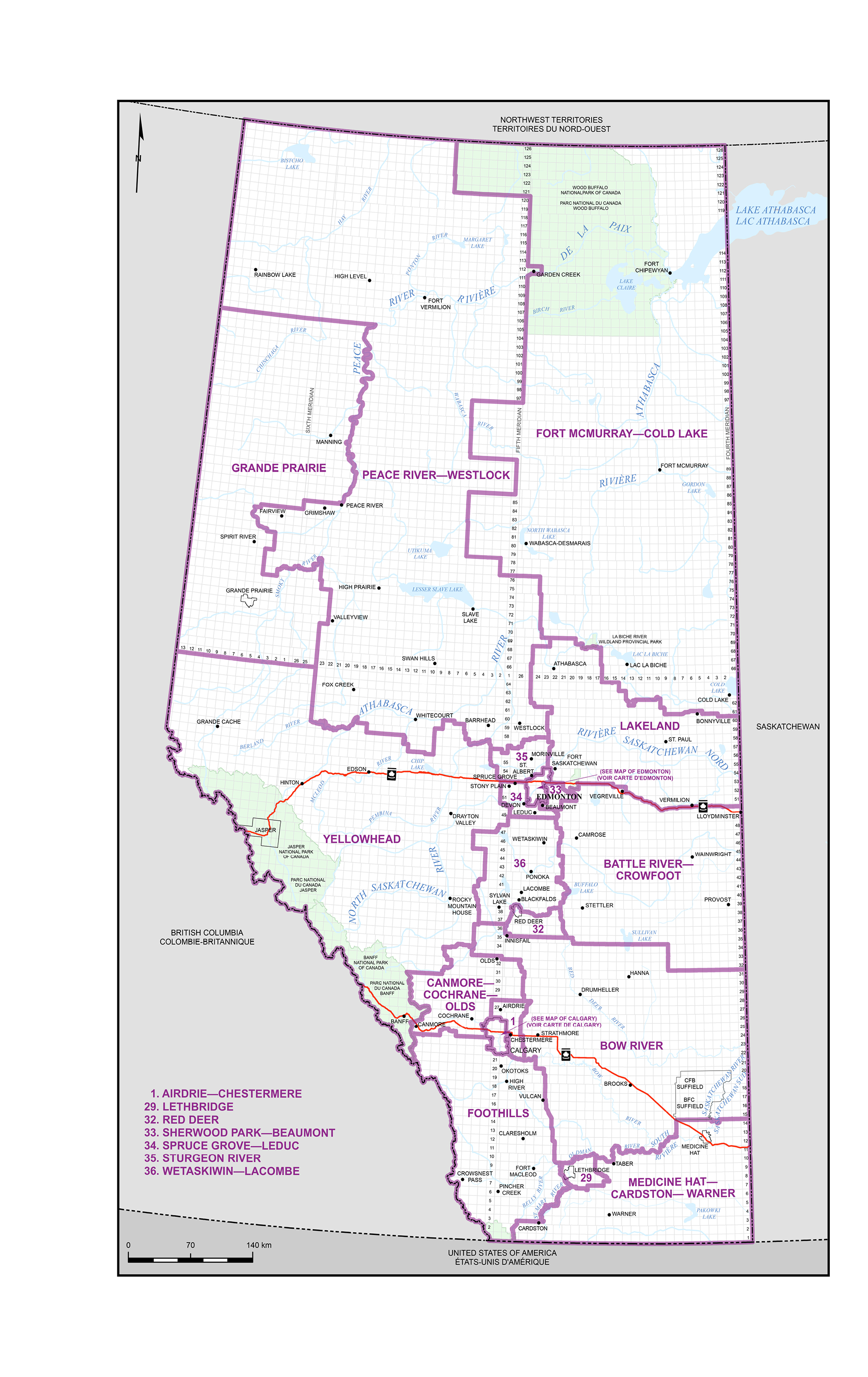
Map 2 – City of Calgary
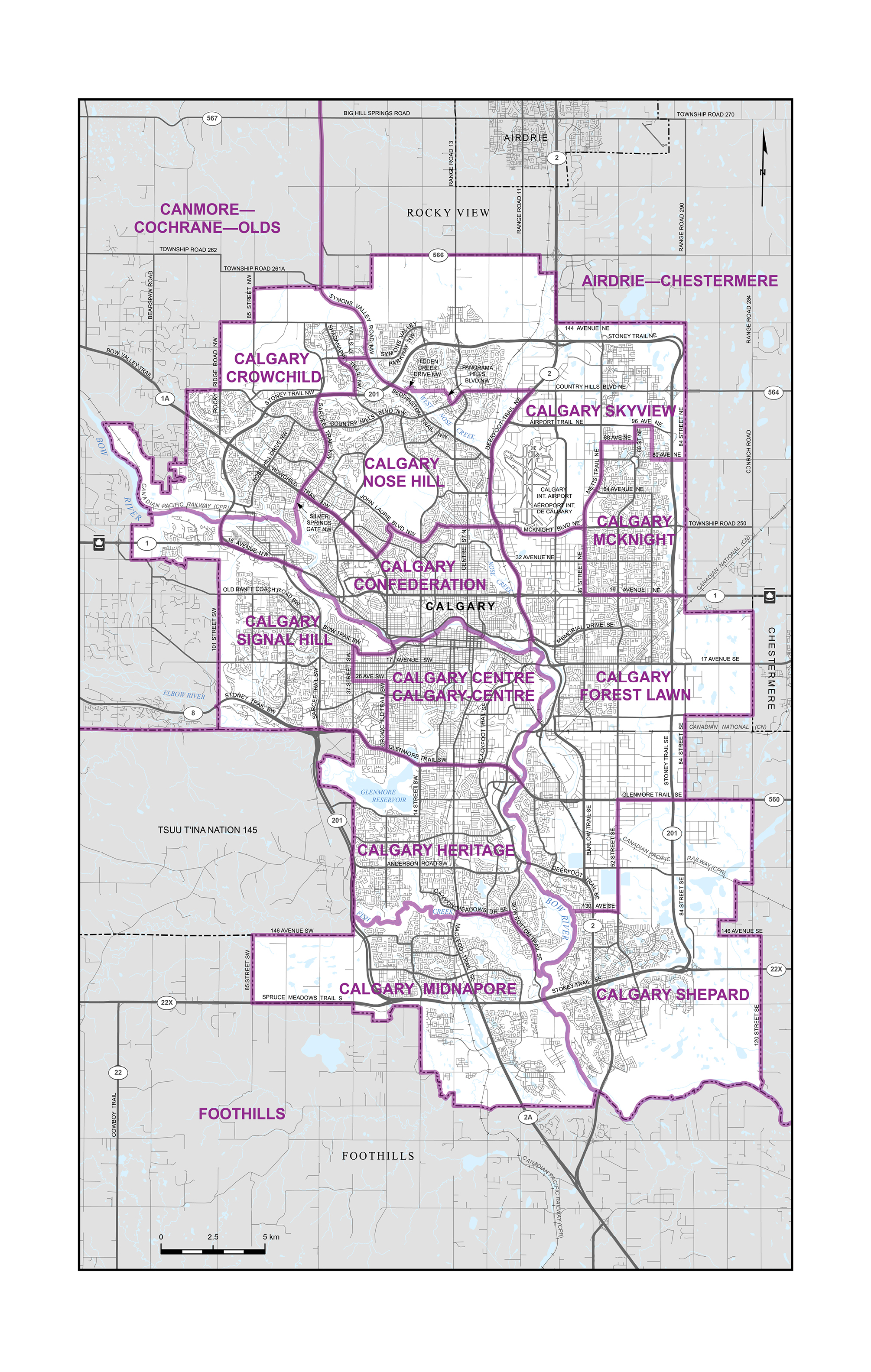
Map 3 – City of Edmonton