
Canada Gazette, Part I, Volume 158, Number 16: Vancouver International Airport Zoning Regulations
April 20, 2024
Statutory authority
Aeronautics Act
Sponsoring department
Department of Transport
REGULATORY IMPACT ANALYSIS STATEMENT
(This statement is not part of the Regulations.)
Issues
The issues being addressed by this regulatory initiative have been separated into the following three themes.
(1) Future viability and safe airport operations
In 2018, the Vancouver Airport Authority (the Airport Authority), as part of its regular review of its Master Plan (YVR 2037 Master Plan), identified the need for the construction of an additional runway in the future to accommodate predicted increases in air traffic at the Vancouver International Airport. The Airport Authority identified two possible locations for the additional runway within the current airport boundaries, with forecasts suggesting the runway would be required in approximately 30 years.
As the Vancouver International Airport is operated under a ground lease from the federal government, the Airport Authority is required to submit a land use plan to Transport Canada (TC) for approval. In the approved 2027 land use plan, the Airport Authority has reserved land on the airport property for two future runway options. However, rapid land development is taking place in the surrounding municipalities. If legal restrictions are not imposed now to protect the lands in the vicinity of the airport for the possibility of the construction of an additional runway in the future, by the time the airport needs to increase its runway capacity, the construction of high-rise buildings may impact the operational viability of an additional runway. Restricting the heights of any development now to permit the safe approach and departure of aircraft to each proposed runway option will give the airport flexibility in its development plans. Without the proposed protection for future expansion, the long-term economic viability of the airport may be impacted.
(2) Wildlife hazards and communication interference
The proposed Vancouver International Airport Zoning Regulations (proposed Regulations) would add two key restrictions that would represent important improvements to the safe operation of an airport:
- (1) prohibiting the use of lands for activities or uses that attract wildlife — particularly birds — near a flight path that may create a hazard for aviation safety.
The present Vancouver International Airport Zoning Regulations (VIAZR) currently prohibit the use of land for the disposal or accumulation of any waste material or substance edible by or attractive to birds. However, shelter and water are other major attractants for birds that need to be addressed. Birds are a serious hazard to aircraft during the critical phases of flight (take-off and landing) as they can cause severe damage to an aircraft (e.g. catastrophic engine failure, extreme damage to the aircraft) that may result in accidents or fatalities. Updating the wildlife hazard clause would enhance the safety of aviation stakeholders and citizens.
- (2) prohibiting the use of lands in a way that causes interference with any signal or communication to and from an aircraft.
The VIAZR do not contain prohibitions that would prevent land uses that would cause interferences with communications at the airport, for example building radio stations near the airport. The need to rely on instrument navigational aids during landings in poor visibility means that, for an aircraft, maintaining communications with the airport and navigational aids is critical to safety. The consequences of losing critical communication systems on final approach can be catastrophic. Adding a new prohibition would improve safety at the airport.
(3) Airport terminology
The terminology in the VIAZR does not align with the current terminology used in the document entitled Aerodromes Standards and Recommended Practices, TP 312, as it relates to the airport surfaces described in the VIAZR, and other minor references. Therefore, the VIAZR do not align with International Civil Aviation Organization (ICAO) standards and recommended practices. The proposed Regulations would align the terminology with that of the ICAO standards and recommended practices.
Background
Future viability and safe airport operations
Airport zoning regulations are an important legal means to protect the current and future viability and accessibility of an airport. They are site-specific regulations that restrict the heights of buildings, structures, and objects (including natural growth, such as trees), and certain land uses on regulated land in the vicinity of an airport, in order to prevent the lands from being used in a manner that is incompatible with the safe operation of an airport. TC considers amending or repealing and replacing airport zoning regulations when a change in the level of protection is needed, and follows the federal regulation–making process, which includes public and Indigenous consultation.
The Vancouver Airport Authority regularly reviews its operations and updates its Master Plan, which outlines the future needs of the airport, including planned expansions. Based on the forecasted growth of air traffic at the airport, the Airport Authority identified the need for the construction of an additional runway in approximately 30 years. The Airport Authority identified two possible locations for construction of an additional runway: (i) the northwest corner of the airport (Foreshore Runway); or (ii) close into the existing south runway (Close-in South Parallel Runway). The VIAZR protect the safe operations of the airport’s three existing runways, but do not contemplate possible expansions.
The Airport Authority operates the Vancouver International Airport through a long-term ground lease from TC, under which the Government of Canada retains ownership of the land. Therefore, the Airport Authority must submit a land use plan with long-term infrastructure plans to TC for approval. To maintain its status as a world-class airport and economic driver in the Vancouver area, the Airport Authority has requested that TC amend the VIAZR to account for the proposed expansion. Even though the Airport Authority’s Master Plan indicates the need for only one of the two runway options, the Airport Authority has requested that zoning areas be added for both possible runways to provide flexibility to the airport planners to select the most appropriate option when the need for expansion arises. The need for flexibility is due to the 30-year-plus time frame for possible expansion as aircraft and technology in the aviation sector may change, making one option preferable to the other.
TC, in collaboration with the Airport Authority, has engaged with the local landowners and developers, Indigenous groups, and the cities of Richmond, Vancouver, Burnaby, and Delta, who would be impacted by the proposed Regulations. TC and the Airport Authority have worked with these stakeholders to maximize the heights permissible for construction developments within the impacted areas under the proposed Regulations without compromising safety. As a result, several small, but defined, areas are proposed where taller buildings would be permitted. It should be noted that any buildings, structures and objects that exist when the proposed Regulations come into force, or any existing uses of the land, would be considered legally non-conforming, meaning that they would not be considered a violation of the proposed Regulations and no enforcement action would be needed. Any new developments contemplated after the proposed Regulations come into force would need to respect the height limits outlined in the Regulations.
Wildlife hazards and communication interference
Further to adding new surfaces and related height limits for buildings and structures, the proposed Regulations would also update other zoning restrictions to better align with today’s safety standards and practices. Since the VIAZR were last updated in 1981, bird strikes and interference with signals or communication to and from aircraft or facilities have become well-known safety hazards to airport operations.
In 1981, bird strikes were already a known hazard to aircraft operations; however, prevention was focused purely on limiting waste disposal sites. Since then, the management of wildlife has expanded to include addressing land uses that provide shelter and water to wildlife, primarily birds. Airport authorities are required to have a wildlife management plan to mitigate risks on their lands. However, where wildlife-attracting food, shelter, and water are abundant on lands outside the airport boundaries, the resulting increase in bird activity makes it difficult for airport authorities to appropriately manage the wildlife and to reduce the risk of bird strikes.
As the use of wireless technology and associated cellular towers became widespread, and as frequencies close to those reserved for aviation started to be used, communication interferences have become a known safety hazard with electronic signals sometimes crossing into the aviation bandwidth. Additionally, digital radio stations have become popular, which means that more radio signals are being broadcast. As windfarms have become more common due to a push for renewable energy, they have also been identified as a potential cause of interference. Currently, these interferences are identified through NAV CANADA assessments when instrument landing systems and navigation aids are installed, and when interference incidents are reported. Where interference is detected, NAV CANADA may need to turn off the navigational aids or redesign approaches, which impacts the usability of the airport as airlines may not be able to use these redesigned approaches in poor weather or with certain aircraft.
Airport terminology
The Aerodromes Standards and Recommended Practices (TP 312) establish the requirements for an airport’s physical characteristics, obstacle limitation surfaces (i.e. outer, approach and transitional), visual aids and technical services (refuelling, de-icing, etc.) in order to safely operate and satisfy requirements of aerodrome certification. TP 312 sets out the required level of compliance for the planning and design of airport infrastructure and service-level changes (e.g. a change from a precision to a non-precision instrument approach).
The VIAZR use the terminology from TP 312 (outer, take-off/approach and transitional surfaces) to specify the areas subject to regulatory restrictions. Figure 1 below shows a visual depiction of these surfaces.
Since the VIAZR were last amended, TP 312 has been updated with new terminology to align with ICAO standards and recommended practices, which means that the language in the VIAZR is no longer perfectly aligned with that of TP 312 or ICAO standards.
For clarity regarding the terms used in this document, the following explains the terms used and their meanings. As aircraft operate in the sky, imaginary surfaces are established to maintain safe areas and help pilots navigate. At an airport, the imaginary surfaces that must be kept clear of obstacles for safety are identified as follows:
- The outer surface is a horizontal plane at a fixed height and a radius of 4 km around the airport.
- The transitional surface inclines from each side of a runway (along the full length) until it intersects with the outer surface to offer protection for an aircraft veering off the runway centre line.
- The approach surface inclines in a triangular shape from each end of the runway out to a maximum distance of 15 km to permit an aircraft to safely adjust altitude and heading left or right for take-off and landing.
These surfaces must be kept clear of obstacles to ensure the safe operations of an aircraft into and out of an airport. They are collectively represented in this document as the “certification surfaces.”
Airport zoning regulations provide protection for the certification surfaces. The regulations use the same terminology (outer, transitional, approach) to identify the areas that are subject to the regulations. The imaginary surfaces are also known as “zoning surfaces” and they exist below the certification surfaces with a space between the two surfaces. The space provides a margin of safety that allows potential obstacle penetrations (e.g. tops of buildings or trees) to be identified before they penetrate the certification surfaces. Zoning surfaces are legal restrictions that are subject to enforcement while the certification surfaces are required to be obstacle free but cannot be protected from obstacles without the enforcement of a zoning surface.
See Figure 4(a) for a visual representation of the zoning and certification surfaces.
Objective
The objectives of the proposed Regulations are to ensure
- (1) the future viability of the Vancouver International Airport by restricting land use as well as the heights of buildings and structures, including natural growth, in the vicinity of two potential areas for future runway development;
- (2) the ongoing safe operation of the Vancouver International Airport by setting prohibitions on well-known hazards; and
- (3) alignment and consistency with current domestic and international standards and practices.
Description
The proposed Regulations would repeal and replace the VIAZR because of the complexity of the legal land descriptions and zoning plan.
Zoning areas
As with the VIAZR, the geographical locations of the zoning areas to which restrictions apply, including the maximum height permitted for these zoning areas, would be set out in a schedule to the proposed Regulations. For clarity, the imaginary surface above the zoning area (i.e. the height limit or ceiling height for a zoning area) is referred to as an “airport zoning regulation surface” or “zoning surface.”
Proposed changes to the Schedule would add new zoning areas and modify some of the zoning surfaces in a small portion of the existing zoning areas. The following provides a summary of the proposed changes as they relate to the new zoning areas. Figure 1 and Figure 2 provide a visual representation of the geographical location of the current and proposed zoning areas.
- (1) New zoning areas would be added to protect the potential Foreshore Runway and the potential Close-in South Parallel Runway. Additionally, small existing zoning areas would be modified to ensure that the transitional and approach surfaces of the Close-in South Parallel Runway are possible. The boundaries of these zoning areas are determined by considering the requirements for the airport certification and the operational surfaces — an imaginary inclined ratio-based height or ceiling — for these two runway options: the runways would have an approach surface to a distance of 1 500 m with a 2% incline (1:50), and a transitional surface with a 14.3% incline (1:7) out to a height of 45 m where it intersects with the outer surface.
- (2) Consequently, because of the new zoning areas, the description of the outer surface of the aerodrome (the imaginary surface located above and in the immediate vicinity of the airport) would be modified (Part 2 of the Schedule). The outer surface of the aerodrome would be expanded to the west to account for changes to the aerodrome’s specifications (e.g. Airport Reference Point described under Part 1 of the Schedule). The expansion of the outer surface would cover parts of the surrounding community to protect the area that is not part of the current zoning areas but has been added to the new zoning areas necessary to permit certification of the potential future runway.
Figure 1: Geographical location of current zoning areas
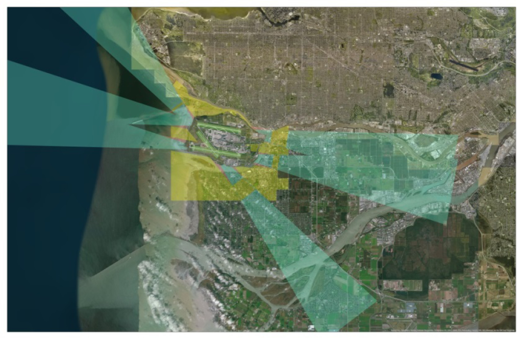
Figure Figure 1: Geographical location of current zoning areas - Text version
A satellite image centred on the Vancouver International Airport located on Sea Island in the province of British Columbia with the Pacific Ocean to the west, and the Fraser River flowing to the ocean in an east-west direction to the north and south of Sea Island, thus forming two arms converging east of Sea Island. The image shows another island (City of Richmond) to the south of the Sea Island and the mainland (City of Delta) further south; and the mainland north of Sea Island (City of Vancouver and City of Burnaby, to the east of Vancouver). The City of Richmond and the southern tip of the City of Burnaby nearly converges to the east, separated by the Fraser River. The image has an overlay of the current airport zoning regulations, visually depicting the lands to which the proposed Regulations apply. The image shows the imaginary zoning surfaces with the outer surface in yellow, the approach surface in teal, the transitional surface in red, and the three existing runways in green.
Runways: Two parallel green lines oriented in an east-west direction highlight the two main parallel runways (i.e. the north and south runways, 08L/26R and 08R/26L). One diagonal green line in a northwest-southeast direction (i.e. crosswind runway, 13/31) intersects with the bottom green line (i.e. south runway).
The approach surfaces are shown by a teal-coloured triangular-shaped overlay with the point of the triangle at both ends of each green line (i.e. runways) extending outwards over the nearby lands and waters. Two triangles represent the east end approach surfaces for the north and south runways. These triangles extend eastward from the east end of the north and south runways, and overlap to form the base of one large triangle. The northern edge of the triangle (i.e. the northern edge of the approach surface of the north runway) cuts over the southern tip of the cities of Vancouver and Burnaby and the northern Fraser River. The southern edge of the triangle (i.e. the southern edge of the approach surface of the south runway) cuts over the northwest quadrant of the City of Richmond. Two triangles represent the west end approach surfaces for the north and south runways. These two triangles extend westward from the west end of the north and south runways and overlap to form the base of one large triangle over Sea Island and the Pacific Ocean. Two other triangles represent the approach surfaces for the crosswind runway. One of these triangles extends from one end of the crosswind runway southeastward over the cities of Richmond and Delta. The other triangle extends from the other end of the crosswind runway northwestward over the West Vancouver coastline.
The transitional surfaces are shown in a comparatively small red-coloured triangular-shape overlay on both sides of the approach surfaces with the base of the triangle starting at both ends of the green lines and tip of the triangle extending approximately alongside one-eighth of both sides of the green triangle (or approach surfaces).
The outer surface is shown by a yellow-coloured irregular shape overlay around Sea Island (overlapping parts of the approach [teal] surfaces closest to the runways and encompassing the transitional surfaces [red]). The northern edge of the outer surface follows the Fraser River north of Sea Island, from the mouth of the river past the convergence of the north and south Fraser River to the southern tip of the City of Burnaby. The eastern edge of the outer surface runs angularly southward to a point in the north of the City of Richmond. The southern edge of the outer surface runs eastward in a straight line slightly past the west coastline of the City of Richmond, covering the northeast quadrant of the City of Richmond. The western edge of the outer surface runs northward in a straight line back to the starting point at the mouth of the Fraser River north of Sea Island.
Note: Yellow depicts the outer surface, teal depicts the approach surface, and red depicts the transitional surface.
Figure 2: Geographical location of the proposed zoning areas
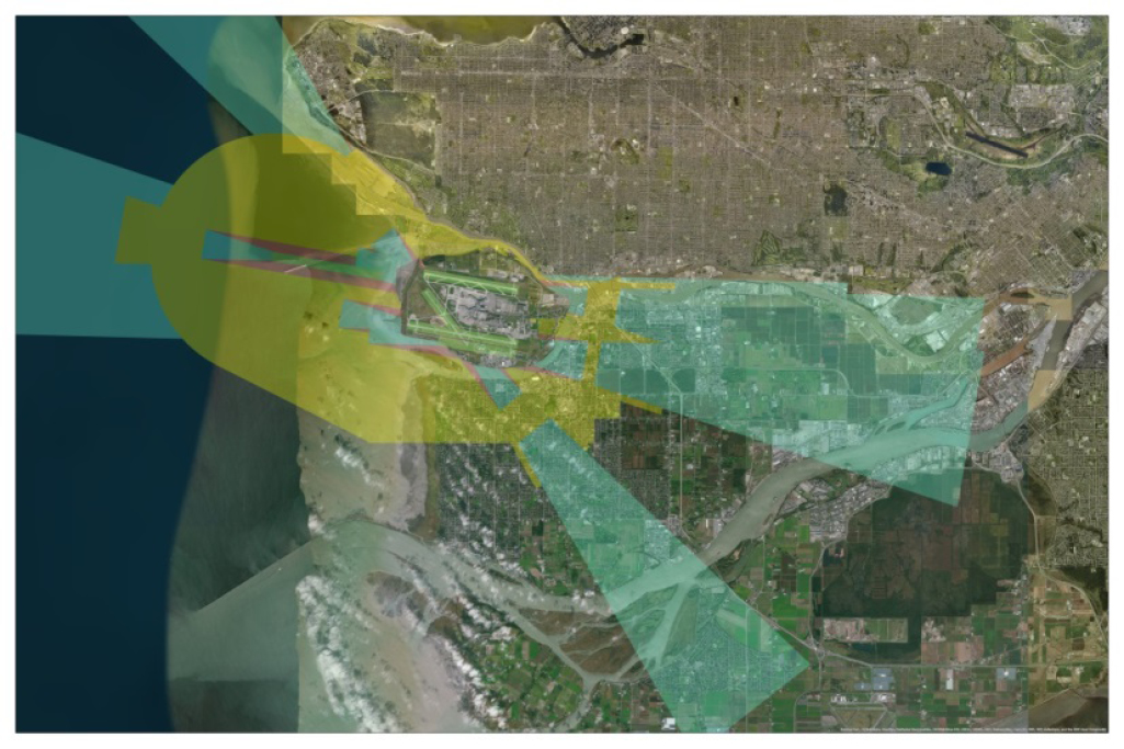
Figure 2: Geographical location of the proposed zoning areas - Text version
The same satellite image of the Vancouver International Airport located on Sea Island in Vancouver as described in Figure 1. The image has an overlay of the proposed airport zoning regulations, visually depicting the lands to which the proposed Regulations apply. The overlay shows the outer surface in yellow, the approach surface in teal, the transitional surface in red and the three runways in green. The increased area of teal and yellow shows the new areas that would be subject to the proposed Regulations.
Runways: Two green lines are shown in addition to the three green lines that highlight the three existing runways described in Figure 1 (i.e. the north and south runways and the crosswind runway). These two new lines represent the two options for a new runway. The Close-in South Parallel Runway option: A green line oriented in an east-west direction is added south and parallel to the green line representing the south runway and intersecting the south end of the crosswind runway. The Foreshore Runway option: Another green line is added, west of the north runway (approximately in line but not touching) starting from the western tip of Sea Island and extending westward over the Pacific Ocean to a certain distance.
The approach surfaces are shown by a teal-coloured triangular-shaped overlay with the point of the triangle at both ends of each green line (i.e. runways) extending outwards over the nearby lands and waters. The triangles (i.e. approach surfaces) of the two runway options overlap with the triangles of the existing runways such that only the edges of the existing triangles become slightly wider than shown in Figure 2. The northern edge of the triangle representing the northern edge of the north runway’s east end approach surface as described in Figure 1 is widened by one-eighth the original size in Figure 2. The shift of this edge represents the northern edge of the Foreshore Runway option’s east end approach surface. The southern edge of the triangles representing the southern edge of the south runway’s east-west end approach surfaces as described in Figure 1 are also widened by one-eighth the original size in Figure 2. The shift of this edge represents the southern edge of the Close-in South Parallel Runway option’s east and west end approach surfaces. The shape representing approach surfaces for the crosswind runway remains the same as described in Figure 1.
The transitional surfaces are shown in a comparatively small red-coloured triangular-shape overlay on both sides of the approach surfaces with the base of the triangle starting at both ends of the green lines and tip of the triangle extending approximately alongside one-eighth of both sides of the green triangle (approach surfaces). The red triangles (i.e. transitional surfaces) as described in Figure 1 are shown on either side of the approach surfaces for the Foreshore Runway and Close-in South Parallel Runway options as described above in Figure 2.
The outer surface is shown by a yellow-coloured irregular shape overlay around Sea Island (overlapping parts of the approach [teal] surfaces closest to the runways and encompassing the transitional surfaces[red]). The northern edge of the outer surface is as described in Figure 1, but extends further west through the southern tip of the City of Burnaby. From there, the eastern edge of the outer surface runs southward as described in Figure 1, but to a point further east than described in Figure 1 in the City of Richmond. From there, only the east side of the southern edge of the outer surface extends slightly further south into the City of Richmond than described in Figure 1, with the rest of the edge remaining the same as described in Figure 1 to a point in the mouth of the Fraser River south of Sea Island. From there, the western edge of the outer surface extends towards the northwest from the mouth of the Fraser River south of the Sea Island to a point over the Pacific Ocean and then curves back towards the mainland following the West Vancouver coastline back to the mouth of the Fraser River north of Sea Island.
These proposed new zoning areas mean that all zoning restrictions (i.e. height of objects and land uses) would be added to new areas that would be used for the approach and departure from both runway options. Modified zoning areas will have a reduced zoning surface (from a fixed height of 45 m to an inclined surface up to a height of 45 m) [see Figure 3].
Building Restrictions (section 3), Natural Growth (section 5), and Exceptions (Part 7 of the Schedule)
No changes are being proposed to the building restriction and natural growth provisions currently in effect. While the proposed Regulations would reduce the heights allowable for a small existing zoning area southeast of the airport, within the City of Richmond (Figure 3), to accommodate the approach surfaces for the proposed new runway, landowners or residents in the zoning areas of the VIAZR would not be impacted. In the small area to the southeast of the airport, the proposed reduced height limits would only apply to future developments as all existing buildings are legally non-compliant. At the time the regulatory analysis was done, none of the development plans that were identified to TC would be impacted by the reduced height limit (see the “Regulatory analysis” section below).
The proposed Regulations, however, include new zoning areas where height restrictions would be introduced. The proposed Regulations would impose a fixed height limit of 45 m above ground level in the area identified as the outer surface and a ratio-based height limit for approach and transitional surfaces, meaning that the further away from the airport a stakeholder is located along the approach and transitional surfaces, the higher the allowable height and, consequently, the lower the potential impact.
The proposed Regulations would define a small number of exception zoning areas (“bump-outs”) within the City of Richmond, where the height limit would be different from the zoning standard. In these exception areas, construction to a height higher than the zoning standard would be permitted to accommodate maximum development on specific sites already identified for development. The exceptions, as described in the proposed Regulations (Part 7 of the Schedule), reduce the margin of safety between the zoning surfaces detailed in the proposed Regulations and the imaginary surfaces that the airport is required to keep clear of obstacles in order to remain certified (Figure 4). The exception areas would not compromise safety as the certification surfaces would still need to comply with the standards in TP 312 and therefore maintain an acceptable margin of safety. These exceptions to the zoning surfaces would be described in the proposed Regulations’ zoning plans (text and drawings).
The zoning plans, which provide a visual depiction of the areas subject to restrictions, would be deposited in the local land titles office — a requirement under subsection 5.6(2) of the Aeronautics Act to allow the proposed Regulations to come into force (see the “Implementation” section for more details).
Figure 3: Lands impacted by the proposed Regulations
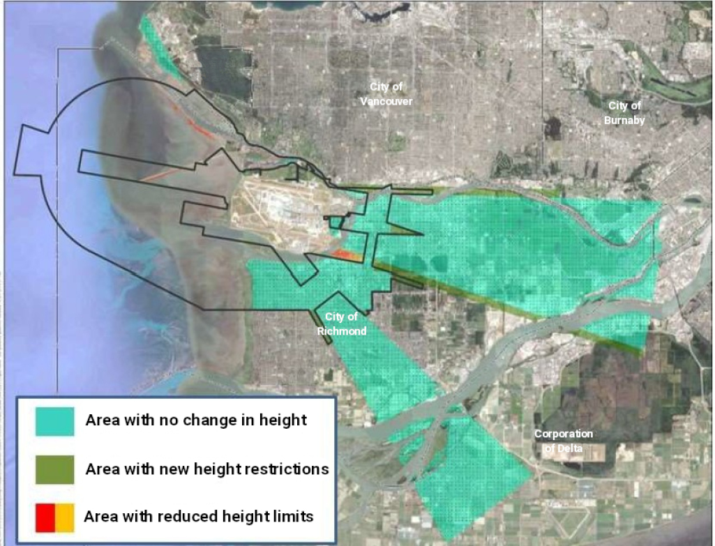
Figure 3: Lands impacted by the proposed Regulations - Text version
A satellite image of the Vancouver International Airport located on Sea Island in Vancouver as described in Figure 1. The image has an overlay of the proposed airport zoning regulations, visually highlighting the lands to which the height restrictions in the proposed Regulations would apply and what the changes would be to the east and southeast of the airport. The teal triangular overlay depicts areas with no change in height and generally follows the triangular shape as described for east end approach surfaces in Figure 1 for the south and north runways. A green strip depicts areas with new height restrictions and generally follows the shape of the extended edges of the east end approach surfaces for the Foreshore Runway and Close-in South Parallel Runway options as described in Figure 2. Areas with reduced height limits are shown by a small red and yellow strip located on the tip of the southern edge of the Close-in South Parallel Runway option’s east end approach surface as described in Figure 2.
Figure 4: Relationship between proposed airport zoning regulations (AZR) surface, certification surface and bump-outs (i.e. exceptions to the proposed height limits)
(a) Standard zoning surface without exception areas (bump-outs)
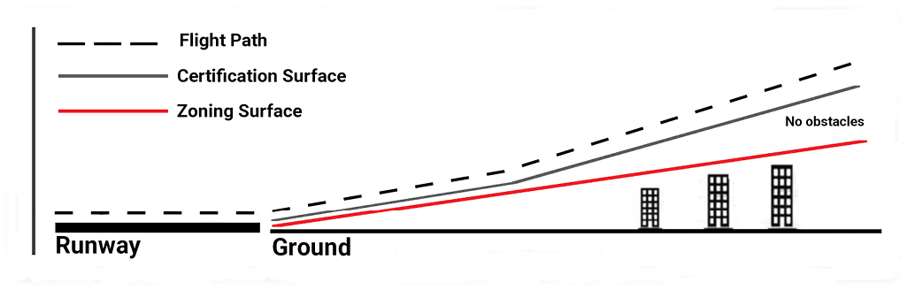
(a) Standard zoning surface without exception areas (bump-outs) - Text version
Legend: A dotted black line represents the flight path of an aircraft. A grey line represents the certification surface. A red line represents the zoning surface.
Image: The image is a two-dimensional drawing of a side view of an aircraft’s flight path during take-off or landing from a runway and above the ground with obstacles represented by buildings.
From the bottom left corner is a short thick black line representing the runway.
Next to the runway is another thinner and longer black line to the bottom right corner representing the ground after the runway.
Directly on the ground are drawings of three office buildings, each of different heights (low, medium and high) from left to right, located on the right half of the ground so that there is a gap on the ground between the end of the runway and the small building. The buildings represent obstacles.
Just above the black line (i.e. the ground), starting from the left end of the ground (or end of the runway), is a straight red line with a 15°incline to the right, passing just above the buildings, and ends in line and above the right end of the ground.
Just above the red line (i.e. zoning surface), starting from the left end of the ground (or end of the runway) is a straight grey line that runs parallel with the red line with a 15° angle to the right approximately halfway over the ground before the buildings, and then continues with a 45° angle to the right, passing above the buildings, and ends in line and above the right end of the ground. In the gap between the red and grey lines is marked “No obstacles.”
Just above the thicker black line (i.e. the runway), starting from the left end of the runway is a dotted black line that runs parallel with the runway to the end of the runway, and at the end of the runway runs just above and parallel with the grey line ending in line and above the right end of the ground.
(b) Proposed zoning surface with exception areas (bump-outs)
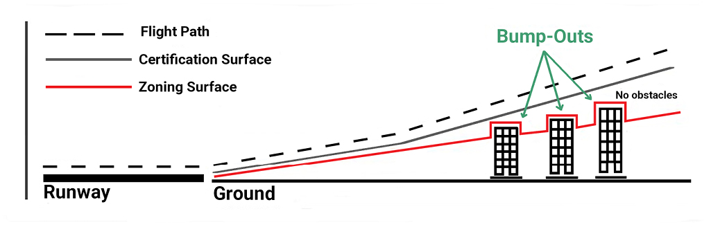
(b) Proposed zoning surface with exception areas (bump-outs) - Text version
Legend: A dotted black line represents the flight path of an aircraft. A grey line represents the certification surface. A red line represents the zoning surface.
Image: Same as described in Figure 4(a) with the following exceptions: the buildings are taller so that they would intersect with the 15°red line (zoning surface), should the red line continue to be a straight line, but are below the grey line (certification surface); the red line (zoning surface) is similar as described in Figure 4(a), except where the buildings would intersect with the line, the line closely contours the tops of the buildings to avoid intersection of the buildings, but remains below the grey line. Above the dotted black line (flight path) and above the buildings, in green font, is marked “Bump-Outs”, with three green arrows pointing downwards, stopping above the red line where it contours the tops of the three buildings.Wildlife Hazard (section 6) and Interference with Communication (section 4)
The proposed Regulations would update the provision prohibiting the use of lands for activities or uses that attract wildlife, including large open standing water ponds that attract birds, that may create a hazard for aviation safety. The proposed Regulations would, however, permit open water storage reservoirs for a period of 48 hours or less.
A new provision would be added to prohibit interference with communication to and from an aircraft or aeronautical facility. This is an important requirement for the safe operation of aircraft that rely on navigational aids and instrument approaches in poor weather as it will permit the identification and termination of signals or land uses that interfere with the signals used by these navigational aids. This provision would apply to land uses that may create interference, such as radio stations or cellular towers, particularly 5G towers. Any potential interference would need to be identified and TC made aware in order for the clause to be enforced and the interference terminated. The provision would not apply to cellphone users. No land uses were identified that would violate the proposed provision at the time TC conducted its analysis.
All lands described in the Schedule of the proposed Regulations would be subject to these new provisions, meaning that the new provisions would apply to lands covered by the VIAZR as well as the lands added to protect the proposed runway options.
Airport references and terminology
Minor changes will be made to the definitions and terms used in the proposed Regulations to reflect current usage, including those related to certain operational surfaces at airports. For example, the term and definition for “take-off/approach surface” would be changed to “approach.” These changes are non-substantive clarifications and are not expected to have appreciable impacts on affected stakeholders.
Regulatory development
Consultation
Beginning in 2014, after identifying the need to amend or replace the VIAZR, TC, in collaboration with the Airport Authority, had many discussions regarding the proposed height limit with the surrounding municipalities, land developers and Indigenous communities to understand and address any concerns. The discussions resulted in the inclusion of exception areas in the proposed Regulations, which permit the construction of taller buildings in five specific areas to address concerns from land developers who wanted to build in those areas with maximum flexibility. The exception areas permit taller developments without compromising the safety of current and future airport operations as the airports will continue to comply with the Canadian Aviation Regulations and TP 312, which set the requirements for the safe operations at an airport (i.e. the buildings would not penetrate the certification surface, and the margin of safety between the zoning and certification surfaces would be maintained).
In February and April 2021, TC consulted with the City of Delta, the City of Richmond, the City of Burnaby, and the City of Vancouver. No concerns were raised about the proposed height limit. Comments were received from all the municipalities requesting clarification on what would be restricted by the prohibition on wildlife attractants and interference with communications.
Regarding the proposed prohibition on wildlife attractants, municipalities were concerned that the restrictions would impact their ability to manage stormwater and make their cities less attractive and liveable by limiting the number of ponds and parks they could establish. These municipalities also wanted clarification on how to respect the restriction on stormwater management ponds and waste disposal facilities. In response, TC is developing an advisory circular with additional non-regulatory guidance on what land uses might be attractive to wildlife and anticipates publishing the advisory circular on its website by early 2024. The restriction would not prevent the establishment of parks or the management of stormwater but would require a municipality to look at other methods of managing stormwater, such as underground storage or grass and reed covered ponds. Open water ponds would not be permitted in the areas around the airport specified by the proposed Regulations without mitigations that would reduce their attractiveness to birds.
Regarding the proposed prohibition on interference with communications at airports, TC provided municipalities with information on how communication interferences are identified and addressed. This prohibition applies to a person who uses any land that would cause interference with communication signals and is primarily applicable to radio stations or cell towers (particularly 5G). No concerns were raised by the municipalities. Furthermore, TC does not anticipate any concerns to be raised by other stakeholders as existing uses are considered legally non-conforming, NAV CANADA has not reported any current interference, and TC is not aware of any proposals that would cause interference.
A notice was published twice in local newspapers (The Vancouver Sun, Ming Pao, La Source), including publication in two successive issues in three local newspapers (Richmond News, Burnaby Now, The Delta Optimist), between September 5 and 19, 2022, as required under subsection 5.5(1) of the Aeronautics Act, informing local residents of TC’s intent to repeal the VIAZR and replace it with the proposed Regulations, and inviting local residents to submit written comments by mail or through TC’s online consultation portal Let’s Talk Transportation from July 4, 2022, to November 6, 2022. TC did not receive any comments. TC does not anticipate any concerns from local communities or landowners/land developers regarding the proposed Regulations.
Modern treaty obligations and Indigenous engagement and consultation
In accordance with the Cabinet Directive on the Federal Approach to Modern Treaty Implementation, an analysis was undertaken to determine whether the proposed Regulations are likely to give rise to modern treaty obligations. This assessment examined the geographic scope and subject matter of the proposal in relation to modern treaties in effect and after examination no treaty implications were identified.
TC also reached out directly to the Musqueam Indian Band, which does not have a modern treaty, but some of their lands fall within the proposed zoning areas. TC contacted the Musqueam Indian Band by letter in 2021 notifying them of TC’s intent to regulate and consult, and again by letter on July 20, 2022, referring them TC’s online consultation portal and requesting that they contact TC by email or phone if they had any comments or concerns. No comments were received. TC is also aware that the Airport Authority has a longstanding friendship agreement with the Musqueam First Nation and the Airport Authority continues to consult with them on the plans for an additional runway. TC does not anticipate any negative comments regarding the proposed Regulations.
Instrument choice
The Airport Authority, as part of its responsibilities under its ground lease, is required to maintain the economic viability of the airport and plan for and obtain TC approval for future operations. The Airport Authority has identified that the increasing traffic volumes will require the airport to increase capacity by constructing an additional runway in a 30 year plus time frame. There is a need to protect runway options now given the increasing encroachment of developments in the surrounding cities, which would eventually prohibit the construction of a new runway if no protection is provided.
The Airport Master Plan identifies two future runway options: one located to the west of Sea Island in the foreshore; the other located south of the existing south runway (08R/26L). As each runway option provides different operational benefits to the airside system, the airport wants to protect for either option to allow future airport planners to choose the one that provides the best benefit for the type of operations they want to accommodate. TC supports protecting both options due to the rapid vertical development taking place in the surrounding municipalities, the geographic limitations of the airport that restricts the options for future growth and the flexibility required by the extended time frame for expansion. If protection is not provided now for potential growth, there will likely be no growth options in the future.
Airport operators are required to adhere to the standards laid out in TP 312, which include maintaining approach paths and an outer surface that are free from obstacles. Any future runway constructed will be required to meet these standards with certification surfaces that extend well beyond the boundaries of the airport property, even though the airport has control only over airport lands. Without restrictions placed on the lands that would be under the future certification surfaces for the potential runways, it is likely that the rapid development in the surrounding municipalities will mean that the runway, when constructed, would not be able to meet certification standards in TP 312.
Municipalities have limited authority to regulate land use for aeronautical purposes as it is in federal jurisdiction, and they therefore generally cannot provide protections to the airport. Only the federal government may establish regulations preventing lands adjacent to or in the vicinity of an airport or airport site from being used or developed in a manner that is, in the opinion of the Minister of Transport, incompatible with the safe operation of an airport or aircraft.
Non-regulatory options were therefore not considered as airport zoning regulations are the principal legal means to protect the current and future viability and accessibility of an airport by restricting land use in the vicinity of an airport.
Regulatory analysis
The proposed Regulations would designate a new ceiling height with additional zoning restrictions such as a prohibition on uses or developments that interfere with communication to and from aircraft and a prohibition on uses or activities that attract wildlife that may create a hazard for aviation safety. This could result in limitations on design and construction of stormwater management wet ponds or waste facilities in selected areas of the cities of Richmond, Vancouver, Burnaby, and Delta. In anticipation of the possible construction of a new runway, the proposed Regulations are designed to ensure continued aviation safety by preventing well-known safety hazards to airport operations.
Analytical framework
The costs and benefits for the proposed Regulations have been assessed in accordance with the Treasury Board Secretariat (TBS) Policy on Cost-Benefit Analysis by comparing the baseline scenario against the regulatory scenario. The baseline scenario depicts what is likely to happen in the future if the Government of Canada does not implement the proposed Regulations. The cost-benefit analysis represents the periods between 2025footnote 1 and 2053 in line with the Airport Authority’s proposed anticipated timeline for runway construction. The baseline scenario is defined as the current regulatory boundaries remaining unchanged within the analytical time frame; whereas, the regulatory scenario includes new height restrictions, limitations on stormwater management system types, and restrictions on electronic communications equipment. As part of the analysis, TC recognizes the potential existence of opportunity costs since the implementation of restrictions through the proposed Regulations could lead to the possible loss of future positive socio-economic externalities in the form of the restriction that they impose on the possibility of the future high-rise development and hence the diminishing number of available units. This is discussed in the costs section below.
Affected stakeholders
The proposed Regulations would apply to the areas around the airport. Among the main affected stakeholders, commercial property developers within the new zoning areas would be required to abide by the new height restrictions. Likewise, the cities of Richmond, Vancouver, Burnaby, and Delta would be required to consider the new land-use restrictions in their urban planning. For example, the design and implementation of certain urban features, such as parks or water management systems, would need to meet the new standards in all affected areas to prevent new attractants for wildlife, particularly birds that pose safety hazards for landing and departing aircraft.
Any buildings, structures, objects, or land uses that exist or have all required approvals for development or construction when the proposed Regulations come into force would be considered legally non-conforming and thus would not be required to abide by the proposed Regulations.
While airport zoning areas overlap with Indigenous wildlife harvesting and fishing areas, the proposed Regulations would not cause any additional burden. This is because the proposed Regulations would substantially cover the same harvesting areas as the VIAZR do. Furthermore, the proposed Regulations cover a heavily urbanized areas, where very little harvesting occurs. Therefore, any harvesting activities that do occur (e.g. plant gathering near the banks of the Fraser River) would not be affected by the proposed Regulations. With respect to the fishing areas, Indigenous fishing rights will be unaffected by the proposed Regulations as well.
Benefits and costs
The proposed Regulations would protect the future viability of the two runway options identified. Even though it is likely that only one of the two runway options will be selected, TC has made the decision to add zoning protection for both runway sites to provide flexibility to airport planners to select either option. The proposed Regulations would ensure that should the Airport Authority decide to construct another runway, the option would remain available. As the proposed Regulations would not constitute approval for the construction of an additional runway at present (they would only ensure that construction is possible in the future), the benefits and costs of the decision/approval are not in scope of this analysis.
Costing considerations
The following factors were taken into consideration in analyzing the possible impact of the zoning areas: the role and impact of legally non-conforming uses, electronic communications equipment, preceding agreements, substitution and the availability of alternative designs, bump-out exceptions and opportunity costs. A summary of these factors is provided below.
Legally non-conforming uses
The proposed Regulations would restrict the height of localized buildings or obstacles, as well as restrict potential uses of the affected zoning areas. Structures such as stormwater management wet ponds or waste facilities that may attract wildlife would not be permitted to be built within the areas affected by the proposed Regulations. All existing buildings, structures, objects, and land uses, as well as fully permitted plans to construct or modify buildings, structures, and objects or to modify land uses within the newly affected area, would be considered legally non-conforming, and adherence to the proposed Regulations would not be required. Therefore, no incremental costs would be carried (see further details under the “Exceptions” section below).
Electronic communications equipment
As mentioned in the “Consultation” section, no concerns were raised by the stakeholders with respect to any future plans for installation of electronic communications equipment and any other interfering apparatuses (i.e. windfarms). Therefore, no incremental impacts between the baseline and regulatory scenarios are anticipated.
Preceding agreements
Of the five areas of consideration (City Centre in the City of Richmond, Marpole in the City of Vancouver, East Fraser Lands in the City of Vancouver, Big Bend in the City of Burnaby, City of Delta) where the proposed Regulations would impose additional restrictions, there are no immediate planned constructions in motion or approved or permitted that would appear to conflict with the proposed Regulations. The plans of one building site in the City of Richmond were adjusted after an agreement was reached among all stakeholders (e.g. developers, the municipality, and the Airport Authority). Therefore, there are no changes between baseline and regulatory scenarios and hence no foreseeable action that would be in violation of the proposed Regulations. The project was revised preceding TC’s engagement and therefore prior to the proposed Regulations being registered. As a result, the impacts are not considered for the cost-benefit analysis.
Substitution and availability of alternative designs
Additionally, in relation to anticipated restrictions, other modification options would be available that would not impose any additional costs and/or inconvenience. For example, the proposed Regulations would prohibit the construction of standing open water management systems. However, it was determined through consultation with appropriate specialists and stakeholders that there are many other available technologies and approach substitutes (i.e. vegetated filter strips, permeable pavements, sand filter basins) that can yield the same outcome with no appreciable difference in cost. Regarding recreational enjoyment of water facilities, such as storm ponds, through activities such as birdwatching, any loss of enjoyment would be negligible due to the proximity to the Fraser River (see Figure 3), where similar recreational activities can be enjoyed. The Fraser River is a major water source in the region, offering scenic and natural amenities to the residents of the area.
Exceptions
Furthermore, it is important to note that under the proposed Regulations, any existing structures or facilities previously considered legally non-conforming (i.e. legally exceeding the height restriction within the VIAZR), or buildings within the new proposed areas that exceed the proposed height would be able to remain at their current height and therefore would not be required to be modified or removed to be in compliance with the proposed Regulations. However, any further increase in the height of these legally non-conforming buildings after the proposed Regulations come into force would likely be considered in violation of the Regulations. For example, a building considered legally non-conforming would likely not be able to have anything constructed on the roof that would increase the height of the building further.
Opportunity costs
As a result of the height limit restrictions on buildings in the proposed Regulations, there could be opportunity costs associated with a decrease in the number of housing units offered and loss of future positive socio-economic externalities. These positive externalities include limiting urban sprawl and commute pollution, and diversification of the neighbourhoods. However, based on past development trends, in particular those in the City of Richmond, low-rise condo developments have been the dominant development choice. This has mostly been because the existing regulations (City of Richmond Bylaw 10154) limit building height to 45 m in the Richmond city centre. Therefore, it is unlikely that there would be any major departure from the existing norms in the future in the Richmond city centre, which would make any assumptions regarding the opportunity costs unrealistic and non-quantifiable. With respect to other affected areas, the height restrictions in the other regions due to the proposed Regulations are currently above the average build height in their respective zones. TC is aware of the potential for changing development trends in the future resulting in more significant opportunity costs; however, the analysis could only be based on currently available information and data. Any assumed departure from current trends would not be evidence-based, and therefore would be speculative in nature.
Small business lens
Analysis under the small business lens determined that the proposed Regulations would not impact Canadian small businesses.
One-for-one rule
The one-for-one rule does not apply to the proposed Regulations, as there would be no incremental change in the administrative burden on business.
Regulatory cooperation and alignment
The proposed Regulations are not related to any work plan or commitment under a formal regulatory cooperation forum (e.g. the Canada–United States Regulatory Cooperation Council, the Canadian Free Trade Agreement Regulatory Reconciliation and Cooperation Table, the Canada-European Union Comprehensive Economic and Trade Agreement Regulatory Cooperation Forum).
Strategic environmental assessment
In accordance with the Cabinet Directive on the Environmental Assessment of Policy, Plan and Program Proposals, a preliminary scan was conducted and it was concluded that a strategic environmental assessment is not required.
The proposed Regulations would ensure that an additional runway is possible and do not constitute approval for construction. The Airport Authority anticipates that a likely timeline for an additional runway will be in 30 or more years. It may be difficult to meaningfully assess the impact in that time frame, given evolving technology in electric engines and sustainable fuels. Additional consultation with the local community and environmental assessments by the Impact Assessment Agency of Canada would be required before the Airport Authority is permitted to construct the runway.
Gender-based analysis plus
While the air transport sector continues to be a male-dominated industry, the proposed Regulations are not expected to have differential impacts on the basis of identity factors such as sex, gender, age, language, education, culture, ethnicity, income, ability, sexual orientation, or gender identity. The proposed Regulations are site-specific restrictions on land use and the heights of buildings, structures and objects (including natural growth, such as trees) in the vicinity of the Vancouver International Airport.
Overall, the proposed Regulations are not expected to have differential impacts on communities around the airport. Consultations with residents did not identify any concerns. Residents in the areas in which height restrictions would apply would likely not be impacted given that the proposed height limit for buildings, structures and natural growth is high for the average homeowner. Land developers and owners of taller buildings, such as high-rises, would be impacted; however, steps have been taken to minimize this impact.
The new provisions concerning the prevention of wildlife hazards and communication interference would apply to the new and old areas covered and would have limited impact on most residents living in the affected area as they apply to stormwater management ponds, waste disposal facilities and electronic signals. For example, municipalities would be required to consider options that do not attract birds or pose other wildlife hazards to manage stormwater and waste disposal that serve their residents. The impact is expected to be the same for all stakeholders and no individual groups were identified as being disproportionately affected.
Implementation, compliance and enforcement, and service standards
Implementation
As prescribed in subsection 5.6(2) of the Aeronautics Act, the proposed Regulations would come into force on the day on which a copy of the proposed Regulations, zoning plans (signed by the Minister and local land surveyor duly licensed) and a legal description of the lands for the proposed Regulations are deposited in the local land titles office. After publication in the Canada Gazette, Part II, the proposed Regulations would be published on the Department of Justice (DoJ) Justice Laws website, with a note that they are not in force. As per a signed commitment agreement between TC and the Airport Authority, the Airport Authority is responsible for ensuring that the documentation is deposited as required and would inform TC when the deposit is done. TC would advise DoJ when the zoning plans are deposited in the land titles office at which point the coming into force will be listed on the DoJ website as the day of deposit. The Airport Authority will deposit the required documentation as soon as possible once the proposed Regulations are passed and the plan and description of the lands are signed by the Minister and a land surveyor licensed in British Columbia.
Compliance
TC is responsible for oversight of the airport and enforcing the proposed Regulations. The Airport Authority would be responsible for monitoring the lands around the airport for compliance and for reporting any potential violations or issues to TC. This responsibility is set out in a commitment agreement between TC and the Airport Authority.
Enforcement
The Minister of Transport may, in accordance with subsection 5.7(1) [Notice of entry to enforce compliance] of the Aeronautics Act, give written notice to advise the owner or lessee of lands subject to the airport zoning regulation that they are making use of lands or buildings, structures, or objects in contravention of the zoning regulation. The notice would indicate that, unless the owner or lessee of the lands removes the portion of the building, structure or object that does not comply with the height or land use restriction, or discontinues the contravening use, the Minister may take action to ensure its removal.
Contravening an airport zoning regulation may also be enforced as an offence by way of summary conviction under subsection 7.3(3) of the Aeronautics Act. The fines for these offences are $5,000 for an individual and $25,000 for a corporation.
Contact
Jamie Johnson
Regional Director
Civil Aviation
Transport Canada
800 Burrard Street, Unit 820
Vancouver, British Columbia
V6Z 2J8
Email: aviation.pac@tc.gc.ca
PROPOSED REGULATORY TEXT
Notice is given, under subsection 5.5(1)footnote a of the Aeronautics Act footnote b, that the Governor in Council proposes to make the annexed Vancouver International Airport Zoning Regulations under paragraphs 5.4(2)(b)footnote a and (c)footnote a of that Act.
Interested persons may make representations concerning the proposed Regulations to the Minister of Transport within 60 days after the date of publication of this notice. All such representations must cite the Canada Gazette, Part I, and the date of publication of this notice, and be sent to Jamie Johnson, Regional Director of Civil Aviation, Transport Canada, 800 Burrard Street, Unit 820, Vancouver, British Columbia V6Z 2J8 (tel: 1‑866‑995‑9737; email: aviation.pac@tc.gc.ca).
Ottawa, April 11, 2024
Wendy Nixon
Assistant Clerk of the Privy Council
Vancouver International Airport Zoning Regulations
Interpretation
Definitions
1 The following definitions apply in these Regulations.
- airport
- means the Vancouver International Airport, in the City of Richmond, in the Province of British Columbia. (aéroport)
- airport reference point
- means the point described in Part 1 of the schedule. (point de référence de l’aéroport)
- approach surface
- means an imaginary inclined surface that extends upward and outward from each end of a strip surface and that is described in Part 2 of the schedule. (surface d’approche)
- outer surface
- means the imaginary surface that is located above and in the immediate vicinity of the airport and is described in Part 3 of the schedule. (surface extérieure)
- strip surface
- means an imaginary surface that is associated with a runway, including a proposed runway or runway extension, and is described in Part 4 of the schedule. (surface de bande)
- transitional surface
- means an imaginary inclined surface that extends upward and outward from the lateral limits of a strip surface and its approach surfaces and that is described in Part 5 of the schedule. (surface de transition)
- zoning plan
- means Plan EPP113242 (Sheets 1 to 23). (plan de zonage)
Application
Lands near airport
2 These Regulations apply in respect of all lands that are adjacent to or in the vicinity of the airport and that are within the limit described in Part 6 of the schedule. For greater certainty, the lands include lands under water and public road allowances.
Building Restrictions
Prohibition — maximum height
3 A person must not place, erect or construct, or permit another person to place, erect or construct, on any of the lands, a building, structure or object, or an addition to an existing building, structure or object, any part of which would penetrate any of the following surfaces:
- (a) an approach surface;
- (b) the outer surface; or
- (c) a transitional surface.
Interference with Communication
Prohibition — interference
4 A person must not use or develop, or permit another person to use or develop, any of the lands that are under any of the following surfaces in a manner that causes interference with any signal or communication to and from an aircraft or to and from any facility used to provide services relating to aeronautics:
- (a) an approach surface;
- (b) the outer surface; or
- (c) a transitional surface.
Natural Growth
Prohibition — maximum height
5 A person must not permit any object of natural growth that is on any of the lands to grow in such a manner as to penetrate any of the following surfaces:
- (a) an approach surface;
- (b) the outer surface; or
- (c) a transitional surface.
Wildlife Hazard
Prohibition — activities or uses
6 (1) A person must not use, or permit another person to use, any of the lands in respect of which these Regulations apply for activities or uses that attract wildlife — particularly birds — that may create a hazard for aviation safety.
Exception
(2) Despite subsection (1), a person may use, or permit another person to use, the lands as a site for an open water storage reservoir for a period of 48 hours or less.
Repeal
7 The Vancouver International Airport Zoning Regulations footnote 2 are repealed.
Coming into Force
Requirements — subsection 5.6(2) of Aeronautics Act
8 These Regulations come into force on the day on which the requirements prescribed in subsection 5.6(2) of the Aeronautics Act are met.
SCHEDULE
(Sections 1 and 2)
In this schedule, all grid coordinates are in metres (m) and refer to the North American Datum 1983 (NAD83), Canadian Spatial Reference System, Zone 10, Universal Transverse Mercator (UTM) projection. Grid coordinates have been computed using a combined average scale factor of 0.9996026216. All distances referenced are UTM grid distances.
In this schedule, all elevation values are in metres (m) and refer to the Canadian Geodetic Vertical Datum of 2013 (CGVD2013).
PART 1
Airport Reference Point
The airport reference point, as shown on the zoning plan, is a point distant 557.914 m measured northerly at a right angle to the projected centre line of runway 08R-26L from a point distant 586.008 m measured easterly along the projected centre line from threshold 08R, having grid coordinates of 484 378.735 E and 5 449 259.883 N, and an assigned elevation of 2.100 m.
PART 2
Approach Surfaces
The elevation of an approach surface at any point is equal to the elevation of the nearest point on the centre line of that approach surface. The elevation of an approach surface centre line is calculated from the elevation of the abutting end of the strip surface, increasing at the constant ratios set out in this Part.
Subject to the exceptions set out in Part 7, the approach surfaces, as shown on the zoning plan, are described as follows:
- (a) an imaginary inclined surface abutting the 08R end of the strip surface associated with runway 08R-26L, consisting of an inclined surface having a ratio of 1 m measured vertically to 50 m measured horizontally, rising to the outer edge of the approach surface drawn at right angles to the projected centre line of the strip surface and distant 15 000 m measured horizontally from the end of the strip surface; the outer edge having a length of 2 400 m on either side of the projected centre line and a height of 300 m above the elevation at the end of the strip surface;
- (b) an imaginary inclined surface abutting the 26L end of the strip surface associated with runway 08R-26L, consisting of an inclined surface having a ratio of 1 m measured vertically to 50 m measured horizontally, rising to the outer edge of the approach surface drawn at right angles to the projected centre line of the strip surface and distant 15 000 m measured horizontally from the end of the strip surface; the outer edge having a length of 2 400 m on either side of the projected centre line and a height of 300 m above the elevation at the end of the strip surface;
- (c) an imaginary inclined surface abutting the 08L end of the strip surface associated with runway 08L-26R, consisting of an inclined surface having a ratio of 1 m measured vertically to 50 m measured horizontally, rising to the outer edge of the approach surface drawn at right angles to the projected centre line of the strip surface and distant 15 000 m measured horizontally from the end of the strip surface; the outer edge having a length of 2 400 m on either side of the projected centre line and a height of 300 m above the elevation at the end of the strip surface;
- (d) an imaginary inclined surface abutting the 26R end of the strip surface associated with runway 08L-26R, consisting of an inclined surface having a ratio of 1 m measured vertically to 50 m measured horizontally, rising to the outer edge of the approach surface drawn at right angles to the projected centre line of the strip surface and distant 15 000 m measured horizontally from the end of the strip surface; the outer edge having a length of 2 400 m on either side of the projected centre line and a height of 300 m above the elevation at the end of the strip surface;
- (e) an imaginary inclined surface for runway 09R, consisting of the following two surfaces:
- (i) the first surface abutting the 09R end of the strip surface associated with runway 09R-27L, consisting of an inclined surface having a ratio of 1 m measured vertically to 50 m measured horizontally, rising to the outer edge of the first surface of the approach surface drawn at right angles to the projected centre line of the strip surface, with the southern point of the outer edge having grid coordinates of 477 256.56 E and 5 448 174.55 N with a height of 168.32 m above the elevation at the end of the strip surface, and with the northern point of the outer edge having grid coordinates of 477 654.30 E and 5 450 987.53 N with a height of 170.26 m above the elevation at the end of the strip surface, and
- (ii) the second surface with the southern point of the inner edge having grid coordinates of 471 973.05 E and 5 448 310.60 N with a height of 272.85 m above the elevation at the 09R end of the strip surface, and with the northern point of the inner edge having grid coordinates of 472 887.19 E and 5 452 585.96 N with a height of 269.70 m above the elevation at the end of the strip surface, consisting of an inclined surface having a ratio of 1 m measured vertically to 50 m measured horizontally, rising to the outer edge of the approach surface drawn at right angles to the projected centre line of the strip surface and distant 15 000 m measured horizontally from the end of the strip surface; the outer edge having a length of 2 400 m on either side of the projected centre line and a height of 300 m above the elevation at the end of the strip surface;
- (f) an imaginary inclined surface abutting the 27L end of the strip surface associated with runway 09R-27L, consisting of an inclined surface having a ratio of 1 m measured vertically to 50 m measured horizontally, rising to the outer edge of the approach surface drawn at right angles to the projected centre line of the strip surface and distant 15 000 m measured horizontally from the end of the strip surface; the outer edge having a length of 2 400 m on either side of the projected centre line and a height of 300 m above the elevation at the end of the strip surface;
- (g) an imaginary inclined surface for runway 09L, consisting of the following two surfaces:
- (i) the first surface abutting the 09L end of the strip surface associated with runway 09L-27R, consisting of an inclined surface having a ratio of 1 m measured vertically to 50 m measured horizontally, rising to the outer edge of the first surface of the approach surface drawn at right angles to the projected centre line of the strip surface, with the southern point of the outer edge having grid coordinates of 477 625.46 E and 5 450 783.50 N with a height of 53.65 m above the elevation at the end of the strip surface, and with the northern point of the outer edge having grid coordinates of 477 781.01 E and 5 451 883.65 N with a height of 54.41 m above the elevation at the end of the strip surface, and
- (ii) the second surface with the southern point of the inner edge having grid coordinates of 472 529.85 E and 5 450 914.68 N with a height of 154.47 m above the elevation at the 09L end of the strip surface, and with the northern point of the inner edge having grid coordinates of 473 074.45 E and 5 453 461.76 N with a height of 152.59 m above the elevation at the end of the strip surface, consisting of an inclined surface having a ratio of 1 m measured vertically to 50 m measured horizontally, rising to the outer edge of the approach surface drawn at right angles to the projected centre line of the strip surface and distant 15 000 m measured horizontally from the end of the strip surface; the outer edge having a length of 2 400 m on either side of the projected centre line and a height of 300 m above the elevation at the end of the strip surface;
- (h) an imaginary inclined surface abutting the 27R end of the strip surface associated with runway 09L-27R, consisting of an inclined surface having a ratio of 1 m measured vertically to 50 m measured horizontally, rising to the outer edge of the approach surface drawn at right angles to the projected centre line of the strip surface and distant 15 000 m measured horizontally from the end of the strip surface; the outer edge having a length of 2 400 m on either side of the projected centre line and a height of 300 m above the elevation at the end of the strip surface;
- (i) an imaginary inclined surface abutting the 13 end of the strip surface associated with runway 13-31, consisting of an inclined surface having a ratio of 1 m measured vertically to 50 m measured horizontally, rising to the outer edge of the approach surface drawn at right angles to the projected centre line of the strip surface and distant 15 000 m measured horizontally from the end of the strip surface; the outer edge having a length of 2 400 m on either side of the projected centre line and a height of 300 m above the elevation at the end of the strip surface; and
- (j) an imaginary inclined surface abutting the 31 end of the strip surface associated with runway 13-31, consisting of an inclined surface having a ratio of 1 m measured vertically to 50 m measured horizontally, rising to the outer edge of the approach surface drawn at right angles to the projected centre line of the strip surface and distant 15 000 m measured horizontally from the end of the strip surface; the outer edge having a length of 2 400 m on either side of the projected centre line and a height of 300 m above the elevation at the end of the strip surface.
PART 3
Outer Surface
The outer surface, as shown on the zoning plan, is an imaginary surface situated at a constant elevation of 45 m above the airport reference point, but at 9 m above the ground when that elevation would place the outer surface at less than 9 m above the ground.
Subject to the exceptions set out in Part 7, the limit of the outer surface, in the Cities of Richmond and Vancouver, is described as follows:
- commencing at the southeastern corner of Lot 143, Section 13, Block 4 North, Range 7 West, New Westminster District, Plan 26911;
- thence on an azimuth of 270°01′51″ for 2 132.18 m more or less to the southeastern corner of Section 16, Block 4 North, Range 7 West, New Westminster District;
- thence on an azimuth of 270°00′26″ for 727.64 m more or less to the southwestern corner of Parcel B (Reference Plan 77), Sections 99 and 16, Block 4 North, Range 7 West, New Westminster District;
- thence on an azimuth of 270°00′41″ for 1 778.26 m more or less to a point having grid coordinates of 483 476.49 E and 5 444 777.03 N;
- thence on an azimuth of 359°57′46″ for 48.42 m more or less to a point having grid coordinates of 483 476.46 E and 5 444 825.44 N;
- thence on an azimuth of 296°48′58″ for 5 443.11 m more or less to a point having grid coordinates of 478 618.70 E and 5 447 280.98 N;
- that point being the beginning of a horizontal curve, whose radius of 4 000 m more or less has an azimuth of 26°48′58″, to a radial point having grid coordinates of 480 423.21 E and 5 450 850.82 N;
- thence along said curve through a central angle having an azimuth of 21°05′26″ for an arc distance of 1 472.39 m more or less to an intersection with the south boundary of approach surface 09R;
- thence continuing along said curve through a central angle having an azimuth of 3°47′14″ for an arc distance of 264.39 m more or less to a point having grid coordinates of 477 284.39 E and 5 448 371.34 N;
- thence on an azimuth of 8°02′53″ for 294.84 m more or less to an intersection with the south boundary of approach surface 08R;
- thence on an azimuth of 8°02′53″ for 4 302.97 m more or less to a point having grid coordinates of 477 928.10 E and 5 452 923.86 N;
- thence on an azimuth of 8°02′53″ for 1 191.19 m more or less to a point having grid coordinates of 478 094.87 E and 5 454 103.33 N;
- that point being the beginning of a horizontal curve, whose radius of 4 000 m more or less has an azimuth of 144°24′09″, to a radial point having grid coordinates of 480 423.21 E and 5 450 850.82 N;
- thence continuing along said curve through a central angle having an azimuth of 26°21′22″ for an arc distance of 1 840 m more or less to an intersection with the west boundary of approach surface 13;
- thence continuing along said curve through a central angle having an azimuth of 45°06′40″ for an arc distance of 3 149.35 m more or less to a point having grid coordinates of 482 766.99 E and 5 454 092.22 N;
- thence on an azimuth of 51°59′29″ for 241.66 m more or less to an intersection with the east boundary of approach surface 13;
- thence on an azimuth of 51°59′29″ for 218 m more or less to a point having grid coordinates of 483 129.16 E and 5 454 375.27 N;
- thence on an azimuth of 132°17′18″ for 938.93 m more or less to a point on the boundary of the City of Richmond and the City of Vancouver having grid coordinates of 483 823.75 E and 5 453 743.50 N;
- thence southeasterly along the centre line of the North Arm of the Fraser River Channel being the boundary of the City of Richmond and the City of Vancouver to a point having grid coordinates of 486 064.46 E and 5 451 870.99 N;
- thence on an azimuth of 180°08′42″ for 8.91 m more or less along the boundary of the City of Richmond and the City of Vancouver to a point having grid coordinates of 486 064.44 E and 5 451 862.09 N;
- thence on an azimuth of 120°04′40″ for 859.13 m more or less along the boundary of the City of Richmond and the City of Vancouver to a point having grid coordinates of 486 807.89 E and 5 451 431.51 N;
- thence on an azimuth of 94°10′12″ for 933.55 m more or less along the boundary of the City of Richmond and the City of Vancouver to a point having grid coordinates of 487 738.96 E and 5 451 363.63 N;
- thence on an azimuth of 116°28′47″ for 600.87 m more or less along the boundary of the City of Richmond and the City of Vancouver to a point having grid coordinates of 488 276.80 E and 5 451 095.71 N;
- thence on an azimuth of 134°20′27″ for 577.66 m more or less along the boundary of the City of Richmond and the City of Vancouver to a point having grid coordinates of 488 689.93 E and 5 450 691.98 N;
- thence on an azimuth of 143°50′45″ for 275.98 m more or less along the boundary of the City of Richmond and the City of Vancouver to a point having grid coordinates of 488 852.75 E and 5 450 469.14 N;
- thence on an azimuth of 91°28′29″ for 197.54 m more or less to a point having grid coordinates of 489 050.22 E and 5 450 464.06 N;
- thence on an azimuth of 190°00′20″ for 181.14 m more or less to a point on the boundary of the City of Richmond and the City of Vancouver having grid coordinates of 489 018.75 E and 5 450 285.67 N;
- thence on an azimuth of 113°25′05″ for 97.54 m more or less along the boundary of the boundary of the City of Richmond and the City of Vancouver to an intersection with the north boundary of approach surface 27R;
- thence on an azimuth of 113°25′05″ for 189.18 m more or less along the boundary of the City of Richmond and the City of Vancouver to a point having grid coordinates of 489 281.85 E and 5 450 171.72 N;
- thence on an azimuth of 122°38′34″ for 153.48 m more or less along the boundary of the City of Richmond and the City of Vancouver to a point having grid coordinates of 489 411.08 E and 5 450 088.94 N;
- thence on an azimuth of 91°28′29″ for 1886.29 m more or less to a point having grid coordinates of 491 296.75 E and 5 450 040.39 N;
- thence along the north bank of the North Arm of the Fraser River Channel being the boundary of the City of Richmond and the City of Vancouver to an intersection with the north boundary of approach surface 27R;
- thence along the north bank of the North Arm of the Fraser River Channel being the boundary of the City of Richmond and the City of Vancouver to a point having grid coordinates of 491 692.49 E and 5 450 214.16 N;
- thence on an azimuth of 179°57′46″ for 33.78 m more or less to an intersection with the north boundary of approach surface 27R;
- thence on an azimuth of 179°57′46″ for 150.18 m more or less to a point having grid coordinates of 491 692.61 E and 5 450 030.20 N;
- thence on an azimuth of 91°28′29″ for 1 820.52 m more or less to a point having grid coordinates of 493 512.53 E and 5 449 983.35 N;
- thence on an azimuth of 190°00′20″ for 218 m more or less to an intersection with the north boundary of approach surface 26R;
- thence on an azimuth of 271°28′29″ for 1 768.60 m more or less and following the northerly limit of the said approach surface to a point having grid coordinates of 491 706.64 E and 5 449 814.18 N;
- thence on an azimuth of 190°00′20″ for 1 275.03 m more or less to an intersection with the south boundary of approach surface 26R;
- thence on an azimuth of 108°32′42″ for 1 706.65 m more or less and following the southerly limit of the said approach surface to an intersection with the north boundary of approach surface 26L;
- thence on an azimuth of 271°28′30″ for 2 007.26 m more or less and following the northerly limit of the said approach surface to a point having grid coordinates of 491 096.55 E and 5 448 067.41 N;
- thence on an azimuth of 190°00′21″ for 1 437.57 m more or less to an intersection with the south boundary of approach surface 27L;
- thence on an azimuth of 108°32′36″ for 2 354.12 m more or less and following the southerly limit of the said approach surface to a point having grid coordinates of 493 078.68 E and 5 445 903.05 N;
- thence on an azimuth of 190°00′32″ for 218 m more or less to a point having grid coordinates of 493 040.79 E and 5 445 688.36 N;
- thence on an azimuth of 288°32′23″ for 1 435.86 m more or less to the northeastern corner of Lot 84, except for the part subdivided by Plan 55903, Section 10, Block 4 North, Range 6 West, New Westminster District, Plan 55618;
- thence on an azimuth of 180°14′47″ for 53.31 m more or less to the southeastern corner of Parcel One (Explanatory Plan 25636) Lot G, Section 10, Block 4 North, Range 6 West, New Westminster District, Plan 4961;
- thence on an azimuth of 180°18′00″ for 221.34 m more or less to the most easterly northeastern corner of Lot A, Section 10, Block 4 North, Range 6 West, New Westminster District, Plan EPP31011;
- thence on an azimuth of 180°03′18″ for 297.62 m more or less to a point having grid coordinates of 491 677.78 E and 5 445 572.64 N;
- thence on an azimuth of 270°11′18″ for 410.64 m more or less to the southeastern corner of the West Half of Lot 22, except for the part indicated in Plan LMP20108, Block C, Section 10, Block 4 North, Range 6 West, New Westminster District, Plan 1305;
- thence on an azimuth of 270°12′39″ for 419.78 m more or less to a point having grid coordinates of 490 847.37 E and 5 445 575.53 N;
- thence on an azimuth of 179°42′57″ for 815.40 m more or less to a point having grid coordinates of 490 851.41 E and 5 444 760.13 N;
- thence on an azimuth of 270°56′05″ for 241.11 m more or less to the southwestern corner of the Common Property of Section 16, Block 4 North, Range 6 West, New Westminster District, Strata Plan NWS3405;
- thence on an azimuth of 133°51′16″ for 168.35 m more or less to a point having grid coordinates of 490 731.73 E and 5 444 647.43 N;
- thence on an azimuth of 231°59′29″ for 218 m more or less to an intersection with the northeast boundary of approach surface 31;
- thence on an azimuth of 313°27′38″ for 1 572.34 m more or less and following the northeasterly limit of the said approach surface to a point having grid coordinates of 489 418.69 E and 5 445 594.74 N;
- thence on an azimuth of 231°59′29″ for 1 333.52 m more or less to an intersection with the southwest boundary of approach surface 31;
- thence on an azimuth of 150°31′20″ for 1 572.34 m more or less and following the southwesterly limit of the said approach surface to a point having grid coordinates of 489 141.72 E and 5 443 404.79 N;
- thence on an azimuth of 231°59′29″ for 218 m more or less to a point having grid coordinates of 488 969.95 E and 5 443 270.55 N;
- thence on an azimuth of 330°23′10″ for 1 731.01 m more or less to the southeastern corner of Lot 143, Section 13, Block 4 North, Range 7 West, New Westminster District, Plan 26911, being the point of commencement.
PART 4
Strip Surfaces
The elevation of a strip surface at any point is equal to the elevation of the nearest point on the centre line of that strip surface. The elevation of the strip surface centre line between the strip surface end and the closest strip surface threshold is equal to the elevation of the strip surface end. The elevation of the strip surface centre line between the strip surface thresholds is calculated using a constant ratio between the strip surface thresholds or between the elevations of the points along the runway centre line set out in this Part.
For the purposes of this Part, proposed runway includes the runway after its construction.
The strip surfaces, as shown on the zoning plan, are imaginary surfaces described as follows:
- (a) the strip surface associated with runway 08R-26L is 300 m in total width, being 150 m on either side of the centre line of the runway. The strip surface commences 61 m to the west of threshold 08R and ends 61 m to the east of threshold 26L, having a total length of 3 625.920 m. The 08R end of the strip surface has an elevation of 2.600 m and the 26L end of the strip surface has an elevation of 2.100 m. The azimuth of the centre line from threshold 08R to threshold 26L is 100°00′21″. Threshold 08R has grid coordinates of 484 858.893 E and 5 448 608.637 N and threshold 26L has grid coordinates of and 488 309.519 E and 5 447 999.840 N;
- (b) the strip surface associated with runway 08L-26R is 300 m in total width, being 150 m on either side of the centre line of the runway. The strip surface commences 61 m to the west of threshold 08L and ends 61 m to the east of threshold 26R, having a total length of 3 150.814 m. The 08L end of the strip surface has an elevation of 2.700 m and the 26R end of the strip surface has an elevation of 2.600 m. The azimuth of the centre line from threshold 08L to threshold 26R is 100°00′20″. Threshold 08L has grid coordinates of 485 351.511 E and 5 450 287.891 N and threshold 26R has grid coordinates of 488 334.260 E and 5 449 761.659 N;
- (c) the strip surface associated with the proposed runway 09R-27L is 300 m in total width, being 150 m on either side of the centre line of the proposed runway. The strip surface commences 61 m to the west of threshold 09R and ends 61 m to the east of threshold 27L, having a total length of 2 560.400 m. The 09R end of the strip surface has an elevation of 2.100 m and the 27L end of the strip surface has an elevation of 2.100 m. The azimuth of the centre line from threshold 09R to threshold 27L is 100°00′21″. Threshold 09R has grid coordinates of 485 849.827 E and 5 448 092.616 N and threshold 27L has grid coordinates of 488 251.14 E and 5 447 668.951 N;
- (d) the strip surface associated with the proposed runway 09L-27R is 300 m in total width, being 150 m on either side of the centre line of the proposed runway. The strip surface commences 61 m to the west of threshold 09L and ends 61 m to the east of threshold 27R, having a total length of 3 624 m. The 09L end of the strip surface has an elevation of 2.100 m and the 27R end of the strip surface has an elevation of 2.100 m. The azimuth of the centre line from threshold 09L to threshold 27R is 100°00′20″. Threshold 09L has grid coordinates of 480 423.209 E and 5 450 850.815 N and threshold 27R has grid coordinates of 483 871.948 E and 5 450 242.371 N; and
- (e) the strip surface associated with runway 13-31 is 300 m in total width, being 150 m on either side of the centre line of the runway. The strip surface commences 61 m to the north of threshold 13 and ends 61 m to the south of threshold 31, having a total length of 2 346.252 m. The 13 end of the strip surface has an elevation of 2.400 m and the 31 end of the strip surface has an elevation of 2.100 m. The azimuth of the centre line from threshold 13 to threshold 31 is 141°59′29″. Threshold 13 has grid coordinates of 485 364.729 E and 5 449 699.171 N and threshold 31 has grid coordinates of 486 734.379 E and 5 447 946.642 N.
PART 5
Transitional Surfaces
The elevation of a point on the lower edge of a transitional surface abutting a strip surface is equal to the elevation of the nearest point on the centre line of the abutting strip surface. The elevation of a point on the lower edge of a transitional surface abutting an approach surface is equal to the elevation of the nearest point on the centre line of the abutting approach surface.
Subject to the exceptions set out in Part 7, the transitional surfaces associated with runways 08L-26R, 08R-26L, 09L-27R, 09R-27L and 13-31, as shown on the zoning plan, are imaginary inclined surfaces ascending at a ratio of 1 m measured vertically to 7 m measured horizontally at right angles to the centre line and projected centre line of the strip surface, and extending upward and outward from the lateral limits of the strip surface and its approach surfaces to the intersection with the outer surface.
PART 6
Limit of Area Containing the Lands in Respect of Which These Regulations Apply
The limit of the area containing the lands in respect of which these Regulations apply, as shown on the zoning plan, in the Cities of Richmond, Vancouver, Burnaby and Delta, is described as follows:
- commencing at the southeastern corner of Lot 143, Section 13, Block 4 North, Range 7 West, New Westminster District, Plan 26911;
- thence on an azimuth of 270°01′51″ for 2 132.18 m more or less to the southeastern corner of Section 16, Block 4 North, Range 7 West, New Westminster District;
- thence on an azimuth of 270°00′26″ for 727.64 m more or less to the southwestern corner of Parcel B (Reference Plan 77), Sections 99 and 16, Block 4 North, Range 7 West, New Westminster District;
- thence on an azimuth of 270°00′41″ for 1 778.26 m more or less to a point having grid coordinates of 483 476.49 E and 5 444 777.03 N;
- thence on an azimuth of 359°57′46″ for 48.42 m more or less to a point having grid coordinates of 483 476.46 E and 5 444 825.44 N;
- thence on an azimuth of 296°48′58″ for 5 443.11 m more or less to a point having grid coordinates of 478 618.70 E and 5 447 280.98 N;
- that point being the beginning of a horizontal curve, whose radius of 4 000 m more or less has an azimuth of 26°48′58″, to a radial point having grid coordinates of 480 423.21 E and 5 450 850.82 N;
- thence along said curve through a central angle having an azimuth of 21°05′26″ for an arc distance of 1 472.39 m more or less to an intersection with the south boundary of approach surface 09R;
- thence on an azimuth of 271°28′30″ for 198.51 m more or less and following the southerly limit of the said approach surface to a point having grid coordinates of 477 256.56 E and 5 448 174.55 N;
- thence on an azimuth of 8°02′53″ for 198.75 m more or less to a point having grid coordinates of 477 284.39 E and 5 448 371.34 N;
- thence on an azimuth of 8°02′53″ for 294.84 m more or less to a point having grid coordinates of 477 325.66 E and 5 448 663.28 N;
- thence on an azimuth of 271°28′30″ for 5 250.05 m more or less to a point having grid coordinates of 472 077.35 E and 5 448 798.42 N;
- thence on an azimuth of 192°04′09″ for 498.85 m more or less to a point having grid coordinates of 471 973.05 E and 5 448 310.60 N;
- thence on an azimuth of 271°28′30″ for 1 372.60 m more or less to a point having grid coordinates of 470 600.91 E and 5 448 345.93 N;
- thence on an azimuth of 10°00′21″ for 495.83 m more or less and following the westerly limit of the said approach surface to an intersection with the south boundary of approach surface 08R;
- thence on an azimuth of 271°28′30″ for 1 077.44 m more or less and following the southerly limit of the said approach surface to a point having grid coordinates of 469 609.97 E and 5 448 861.95 N;
- thence on an azimuth of 10°00′21″ for 2 151 m more or less and following the westerly limit of the said approach surface to an intersection with the south boundary of approach surface 09L;
- thence on an azimuth of 271°28′29″ for 4 811.01 m more or less and following the southerly limit of the said approach surface to a point having grid coordinates of 465 174.29 E and 5 451 104.04 N;
- thence on an azimuth of 10°00′20″ for 4 800 m more or less and following the westerly limit of the said approach surface to a point having grid coordinates of 466 008.25 E and 5 455 831.04 N;
- thence on an azimuth of 108°32′10″ for 5 006.54 m more or less and following the northerly limit of the said approach surface to an intersection with the west boundary of approach surface 08L;
- thence on an azimuth of 10°00′20″ for 1 044.56 m more or less and following the westerly limit of the said approach surface to a point having grid coordinates of 470 936.55 E and 5 455 268.12 N;
- thence on an azimuth of 108°32′10″ for 7 374.09 m more or less and following the northerly limit of the said approach surface to a point having grid coordinates of 477 928.10 E and 5 452 923.86 N;
- thence on an azimuth of 8°02′53″ for 1 191.19 m more or less to a point having grid coordinates of 478 094.87 E and 5 454 103.33 N;
- that point being the beginning of a horizontal curve, whose radius of 4 000 m more or less has an azimuth of 144°24′09″, to a radial point having grid coordinates of 480 423.21 E and 5 450 850.82 N;
- thence along said curve through a central angle having an azimuth of 26°21’22” for an arc distance of 1 840 m more or less to an intersection with the west boundary of approach surface 13;
- thence on an azimuth of 313°27′38″ for 7 689.46 m more or less and following the westerly limit of the said approach surface to a point having grid coordinates of 474 199.46 E and 5 460 088.14 N;
- thence on an azimuth of 51°59′29″ for 4 800 m more or less and following the northerly limit of the said approach surface to a point having grid coordinates of 477 981.47 E and 5 463 043.88 N;
- thence on an azimuth of 150°31′20″ for 10 111.87 m more or less and following the easterly limit of the said approach surface to a point having grid coordinates of 482 957.39 E and 5 454 241.03 N;
- thence on an azimuth of 51°59′29″ for 218 m more or less to a point having grid coordinates of 483 129.16 E and 5 454 375.27 N;
- thence on an azimuth of 132°17′18″ for 938.93 m more or less to a point on the boundary of the City of Richmond and the City of Vancouver having grid coordinates of 483 823.75 E and 5 453 743.50 N;
- thence southeasterly along the centre line of the North Arm of the Fraser River Channel being the boundary of the City of Richmond and the City of Vancouver to a point having grid coordinates of 486 064.46 E and 5 451 870.99 N;
- thence on an azimuth of 180°08′42″ for 8.91 m more or less along the boundary of the City of Richmond and the City of Vancouver to a point having grid coordinates of 486 064.44 E and 5 451 862.09 N;
- thence on an azimuth of 120°04′40″ for 859.13 m more or less along the boundary of the City of Richmond and the City of Vancouver to a point having grid coordinates of 486 807.89 E and 5 451 431.51 N;
- thence on an azimuth of 94°10′12″ for 933.55 m more or less along the boundary of the City of Richmond and the City of Vancouver to a point having grid coordinates of 487 738.96 E and 5 451 363.63 N;
- thence on an azimuth of 116°28′47″ for 600.87 m more or less along the boundary of the City of Richmond and the City of Vancouver to a point having grid coordinates of 488 276.80 E and 5 451 095.71 N;
- thence on an azimuth of 134°20′27″ for 577.66 m more or less along the boundary of the City of Richmond and the City of Vancouver to a point having grid coordinates of 488 689.93 E and 5 450 691.98 N;
- thence on an azimuth of 143°50′45″ for 275.98 m more or less along the boundary of the City of Richmond and the City of Vancouver to a point having grid coordinates of 488 852.75 E and 5 450 469.14 N;
- thence on an azimuth of 91°28′29″ for 197.54 m more or less to a point having grid coordinates of 489 050.22 E and 5 450 464.06 N;
- thence on an azimuth of 190°00′20″ for 181.14 m more or less to a point on the boundary of the City of Richmond and the City of Vancouver having grid coordinates of 489 018.75 E and 5 450 285.67 N;
- thence on an azimuth of 113°25′05″ for 97.54 m more or less along the boundary of the City of Richmond and the City of Vancouver to an intersection with the north boundary of approach surface 27R;
- thence on an azimuth of 91°28′29″ for 2 489.46 m more or less and following the northerly limit of the said approach surface to an intersection with the north bank of the North Arm of the Fraser River Channel being the boundary of the City of Richmond and the City of Vancouver;
- thence along the north bank of the North Arm of the Fraser River Channel being the boundary of the City of Richmond and the City of Vancouver to a point having grid coordinates of 491 692.49 E and 5 450 214.16 N;
- thence on an azimuth of 179°57′46″ for 33.78 m more or less to an intersection with the northerly limit of approach surface 27R;
- thence on an azimuth of 91°28′29″ for 7 430.82 m more or less and following the northerly limit of the said approach surface to a point having grid coordinates of 499 120.87 E and 5 449 989.14 N;
- thence on an azimuth of 190°00′20″ for 369.81 m more or less and following the easterly limit of the said approach surface to an intersection with the north boundary of approach surface 26R;
- thence on an azimuth of 91°28′29″ for 4 528.06 m more or less and following the northerly limit of the said approach surface to a point having grid coordinates of 503 583.18 E and 5 449 508.43 N;
- thence on an azimuth of 190°00′20″ for 1 781.67 m more or less and following the easterly limit of the said approach surface to an intersection with the north boundary of approach surface 26L;
- thence on an azimuth of 91°28′30″ for 284.90 m more or less and following the northerly limit of the said approach surface to a point having grid coordinates of 503 558.44 E and 5 447 746.53 N;
- thence on an azimuth of 190°00′21″ for 5 136 m more or less and following the easterly limit of the said approach surface to a point having grid coordinates of 502 666.07 E and 5 442 688.64 N;
- thence on an azimuth of 288°32′06″ for 10 111.90 m more or less and following the southerly limit of approach surface 27L to a point having grid coordinates of 493 078.68 E and 5 445 903.05 N;
- thence on an azimuth of 190°00′32″ for 218 m more or less to a point having grid coordinates of 493 040.79 E and 5 445 688.36 N;
- thence on an azimuth of 288°32′23″ for 1 435.86 m more or less to the northeastern corner of Lot 84, except for the part subdivided by Plan 55903, Section 10, Block 4 North, Range 6 West, New Westminster District, Plan 55618;
- thence on an azimuth of 180°14′47″ for 53.31 m more or less to the southeastern corner of Parcel One (Explanatory Plan 25636) Lot G, Section 10, Block 4 North, Range 6 West, New Westminster District, Plan 4961;
- thence on an azimuth of 180°18′00″ for 221.34 m more or less to the most easterly northeastern corner of Lot A, Section 10, Block 4 North, Range 6 West, New Westminster District, Plan EPP31011;
- thence on an azimuth of 180°03′18″ for 297.62 m more or less to a point having grid coordinates of 491 677.78 E and 5 445 572.64 N;
- thence on an azimuth of 270°11′18″ for 410.64 m more or less to the southeastern corner of the West Half of Lot 22, except for the part indicated in Plan LMP20108, Block C, Section 10, Block 4 North, Range 6 West, New Westminster District, Plan 1305;
- thence on an azimuth of 270°12′39″ for 419.78 m more or less to a point having grid coordinates of 490 847.37 E and 5 445 575.53 N;
- thence on an azimuth of 179°42′57″ for 815.40 m more or less to a point having grid coordinates of 490 851.41 E and 5 444 760.13 N;
- thence on an azimuth of 270°56′05″ for 241.11 m more or less to the southwestern corner of the Common Property of Section 16, Block 4 North, Range 6 West, New Westminster District, Strata Plan NWS3405;
- thence on an azimuth of 133°51′16″ for 168.35 m more or less to a point having grid coordinates of 490 731.73 E and 5 444 647.43 N;
- thence on an azimuth of 231°59′29″ for 218 m more or less to an intersection with the northeast boundary of approach surface 31;
- thence on an azimuth of 133°27′38″ for 10 111.87 m more or less and following the easterly limit of the said approach surface to a point having grid coordinates of 497 899.64 E and 5 437 557.68 N;
- thence on an azimuth of 231°59′29″ for 4 800 m more or less and following the southerly limit of the said approach surface to a point having grid coordinates of 494 117.64 E and 5 434 601.93 N;
- thence on an azimuth of 330°31′20″ for 10 111.87 m more or less and following the westerly limit of the said approach surface to a point having grid coordinates of 489 141.72 E and 5 443 404.79 N;
- thence on an azimuth of 231°59′29″ for 218 m more or less to a point having grid coordinates of 488 969.95 E and 5 443 270.55 N; and
- thence on an azimuth of 330°23′10″ for 1 731.01 m more or less to the southeastern corner of Lot 143, Section 13, Block 4 North, Range 7 West, New Westminster District, Plan 26911, being the point of commencement.
PART 7
Exceptions
The Land Areas “A” to “E” described below are exceptions to the descriptions in Parts 2, 3 and 5 to permit the placement, erection or construction of a building, structure or object or an addition to an existing building, structure or object, including an object of natural growth, on those land areas up to the heights described below.
Land Area “A”
The height that applies to Land Area “A”, described below, is 47 m above sea level (ASL):
- commencing at a point having grid coordinates of 489 931.28 E and 5 446 941.11 N;
- thence on an azimuth of 84°27′41″ for 88.74 m more or less to a point having grid coordinates of 490 019.60 E and 5 446 949.68 N;
- thence on an azimuth of 180°03′47″ for 83.99 m more or less to a point having grid coordinates of 490 019.51 E and 5 446 865.69 N;
- thence on an azimuth of 280°29′57″ for 89.80 m more or less to a point having grid coordinates of 489 931.21 E and 5 446 882.05 N; and
- thence on an azimuth of 0°03′36″ for 59.06 m more or less to the point of commencement.
Land Area “B”
The height that applies to Land Area “B”, described below, is 41.5 m ASL:
- commencing at a point having grid coordinates of 489 931.35 E and 5 447 117.83 N;
- thence on an azimuth of 10°00′37″ for 44.44 m more or less to a point having grid coordinates of 489 939.07 E and 5 447 161.59 N;
- thence on an azimuth of 73°24′18″ for 4.56 m more or less to a point having grid coordinates of 489 943.44 E and 5 447 162.89 N;
- thence on an azimuth of 78°25′19″ for 12.60 m more or less to a point having grid coordinates of 489 955.78 E and 5 447 165.42 N;
- thence on an azimuth of 82°56′31″ for 12.61 m more or less to a point having grid coordinates of 489 968.30 E and 5 447 166.97 N;
- thence on an azimuth of 87°57′15″ for 12.60 m more or less to a point having grid coordinates of 489 980.89 E and 5 447 167.42 N;
- thence on an azimuth of 89°44′04″ for 38.85 m more or less to a point having grid coordinates of 490 019.74 E and 5 447 167.60 N;
- thence on an azimuth of 180°02′36″ for 76.45 m more or less to a point having grid coordinates of 490 019.68 E and 5 447 091.15 N;
- thence on an azimuth of 180°01′22″ for 70.74 m more or less to a point having grid coordinates of 490 019.65 E and 5 447 020.41 N;
- thence on an azimuth of 180°01′38″ for 44.97 m more or less to a point having grid coordinates of 490 019.63 E and 5 446 975.44 N;
- thence on an azimuth of 257°50′03″ for 90.39 m more or less to a point having grid coordinates of 489 931.27 E and 5 446 956.39 N;
- thence on an azimuth of 0°01′38″ for 63.63 m more or less to a point having grid coordinates of 489 931.30 E and 5 447 020.02 N;
- thence on an azimuth of 0°01′51″ for 70.74 m more or less to a point having grid coordinates of 489 931.34 E and 5 447 090.76 N; and
- thence on an azimuth of 0°01′25″ for 27.07 m more or less to the point of commencement.
Land Area “C”
The heights that are applicable to Land Area “C” are the following:
- (a) in the case of Land Area “C1”, defined below, 35 m ASL:
- commencing at a point having grid coordinates of 489 712.24 E and 5 447 116.67 N;
- thence on an azimuth of 52°58′30″ for 87 m more or less to a point having grid coordinates of 489 781.70 E and 5 447 169.06 N;
- thence on an azimuth of 142°07′04″ for 63.14 m more or less to a point having grid coordinates of 489 820.47 E and 5 447 119.22 N;
- thence on an azimuth of 234°49′28″ for 89.91 m more or less to a point having grid coordinates of 489 746.98 E and 5 447 067.42 N; and
- thence on an azimuth of 324°47′39″ for 60.27 m more or less to the point of commencement.
- (b) in the case of Land Area “C2”, defined below, 37 m ASL:
- commencing at a point having grid coordinates of 489 781.70 E and 5 447 169.06 N;
- thence on an azimuth of 52°58′30″ for 67.17 m more or less to a point having grid coordinates of 489 835.33 E and 5 447 209.50 N;
- thence on an azimuth of 150°47′09″ for 65.60 m more or less to a point having grid coordinates of 489 867.34 E and 5 447 152.25 N;
- thence on an azimuth of 234°49′28″ for 57.34 m more or less to a point having grid coordinates of 489 820.47 E and 5 447 119.22 N; and
- thence on an azimuth of 322°07′04″ for 63.14 m more or less to the point of commencement.
Land Area “D”
The heights that are applicable to Land Area “D” are the following:
- (a) in the case of Land Area “D1”, defined below, 45 m ASL:
- commencing at a point having grid coordinates of 490 066.49 E and 5 447 155.88 N;
- thence on an azimuth of 37°59′54″ for 19.83 m more or less to a point having grid coordinates of 490 078.70 E and 5 447 171.51 N;
- thence on an azimuth of 90°42′37″ for 54.56 m more or less to a point having grid coordinates of 490 133.25 E and 5 447 170.83 N;
- thence on an azimuth of 190°00′01″ for 199.42 m more or less to a point having grid coordinates of 490 098.62 E and 5 446 974.44 N;
- thence on an azimuth of 269°57′43″ for 34.14 m more or less to a point having grid coordinates of 490 064.48 E and 5 446 974.42 N;
- thence on an azimuth of 0°02′28″ for 134.08 m more or less to a point having grid coordinates of 490 064.57 E and 5 447 108.50 N;
- thence on an azimuth of 02°18′44″ for 47.42 m more or less to the point of commencement.
- (b) in the case of Land Area “D2”, defined below, 45 m ASL:
- commencing at a point having grid coordinates of 490 064.46 E and 5 446 953.97 N;
- thence on an azimuth of 90°00′00″ for 30.55 m more or less to a point having grid coordinates of 490 095.01 E and 5 446 953.97 N;
- thence on an azimuth of 190°00′52″ for 19.95 m more or less to a point having grid coordinates of 490 091.54 E and 5 446 934.32 N;
- thence on an azimuth of 281°57′48″ for 27.69 m more or less to a point having grid coordinates of 490 064.45 E and 5 446 940.06 N;
- thence on an azimuth of 0°02′55″ for 13.91 m more or less to the point of commencement.
- (c) in the case of Land Area “D3”, defined below, 47 m ASL:
- commencing at a point having grid coordinates of 490 133.25 E and 5 447 170.83 N;
- thence on an azimuth of 90°42′37″ for 91.84 m more or less to a point having grid coordinates of 490 225.08 E and 5 447 169.69 N;
- thence on an azimuth of 100°34′43″ for 52.53 m more or less to a point having grid coordinates of 490 276.72 E and 5 447 160.05 N;
- thence on an azimuth of 180°25′34″ for 174.50 m more or less to a point having grid coordinates of 490 275.42 E and 5 446 985.56 N;
- thence on an azimuth of 266°24′06″ for 177.15 m more or less to a point having grid coordinates of 490 098.62 E and 5 446 974.44 N;
- thence on an azimuth of 10°00′01″ for 199.42 m more or less to the point of commencement.
- (d) in the case of Land Area “D4”, defined below, 47 m ASL:
- commencing at a point having grid coordinates of 490 095.01 E and 5 446 953.97 N;
- thence on an azimuth of 87°43′21″ for 181 m more or less to a point having grid coordinates of 490 275.87 E and 5 446 961.16 N;
- thence on an azimuth of 185°14′19″ for 141.19 m more or less to a point having grid coordinates of 490 262.98 E and 5 446 820.57 N;
- thence on an azimuth of 280°29′57″ for 201.96 m more or less to a point having grid coordinates of 490 064.39 E and 5 446 857.37 N;
- thence on an azimuth of 0°02′24″ for 82.69 m more or less to a point having grid coordinates of 490 064.45 E and 5 446 940.06 N;
- thence on an azimuth of 101°57′48″ for 27.69 m more or less to a point having grid coordinates of 490 091.54 E and 5 446 934.32 N;
- thence on an azimuth of 10°00′52″ for 19.95 m more or less to the point of commencement.
Land Area “E”
The heights that are applicable to Land Area “E” are the following:
- (a) in the case of Land Area “E1”, defined below, 43 m ASL:
- commencing at a point having grid coordinates of 489 145.70 E and 5 447 112.51 N;
- thence on an azimuth of 42°14′21″ for 27.77 m more or less to a point having grid coordinates of 489 164.37 E and 5 447 133.07 N;
- thence on an azimuth of 132°18′10″ for 13.25 m more or less to a point having grid coordinates of 489 174.16 E and 5 447 124.15 N;
- thence on an azimuth of 222°16′17″ for 27.77 m more or less to a point having grid coordinates of 489 155.49 E and 5 447 103.61 N;
- thence on an azimuth of 312°17′15″ for 13.23 m more or less to the point of commencement.
- (b) in the case of Land Area “E2” , defined below, 45 m ASL:
- commencing at a point having grid coordinates of 489 155.49 E and 5 447 103.61 N;
- thence on an azimuth of 42°16′17″ for 27.77 m more or less to a point having grid coordinates of 489 174.16 E and 5 447 124.15 N;
- thence on an azimuth of 132°17′28″ for 14.06 m more or less to a point having grid coordinates of 489 184.56 E and 5 447 114.70 N;
- thence on an azimuth of 277°08′34″ for 15.05 m more or less to a point having grid coordinates of 489 169.63 E and 5 447 116.57 N;
- thence on an azimuth of 222°17′19″ for 12.37 m more or less to a point having grid coordinates of 489 161.31 E and 5 447 107.42 N;
- thence on an azimuth of 222°17′19″ for 6.74 m more or less to a point having grid coordinates of 489 156.77 E and 5 447 102.44 N;
- thence on an azimuth of 312°16′17″ for 1.74 m more or less to the point of commencement.
- (c) in the case of Land Area “E3”, defined below, 46.6 m ASL:
- commencing at a point having grid coordinates of 489 184.56 E and 5 447 114.70 N;
- thence on an azimuth of 132°17′28″ for 17.57 m more or less to a point having grid coordinates of 489 197.56 E and 5 447 102.88 N;
- thence on an azimuth of 277°08′34″ for 36.53 m more or less to a point having grid coordinates of 489 161.31 E and 5 447 107.42 N;
- thence on an azimuth of 42°17′19″ for 12.37 m more or less to a point having grid coordinates of 489 169.63 E and 5 447 116.57 N;
- thence on an azimuth of 97°08′34″ for 15.05 m more or less to the point of commencement.
- (d) in the case of Land Area “E4”, defined below, 47 m ASL:
- commencing at a point having grid coordinates of 489 156.77 E and 5 447 102.44 N;
- thence on an azimuth of 42°17′19″ for 6.74 m more or less to a point having grid coordinates of 489 161.31 E and 5 447 107.42 N;
- thence on an azimuth of 97°08′34″ for 36.53 m more or less to a point having grid coordinates of 489 197.56 E and 5 447 102.88 N;
- thence on an azimuth of 132°17′28″ for 14.33 m more or less to a point having grid coordinates of 489 208.15 E and 5 447 093.24 N;
- thence on an azimuth of 98°28′29″ for 3.61 m more or less to a point having grid coordinates of 489 211.72 E and 5 447 092.70 N;
- thence on an azimuth of 132°17′28″ for 19.94 m more or less to a point having grid coordinates of 489 226.47 E and 5 447 079.29 N;
- thence on an azimuth of 222°17′28″ for 29.74 m more or less to a point having grid coordinates of 489 206.46 E and 5 447 057.29 N;
- thence on an azimuth of 312°15′42″ for 67.14 m more or less to the point of commencement.
- (e) in the case of Land Area “E5”, defined below, 31 m ASL:
- commencing at a point having grid coordinates of 489 192.04 E and 5 447 164.15 N;
- thence on an azimuth of 54°47′28″ for 29.94 m more or less to a point having grid coordinates of 489 216.50 E and 5 447 181.41 N;
- thence on an azimuth of 102°03′02″ for 5.78 m more or less to a point having grid coordinates of 489 222.15 E and 5 447 180.20 N;
- thence on an azimuth of 144°47′28″ for 13.39 m more or less to a point having grid coordinates of 489 229.87 E and 5 447 169.26 N;
- thence on an azimuth of 282°03′02″ for 5.77 m more or less to a point having grid coordinates of 489 224.22 E and 5 447 170.46 N;
- thence on an azimuth of 234°47′28″ for 29.94 m more or less to a point having grid coordinates of 489 199.76 E and 5 447 153.20 N;
- thence on an azimuth of 324°47′28″ for 13.40 m more or less to the point of commencement.
- (f) in the case of Land Area “E6”, defined below, 33.3 m ASL:
- commencing at a point having grid coordinates of 489 199.76 E and 5 447 153.20 N;
- thence on an azimuth of 54°47′28″ for 29.94 m more or less to a point having grid coordinates of 489 224.22 E and 5 447 170.46 N;
- thence on an azimuth of 102°03′02″ for 5.77 m more or less to a point having grid coordinates of 489 229.87 E and 5 447 169.26 N;
- thence on an azimuth of 144°47′28″ for 11.45 m more or less to a point having grid coordinates of 489 236.47 E and 5 447 159.90 N;
- thence on an azimuth of 282°03′02″ for 5.78 m more or less to a point having grid coordinates of 489 230.82 E and 5 447 161.11 N;
- thence on an azimuth of 234°59′25″ for 9.91 m more or less to a point having grid coordinates of 489 222.70 E and 5 447 155.43 N;
- thence on an azimuth of 234°41′33″ for 20.03 m more or less to a point having grid coordinates of 489 206.36 E and 5 447 143.85 N;
- thence on an azimuth of 324°47′28″ for 11.44 m more or less to the point of commencement.
- (g) in the case of Land Area “E7”, defined below, 35.2 m ASL:
- commencing at a point having grid coordinates of 489 236.47 E and 5 447 159.90 N;
- thence on an azimuth of 144°47′28″ for 10.69 m more or less to a point having grid coordinates of 489 242.63 E and 5 447 151.17 N;
- thence on an azimuth of 282°03′02″ for 20.38 m more or less to a point having grid coordinates of 489 222.70 E and 5 447 155.43 N;
- thence on an azimuth of 54°59′25″ for 9.91 m more or less to a point having grid coordinates of 489 230.82 E and 5 447 161.11 N;
- thence on an azimuth of 102°03′02″ for 5.78 m more or less to the point of commencement.
- (h) in the case of Land Area “E8”, defined below, 37 m ASL:
- commencing at a point having grid coordinates of 489 206.36 E and 5 447 143.85 N;
- thence on an azimuth of 54°41′33″ for 20.03 m more or less to a point having grid coordinates of 489 222.70 E and 5 447 155.43 N;
- thence on an azimuth of 102°03′02″ for 20.38 m more or less to a point having grid coordinates of 489 242.63 E and 5 447 151.17 N;
- thence on an azimuth of 144°47′28″ for 4.64 m more or less to a point having grid coordinates of 489 245.30 E and 5 447 147.38 N;
- thence on an azimuth of 282°03′02″ for 5.50 m more or less to a point having grid coordinates of 489 239.93 E and 5 447 148.53 N;
- thence on an azimuth of 234°47′28″ for 10.09 m more or less to a point having grid coordinates of 489 231.69 E and 5 447 142.72 N;
- thence on an azimuth of 234°47′28″ for 20.04 m more or less to a point having grid coordinates of 489 215.31 E and 5 447 131.16 N;
- thence on an azimuth of 324°47′28″ for 15.53 m more or less to the point of commencement.
- (i) in the case of Land Area “E9”, defined below, 38 m ASL:
- commencing at a point having grid coordinates of 489 245.30 E and 5 447 147.38 N;
- thence on an azimuth of 144°42′28″ for 10.93 m more or less to a point having grid coordinates of 489 251.62 E and 5 447 138.46 N;
- thence on an azimuth of 282°03′02″ for 20.38 m more or less to a point having grid coordinates of 489 231.69 E and 5 447 142.72 N;
- thence on an azimuth of 54°47′28″ for 10.09 m more or less to a point having grid coordinates of 489 239.93 E and 5 447 148.53 N;
- thence on an azimuth of 102°03′02″ for 5.50 m more or less to the point of commencement.
- (j) in the case of Land Area “E10”, defined below, 39.7 m ASL:
- commencing at a point having grid coordinates of 489 215.31 E and 5 447 131.16 N;
- thence on an azimuth of 54°47′28″ for 20.04 m more or less to a point having grid coordinates of 489 231.69 E and 5 447 142.72 N;
- thence on an azimuth of 102°03′02″ for 20.38 m more or less to a point having grid coordinates of 489 251.62 E and 5 447 138.46 N;
- thence on an azimuth of 144°51′34″ for 13.35 m more or less to a point having grid coordinates of 489 259.30 E and 5 447 127.55N;
- thence on an azimuth of 234°47′28″ for 0.72 m more or less to a point having grid coordinates of 489 258.71 E and 5 447 127.13 N;
- thence on an azimuth of 282°03′02″ for 17.87 m more or less to a point having grid coordinates of 489 241.23 E and 5 447 130.86 N;
- thence on an azimuth of 234°47′28″ for 21.01 m more or less to a point having grid coordinates of 489 224.07 E and 5 447 118.75 N;
- thence on an azimuth of 324°47′28″ for 15.19 m more or less to the point of commencement.
- (k) in the case of Land Area “E11”, defined below, 41.2 m ASL:
- commencing at a point having grid coordinates of 489 261.75 E and 5 447 129.28 N;
- thence on an azimuth of 144°49′34″ for 4.03 m more or less to a point having grid coordinates of 489 264.07 E and 5 447 125.99 N;
- thence on an azimuth of 282°03′02″ for 5.48 m more or less to a point having grid coordinates of 489 258.71 E and 5 447 127.13 N;
- thence on an azimuth of 54°47′28″ for 0.72 m more or less to a point having grid coordinates of 489 259.30 E and 5 447 127.55N;
- thence on an azimuth of 54°47′28″ for 3 m more or less to the point of commencement.
- (l) in the case of Land Area “E12”, defined below, 42.1 m ASL:
- commencing at a point having grid coordinates of 489 224.07 E and 5 447 118.75 N;
- thence on an azimuth of 54°47′28″ for 21.01 m more or less to a point having grid coordinates of 489 241.23 E and 5 447 130.86 N;
- thence on an azimuth of 102°03′02″ for 17.87 m more or less to a point having grid coordinates of 489 258.71 E and 5 447 127.13 N;
- thence on an azimuth of 102°03′02″ for 5.48 m more or less to a point having grid coordinates of 489 264.07 E and 5 447 125.99 N;
- thence on an azimuth of 144°47′28″ for 4.89 m more or less to a point having grid coordinates of 489 266.89 E and 5 447 121.99 N;
- thence on an azimuth of 282°03′02″ for 19.64 m more or less to a point having grid coordinates of 489 247.68 E and 5 447 126.09 N;
- thence on an azimuth of 234°48′23″ for 23.53 m more or less to a point having grid coordinates of 489 228.46 E and 5 447 112.53 N;
- thence on an azimuth of 324°47′28″ for 7.61 m more or less to the point of commencement.
- (m) in the case of Land Area “E13”, defined below, 43.1 m ASL:
- commencing at a point having grid coordinates of 489 228.46 E and 5 447 112.53 N;
- thence on an azimuth of 54°48′23″ for 23.53 m more or less to a point having grid coordinates of 489 247.68 E and 5 447 126.09 N;
- thence on an azimuth of 102°03′02″ for 19.64 m more or less to a point having grid coordinates of 489 266.89 E and 5 447 121.99 N;
- thence on an azimuth of 144°46′56″ for 20.32 m more or less to a point having grid coordinates of 489 278.61 E and 5 447 105.39 N;
- thence on an azimuth of 234°47′28″ for 8.29 m more or less to a point having grid coordinates of 489 271.83 E and 5 447 100.61 N;
- thence on an azimuth of 277°08′34″ for 7.61 m more or less to a point having grid coordinates of 489 264.28 E and 5 447 101.56 N;
- thence on an azimuth of 324°47′28″ for 13.70 m more or less to a point having grid coordinates of 489 256.38 E and 5 447 112.75 N;
- thence on an azimuth of 277°08′34″ for 3.47 m more or less to a point having grid coordinates of 489 252.94 E and 5 447 113.19 N;
- thence on an azimuth of 324°47′28″ for 7.04 m more or less to a point having grid coordinates of 489 248.88 E and 5 447 118.94 N;
- thence on an azimuth of 234°47′28″ for 6.03 m more or less to a point having grid coordinates of 489 243.96 E and 5 447 115.47 N;
- thence on an azimuth of 144°47′28″ for 1.55 m more or less to a point having grid coordinates of 489 244.85 E and 5 447 114.20 N;
- thence on an azimuth of 234°47′29″ for 14.36 m more or less to a point having grid coordinates of 489 233.12 E and 5 447 105.92 N;
- thence on an azimuth of 324°47′29″ for 8.09 m more or less to the point of commencement.
- (n) in the case of Land Area “E14”, defined below, 44 m ASL:
- commencing at a point having grid coordinates of 489 248.88 E and 5 447 118.94 N;
- thence on an azimuth of 144°47′28″ for 7.04 m more or less to a point having grid coordinates of 489 252.94 E and 5 447 113.19 N;
- thence on an azimuth of 277°08′34″ for 8.15 m more or less to a point having grid coordinates of 489 244.85 E and 5 447 114.20 N;
- thence on an azimuth of 324°47′28″ for 1.55 m more or less to a point having grid coordinates of 489 243.96 E and 5 447 115.47 N;
- thence on an azimuth of 54°47′28″ for 6.03 m more or less to the point of commencement.
- (o) in the case of Land Area “E15”, defined below, 45.8 m ASL:
- commencing at a point having grid coordinates of 489 233.12 E and 5 447 105.92 N;
- thence on an azimuth of 54°47′29″ for 14.36 m more or less to a point having grid coordinates of 489 244.85 E and 5 447 114.20 N;
- thence on an azimuth of 97°08′34″ for 8.15 m more or less to a point having grid coordinates of 489 252.94 E and 5 447 113.19 N;
- thence on an azimuth of 97°08′34″ for 3.47 m more or less to a point having grid coordinates of 489 256.38 E and 5 447 112.75 N;
- thence on an azimuth of 144°47′28″ for 13.70 m more or less to a point having grid coordinates of 489 264.28 E and 5 447 101.56 N;
- thence on an azimuth of 277°08′34″ for 38.66 m more or less to a point having grid coordinates of 489 233.48 E and 5 447 105.42 N;
- thence on an azimuth of 324°47′29″ for 0.62 m more or less to the point of commencement.
- (p) in the case of Land Area “E16”, defined below, 46 m ASL:
- commencing at a point having grid coordinates of 489 247.30 E and 5 447 110.73 N;
- thence on an azimuth of 97°08′34″ for 10.87 m more or less to a point having grid coordinates of 489 258.08 E and 5 447 109.38 N;
- thence on an azimuth of 234°47′28″ for 8.03 m more or less to a point having grid coordinates of 489 251.52 E and 5 447 104.75 N;
- thence on an azimuth of 324°47′28″ for 7.32 m more or less to the point of commencement.
- (q) in the case of Land Area “E17”, defined below, 47 m ASL:
- commencing at a point having grid coordinates of 489 233.48 E and 5 447 105.42 N;
- thence on an azimuth of 97°08′34″ for 38.66 m more or less to a point having grid coordinates of 489 264.28 E and 5 447 101.56 N;
- thence on an azimuth of 97°08′34″ for 7.61 m more or less to a point having grid coordinates of 489 271.83 E and 5 447 100.61 N;
- thence on an azimuth of 234°47′28″ for 28.57 m more or less to a point having grid coordinates of 489 248.49 E and 5 447 084.14 N;
- thence on an azimuth of 324°47′28″ for 26.04 m more or less to the point of commencement.
- (r) in the case of Land Area “E18”, defined below, 47 m ASL:
- commencing at a point having grid coordinates of 489 276.88 E and 5 447 078.47 N;
- thence on an azimuth of 144°47′28″ for 31.04 m more or less to a point having grid coordinates of 489 294.78 E and 5 447 053.11 N;
- thence on an azimuth of 234°47′28″ for 40.86 m more or less to a point having grid coordinates of 489 261.39 E and 5 447 029.55 N;
- thence on an azimuth of 324°47′28″ for 4.02 m more or less to a point having grid coordinates of 489 259.08 E and 5 447 032.83 N;
- thence on an azimuth of 236°09′29″ for 1.78 m more or less to a point having grid coordinates of 489 257.60 E and 5 447 031.84 N;
- thence on an azimuth of 324°50′39″ for 27.02 m more or less to a point having grid coordinates of 489 242.04 E and 5 447 053.94 N;
- thence on an azimuth of 54°51′27″ for 42.61 m more or less to the point of commencement.
Terms of use and Privacy notice
Terms of use
It is your responsibility to ensure that the comments you provide do not:
- contain personal information
- contain protected or classified information of the Government of Canada
- express or incite discrimination on the basis of race, sex, religion, sexual orientation or against any other group protected under the Canadian Human Rights Act or the Canadian Charter of Rights and Freedoms
- contain hateful, defamatory, or obscene language
- contain threatening, violent, intimidating or harassing language
- contain language contrary to any federal, provincial or territorial laws of Canada
- constitute impersonation, advertising or spam
- encourage or incite any criminal activity
- contain external links
- contain a language other than English or French
- otherwise violate this notice
The federal institution managing the proposed regulatory change retains the right to review and remove personal information, hate speech, or other information deemed inappropriate for public posting as listed above.
Confidential Business Information should only be posted in the specific Confidential Business Information text box. In general, Confidential Business Information includes information that (i) is not publicly available, (ii) is treated in a confidential manner by the person to whose business the information relates, and (iii) has actual or potential economic value to the person or their competitors because it is not publicly available and whose disclosure would result in financial loss to the person or a material gain to their competitors. Comments that you provide in the Confidential Business Information section that satisfy this description will not be made publicly available. The federal institution managing the proposed regulatory change retains the right to post the comment publicly if it is not deemed to be Confidential Business Information.
Your comments will be posted on the Canada Gazette website for public review. However, you have the right to submit your comments anonymously. If you choose to remain anonymous, your comments will be made public and attributed to an anonymous individual. No other information about you will be made publicly available.
Comments will remain posted on the Canada Gazette website for at least 10 years.
Please note that public email is not secure, if the attachment you wish to send contains sensitive information, please contact the departmental email to discuss ways in which you can transmit sensitive information.
Privacy notice
The information you provide is collected under the authority of the Financial Administration Act, the Department of Public Works and Government Services Act, the Canada–United States–Mexico Agreement Implementation Act,and applicable regulators’ enabling statutes for the purpose of collecting comments related to the proposed regulatory changes. Your comments and documents are collected for the purpose of increasing transparency in the regulatory process and making Government more accessible to Canadians.
Personal information submitted is collected, used, disclosed, retained, and protected from unauthorized persons and/or agencies pursuant to the provisions of the Privacy Act and the Privacy Regulations. Individual names that are submitted will not be posted online but will be kept for contact if needed. The names of organizations that submit comments will be posted online.
Submitted information, including personal information, will be accessible to Public Services and Procurement Canada, who is responsible for the Canada Gazette webpage, and the federal institution managing the proposed regulatory change.
You have the right of access to and correction of your personal information. To seek access or correction of your personal information, contact the Access to Information and Privacy (ATIP) Office of the federal institution managing the proposed regulatory change.
You have the right to file a complaint to the Privacy Commission of Canada regarding any federal institution’s handling of your personal information.
The personal information provided is included in Personal Information Bank PSU 938 Outreach Activities. Individuals requesting access to their personal information under the Privacy Act should submit their request to the appropriate regulator with sufficient information for that federal institution to retrieve their personal information. For individuals who choose to submit comments anonymously, requests for their information may not be reasonably retrievable by the government institution.